 Arctic SDI catalogue
lakes
Type of resources
Available actions
Topics
Keywords
Contact for the resource
Provided by
Formats
Representation types
Update frequencies
status
-

The Nova Scotia Hydrographic Network is an enhanced version of the Nova Scotia Topographic Database's Water Features theme. This dataset includes network spines for connectivity of water flow and various attribution for flow direction, priority of water flow and toponymic objects where applicable.
-

One of the spatial views of the BC WATERSHED ATLAS 50K, which is the digital basemap representation of the aquatic Man-made waterbodies, Wetlands and Double-line Rivers based on the 1:50,000 scale Canadian National Topographic Series of Maps.
-

This data set was created to give a general representation of Yukon's water features at 1:2,000,000 scale. The original source of this data is unknown. Distributed from [GeoYukon](https://yukon.ca/geoyukon) by the [Government of Yukon](https://yukon.ca/maps) . Discover more digital map data and interactive maps from Yukon's digital map data collection. For more information: [geomatics.help@yukon.ca](mailto:geomatics.help@yukon.ca)
-
The Waterbodies dataset is comprised of area features: lakes, intermittent waterbodies, islands, and rivers wide enough to be represented as an area feature (e.g. St. Lawrence River, Mackenzie River). In a few exceptional cases, islands had to be represented by "holes" in the polygons in the Waterbodies dataset. Some area features have been subdivided and several types of virtual linear features serve to separate them. Features in this dataset are linked (by an attribute) to their corresponding flow line in the Drainage Network Skeleton. Therefore the Waterbodies dataset may be used in conjunction with the Drainage Network Skeleton for analytical applications. The Islands dataset is comprised of area and linear features: islands within inland waters and the waterbodies and single line rivers within these islands. Oceanic islands are not included as they are part of the coastline component of the Drainage Network Skeleton dataset. The Islands dataset exists to complete the cartographic representation of Canadian hydrology. The Islands dataset is not logically connected with the Drainage Network Skeleton, and can not be used for analytical applications. It should be noted that flow lines of the Drainage Network Skeleton do not take into account of the existence of islands and therefore do not necessarily flow around them. In a few exceptional cases, islands had to be represented by "holes" in the polygons in the Waterbodies dataset. Some islands themselves contain waterbodies and rivers, not significant for network analysis. However, in order to support a complete cartographic representation such waterbodies and rivers have been added to the Islands dataset. The National Scale Frameworks Hydrology data consists of area, linear and point geospatial and attribute data for Canada's hydrology at a national scale. It provides a representation of Canada's surface water features, and data completeness reflects the content of the source, the original Vector Map level 0 (VMAP0) revision 4 hydrographic layers, except where revision editing has been performed. Key value-added characteristics include river flow direction, connectivity and the tagging of geographical name keys to selected rivers, lakes and islands included in the Concise Gazetteer of Canada. The Atlas Frameworks are a set of integrated base map layers which form part of a larger National Scale Frameworks data collection. These data have been compiled at a scale of 1:1 000 000 with the primary goal being to indicate correct relative positioning with other framework layers rather than absolute positional accuracy. Distributed from [GeoYukon](https://yukon.ca/geoyukon) by the [Government of Yukon](https://yukon.ca/maps) . Discover more digital map data and interactive maps from Yukon's digital map data collection. For more information: [geomatics.help@yukon.ca](mailto:geomatics.help@yukon.ca)
-
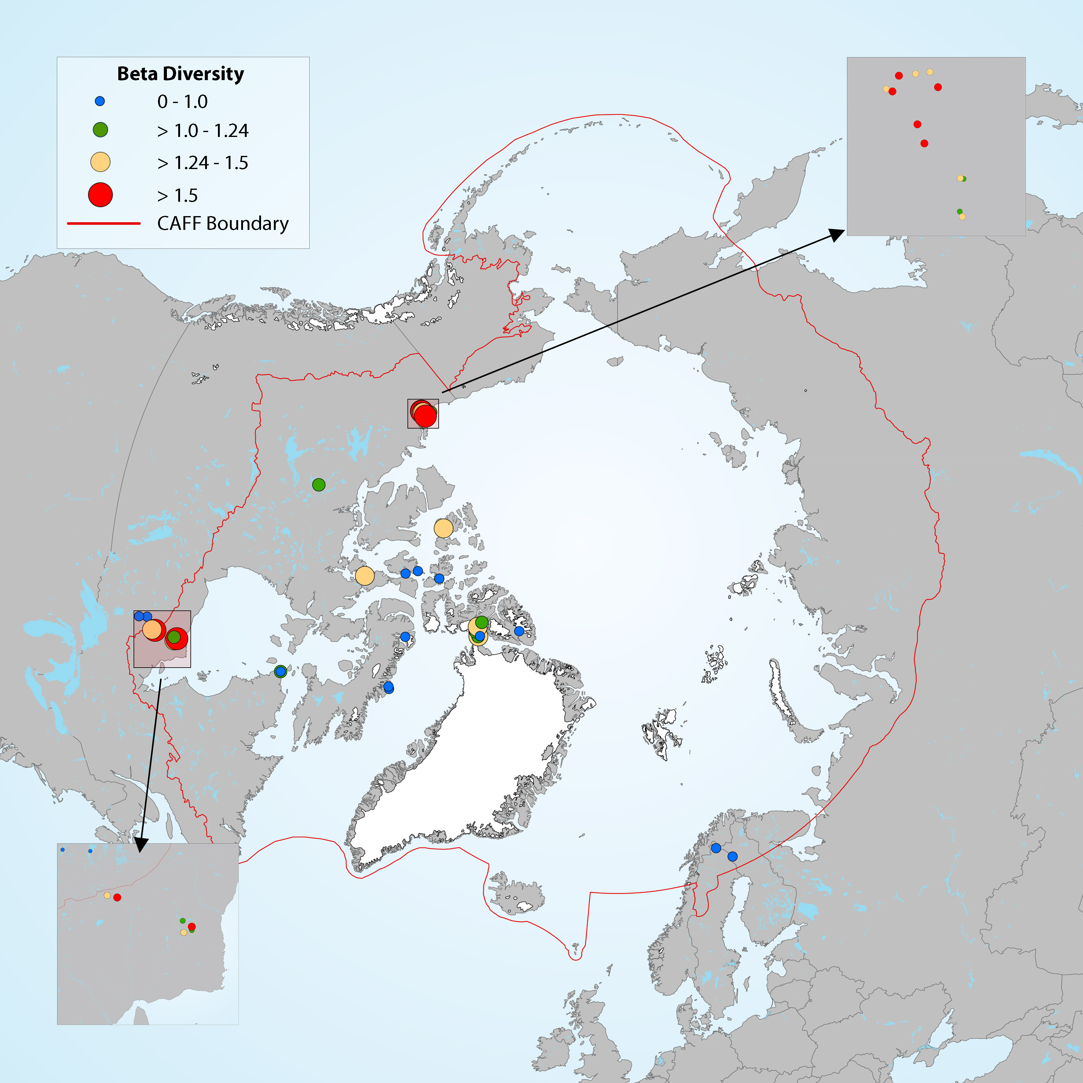
Figure 4-16 Map showing the magnitude of change in diatom assemblages for downcore samples, with beta diversity used as a measure of the compositional differences between samples at different depths along the core. Boundaries for the beta diversity categories are based on distribution quartiles (0-0.1, 0.1-1.24, 1.24-1.5, >1.5), where the lowest values (blue dots) represent the lowest degree of change in diatom assemblage composition along the length of the core in each lake. State of the Arctic Freshwater Biodiversity Report - Chapter 2 - Page 15 - Figure 2-1
-
Tourism use polygons of lakes and areas of trails
-

Get data about the water quality for Ontario's inland lakes. The data is collected through volunteer monitoring efforts – citizen science. The [Lake Partner environment map](https://www.ontario.ca/page/map-lake-partner) The Lake Partner Program (LPP) measures water quality in inland lakes across Ontario. This dataset provides water quality and water clarity data, as well as data on the concentrations of: * total phosphorus * calcium * chloride * sulphate Spatial information for lake monitoring locations across Ontario are also available. Keywords: Lake, Water, Citizen Science, Community Science, Volunteer, Phosphorus, Calcium, Chloride, Water Clarity
-
Part of the Nova Scotia Topographic Database the Nova Scotia Hydrographic Network (Water Features) is updated and maintained from aerial photography. Lakes, Rivers, Islands and many other features are collected and networked into a seamless relation data base. Toponyms are included in the attribute table for named hydrographic features. Hydrographic feature codes and their descriptions are provided with the download in a NSTDB feature code table. Data download also available via GeoNova: https://nsgi.novascotia.ca/WSF_DDS/DDS.svc/DownloadFile?tkey=fhrTtdnDvfytwLz6&id=18 Map service view also available via GeoNova: https://nsgiwa.novascotia.ca/arcgis/rest/services/BASE/BASE_NSTDB_10k_Water_UT83/MapServer?f=jsapi
-
**Bathymetric Maps – Open**, are bathymetric maps that are published under the Open Government Licence – British Columbia (OGL) based on their Province of BC ownership. **The associated resource Bathymetric Maps - Open – Reference Table and Maps** provides a reference table that includes URLs to PDF bathymetric map files published under the OGL. **The associated resource Bathymetric Maps - Open – Reference Table – Data Definitions** provides data definitions for the associated resource Bathymetric Maps - Open – Reference Table and Maps.