 Arctic SDI catalogue
Fisheries management
Type of resources
Available actions
Topics
Keywords
Contact for the resource
Provided by
Years
Formats
Representation types
Update frequencies
status
Service types
-

Pacific Herring spawn index data for British Columbia from 1951 to present. Note that the spawn index is a relative index of spawning biomass. In addition, “NA" indicates that data are unavailable because they are either incomplete or withheld; contact the custodian for more information. For the "Region" column specifically, "NA" indicates that the location is outside stock assessment region boundaries. There are a few caveats to consider when interpreting Pacific Herring spawn index data, which are discussed in the technical report (see supporting documents).
-

Biological samples of Geoduck Clams have been collected during surveys in British Columbia as part of the broader survey objectives of determining Geoduck density, distribution and population structure. Samples of Geoducks were collected from 41 locations throughout British Columbia between 1993 and 2002. Clams were measured for total weight, shell length, shell weight and were aged. Biological parameters are presented here for individual clams sampled. See Bureau D., W. Hajas, N.W. Surry, C.M. Hand, G. Dovey and A. Campbell. 2002. Age, size structure and growth parameters of Geoducks (Panopea abrupta, Conrad 1849) from 34 locations in British Columbia sampled between 1993 and 2000. Can Tech. Rep. Fish. Aquat. Sci. 2413: 84 p. and Bureau D., W. Hajas, C.M. Hand and G. Dovey. 2003. Age, size structure and growth parameters of Geoducks (Panopea abrupta, Conrad 1849) from seven locations in British Columbia sampled in 2001 and 2002. Can. Tech. Rep. Fish. Aquat. Sci. 2494: 29 p.
-
This dataset contains area-based management measures that qualify as 'other effective area-based conservation measures' ('other measures') according to DFO's Operational Guidance for Identifying ‘Other Effective Area-Based Conservation Measures’ in Canada’s Marine Environment (http://www.dfo-mpo.gc.ca/oceans/publications/oeabcm-amcepz/index-eng.html). It also contains basic information about these ‘other measures’, specifically their names, objectives, and prohibitions. The identification of existing, and establishment of new, 'other measures' is an important element of Canada’s strategy to meet its marine conservation targets to protect 5 percent of Canada’s marine and coastal areas by 2017 and 10 percent by 2020. 'Other measures' will be evaluated regularly, taking the most recent available information into account. In addition new 'other measures' will be identified or established over time. Therefore, this data set may change over time, and is considered current as of its publication date stamp. The boundaries and attributes in this dataset are for information purposes only, and should not be considered legally authoritative.
-

In place since fall 1994, the sentinel fisheries program is the result of a collaboration between Fisheries and Oceans Canada (DFO) and Quebec and Newfoundland commercial fishermen's associations. Under this program, contracts are awarded by tender to fishermen’s associations to carry out fishing activities according to scientific protocols developed by DFO. The main objective of this survey is to collect data that will be used to calculate abundance indices for various fish stocks, including cod, Greenland halibut, Atlantic halibut and rockfish. Description of mobile survey The mobile gear sentinel fisheries of the northern Gulf of St. Lawrence are conducted in the sub-division 3Pn and the divisions 4R, 4S and the northern part of the division 4T of the Northwest Atlantic Fisheries Organization (NAFO). This program follows a stratified random survey plan according to depth strata, NAFO divisions and the type of substrate at the bottom. A standard tow is 30 minutes long and made at a speed of 2.5 knots. The fishing gear is a 300 Star Balloon trawl mounted on a Rock Hopper footgear. The trawl mesh size is 145 mm with a liner of 40 mm in the codend. Unless conditions at sea compromise safety during fishing activity, a retaining cable must be used to standardize the horizontal opening between vessels and the various depths fished. Data are collected by observers at sea or by technicians. The data contained in this program are divided into 4 different projects. -The summer series, carried out during the month of July -The fall series, which covers the period from 1995 to 2002 -The winter series, to study the mixing between the different stocks -The CRP (Cod reproductive potential) series, which targets the reproductive potential. Data For each trait, the total catch is sorted and weighed for each species. The number of individuals caught for each unmeasured fish species is noted. Biological data such as length, weight (sampled, per individual, gonad, liver and stomach), age, sex and maturity migth then be collected on a subsample of many species such as Atlantic halibut, Greenland halibut, lumpfish and Atlantic cod, using a variety of protocols. The biological data are divided into 4 files: a “Metadata” file containing set information, a “Catches” file containing catches per set for fish taxa, a “Carbio” file containing biological and morphometric measurements per individual, a “Freql” file containing the length frequency of fish. The data collected as part of this program is available below. It is important to note, however, that 1) only traits deemed successful have been retained; 2) historical data may contain inaccuracies; 3) the most recent survey is not available for validation purposes.
-

This dataset contains area-based management measures that have been recognized as 'other effective area-based conservation measures' (OECMs). It also contains basic information about OECMs, specifically their names, size, objectives, associated prohibitions, and DFO region. Spatial data for OECMs will be evaluated regularly, taking the most recent available information into account. In addition new 'OECMs will be identified over time. Therefore, this dataset may change over time.
-
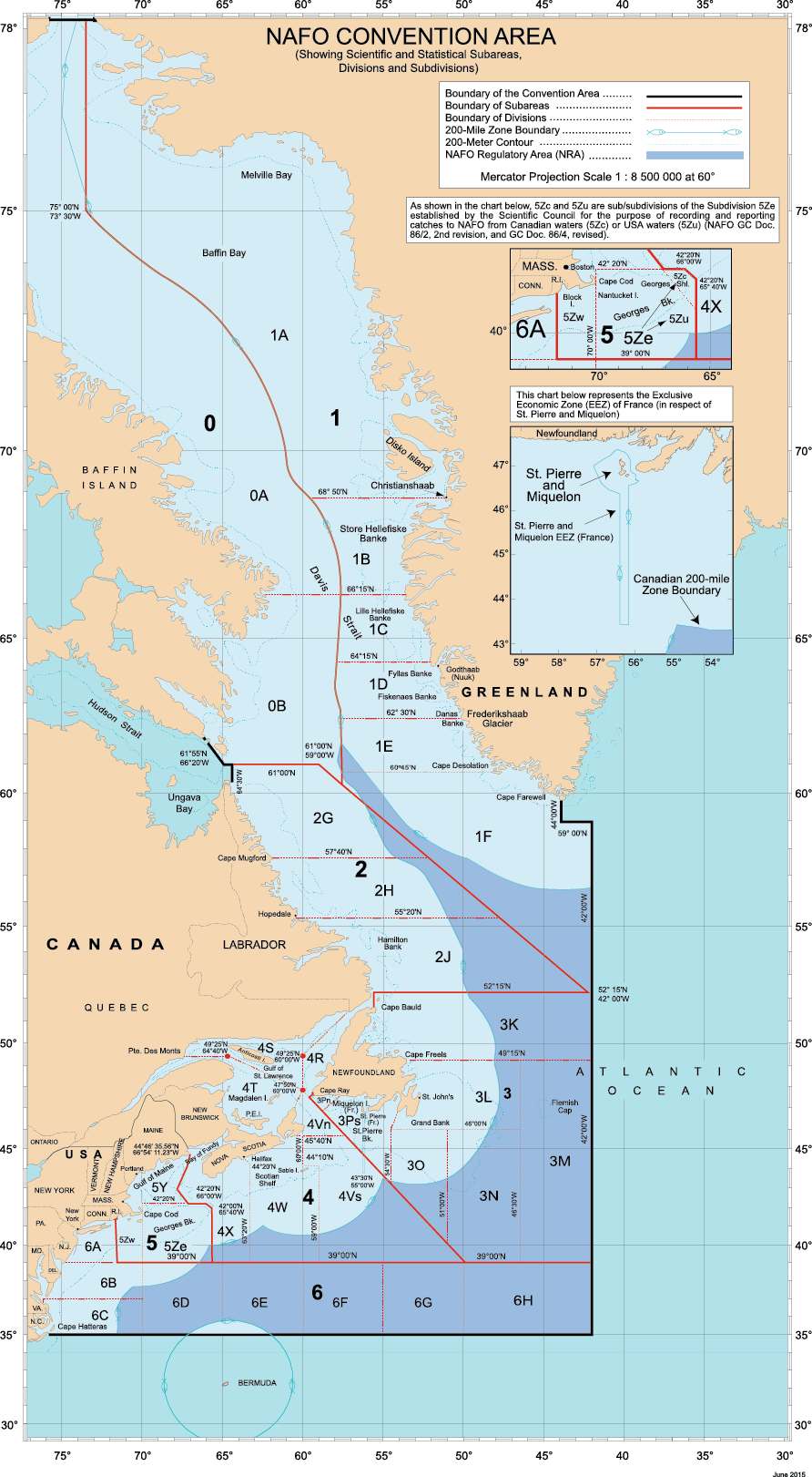
The Gulf of St. Lawrence At-Sea Observer Program is part of the Fisheries Monitoring Policy of the Department of Fisheries and Oceans Canada (DFO) (https://www.dfo-mpo.gc.ca/reports-rapports/regs/sff-cpd/fishery-monitoring-surveillance-des-peches-eng.htm#toc13). Its purpose is to ensure accurate verification of fishing activities at sea by an independent third party, and to provide DFO with scientific data on catches. The fishing industry and DFO depend on the proper communication of this information for fisheries management, monitoring and scientific research activities. Biological data on fish and marine invertebrates collected by the At-Sea Observer Program is one of the sources of information used by DFO to assess the status of these resources. Biological data protocols are the subject of an annual consultation with the biologists responsible for assessing each of the exploited stocks. This dataset contains the sum of weight data for species caught, by NAFO (Northwest Atlantic Fisheries Organization) sub-division and by year from 1999-2023, from commercial species directed fisheries for stock assessments in the Quebec region. It also includes length frequencies for species caught when required by protocol. To preserve the confidentiality of the fishing industry, data are only presented when fishing activity has been observed on a minimum of 5 vessels in a given NAFO area. The data presented are raw and should be interpreted with caution. They may contain errors such as spatial coordinates, landing weights or inaccurate or unreliable species identifications. A brief review of the taxonomy was carried out by DFO taxonomist cited as collaborator. His comments can be found in the “REMARK_IDENT” column preceded by the code “Claude_Nozere”.
-
An exploratory fishery was carried out in the Mackenzie River Delta between 1989 and 1993 at the request of the Inuvik Hunters and Trappers Committee to assess the commercial fishery potential in this area. Data collected during this exploratory fishery was used in two technical reports. Broad whitefish were the target species of this fishery (DFO Technical Report 2180), however other species such as northern pike, inconnu, and lake whitefish were also harvested (DFO Technical Report 2330). Biological data from broad whitefish (fork length, age, gonadosomatic index and instantaneous mortality) were analyzed to assess the impact of an exploratory fishery in the Mackenzie River Delta. The data were collected using variable mesh experimental gill nets and commercial harvesters' 139 mm (5.5”) mesh gill nets. The data suggest that the broad whitefish population might be separated, with larger mature spawners gathering in the main channels prior to spawning and smaller, immature or resting fish staying in side channels away from strong currents. From this analysis we conclude that the size and structure of the broad whitefish population(s) found in this area are stable at the current level of total harvest (commercial and subsistence combined) There may be room for increased harvests but to what level is uncertain. Biological data from northern pike, inconnu, and lake whitefish were analyzed to assess the impact of the fishery on population abundance and structure. All three by catch species support subsistence fisheries in the Mackenzie Delta. lnconnu and lake whitefish migrate substantial distances, crossing land claim borders and are likely fished by a variety of user groups. Northern pike, on the other hand tend to be non-migratory with localized populations that are mainly fished by people living in the near vicinity. A concern was that commercial fishing pressure might reduce the numbers of fish available to subsistence users. Based on trends in size and age frequency, age at maturity, sex ratio, growth rates, and mortality rates, we conclude that inconnu and lake whitefish populations in the Mackenzie Delta have remained healthy and stable at the current harvest levels, however northern pike populations showed a decrease in the proportion of older fish, possibly indicating over-fishing of local stocks. lnconnu and lake whitefish may be able to withstand increased harvest, but to what extent is unknown, given that little reliable information is available on subsistence harvest levels in this region. Increasing harvest levels of pike may be risky and we suggest that a reduction of current commercial harvest quotas be considered.
-

Fisheries and Oceans Canada (DFO) conducted a winter multidisciplinary scientific surveys with a bottom trawl the northern Gulf of St. Lawrence and Cabot Straight from 1978 to 1994. The specificities of the missions onboard the MV Lady Hammond are described below. Objectives: 1. Assess groundfish populations abundance and condition 2. Assess environmental conditions 3. Conduct a biodiversity inventory of benthic and demersal megafauna 4. Collect samples for various research projects Survey description This winter survey covers the northern Gulf of St. Lawrence, that is the divisions 4R, 4S and 3Pn of the Northwest Atlantic Fisheries Organization (NAFO). A stratified random sampling strategy is used for this survey and the fishing gear used on the MV Gadus Atlantica is an Engel 145 Otter trawl. Standard trawling tows last 30 minutes, starting from the time the trawl touches the sea floor. Towing speed is 3.5 knots. Data For each fishing tow, the catch is sorted and weighed by taxa; individuals are counted and biological data are collected on a subsample. For fish, crab and squid, size and weight are measured by individual and, for some species, sex, gonad maturity, and the weight of certain organs (stomach, liver, gonads) are also evaluated. The soft rays of the anal fin are counted for redfish and otoliths are collected for Greenland halibut and Atlantic cod. Invertebrates are weighted and counted (no individual measurements). The biological data are divided into 4 files: a “Metadata” file containing set information, a “Catches” file containing catches per set for fish taxa, a “Carbio” file containing morphometric measurements per individual and a “Freql” file containing the length frequency of fish. It's important to note that this is raw data. Only sets considered successful are retained. In each set, all species are kept, with a few exceptions. For more information please contact the data management team (gddaiss-dmsaisb@dfo-mpo.gc.ca).
-

These datasets show commercial fisheries catch weight landings of directed fisheries and bycatch from the Scotian Shelf, the Bay of Fundy, and Georges Bank from NAFO Divisions 4VWX and the Canadian portions of 5Y and 5Z. Atlantic Canadian inter-regional maps of four species (Atlantic Halibut, Bluefin Tuna, Redfish and Scallop) are also included from NAFO Divisions 4RST, 3KLMNOP, and 2GHJ. Five-year composite maps (2014–2018) that aggregate catches for each map series are publicly available. The maps aggregate catch weight (kg) per 10 km2 hexagon grid cell for selected species, species groupings and gear types to identify important fishing areas. These maps may be used for decision making in coastal and oceans management, including marine spatial planning, environmental emergency response operations and protocols, Marine Stewardship Council certification processes, marine protected area networks, and ecological risk assessment. These datasets have been filtered to comply with the Government of Canada's privacy policy. Privacy assessments were conducted to identify NAFO unit areas containing data with less than five vessel IDs, licence IDs or fisher IDs. If this threshold was not met, catch weight locations were withheld from these unit areas to protect the identity or activity of individual vessels or companies. Maps were created for the following species, species groupings and gear types: 1. Groundfish (all species) 2. Groundfish Bottom Trawl 3. Groundfish Gillnet 4. Groundfish Bottom Longline 5. Groundfish (quarterly composites Q1, Q2, Q3, Q4) 6. Atlantic Cod 7. Atlantic Cod, Haddock and Pollock 8. Flatfish 9. Atlantic Halibut 10. Greenland Halibut (Turbot) 11. Hagfish 12. Cusk 13. Dogfish 14. Redfish 15. Red Hake 16. Silver Hake 17. White Hake 18. Monkfish 19. Sculpin 20. Skate 21. Wolffish 22. Squid 23. Herring 24. Mackerel 25. Large Pelagics 26. Bluefin Tuna 27. Other Tuna 28. Swordfish 29. Porbeagle, Mako and Blue Shark 30. Snow Crab 31. Other Crab 32. Scallop 33. Scallop (quarterly composites Q1, Q2, Q3, Q4) 34. Offshore Clam 35. Shrimp 36. Offshore Lobster 37. Disputed Zone Area 38B Lobster 38. Whelk
-

Fisheries and Oceans Canada (DFO) conducts an annual summer multidisciplinary scientific survey with a bottom trawl in the Estuary and the northern Gulf of St. Lawrence since 1984. Over the years, this survey has been conducted on four vessels: the MV Lady Hammond (1984-1990), the CCGS Alfred Needler (1990-2005), the CCGS Teleost (2004-2021) and the CCGS Cabot (2022-current). It is important to note that the objectives, the methods used and the identification of the species during these surveys have improved over time in response to DFO requests and mandates. The data are therefore not directly comparable between these surveys. The specificities of the missions onboard the MV Lady Hammond are described below. Objectives: 1. Assess groundfish populations abundance and condition 2. Assess environmental conditions 3. Conduct a biodiversity inventory of benthic and demersal megafauna 4. Monitor the pelagic ecosystem 5. Collect samples for various research projects Survey description The survey covers the northern Gulf of St. Lawrence, that is the divisions 4R, 4S and the northern part of division 4T of the Northwest Atlantic Fisheries Organization (NAFO). A stratified random sampling strategy is used for this survey and the fishing gear used on the MV Lady Hammond is a bottom trawl Western IIA. Standard trawling tows last 30 minutes, starting from the time the trawl touches the sea floor. Towing speed is 3.5 knots. Data For each fishing tow, the catch is sorted and weighed by taxa; individuals are counted and biological data are collected on a sub-sample. For fish, crab and squid, size and weight are measured by individual and, for some species, sex, gonad maturity, and the weight of certain organs (stomach, liver, gonads) are also evaluated. The soft rays of the anal fin are counted for redfish and otoliths are collected for redfish and Atlantic cod. Invertebrates are weighted and counted (no individual measurements). The biological data are divided into 4 files: a “Metadata” file containing set information, a “Catches” file containing catches per set for fish taxa, a “Carbio” file containing biological and morphometric measurements per individual and a “Freql” file containing the length frequency of fish. It's important to note that this is raw data. Only sets considered successful are retained. In each set, all species are kept, with a few exceptions. For more information please contact the data management team (gddaiss-dmsaisb@dfo-mpo.gc.ca).