 Arctic SDI catalogue
Education
Type of resources
Available actions
Topics
Keywords
Contact for the resource
Provided by
Years
Formats
Representation types
Update frequencies
status
Service types
-

Location of public schools (French-speaking, English-speaking and special status) as well as private and governmental schools for preschool, primary, secondary, vocational training and adult education. In addition, the location of educational institutions in the college and university networks is also available.**This third party metadata element was translated using an automated translation tool (Amazon Translate).**
-
A map that displays median ages across Canada at three levels of geography according to the 2006 Census.This thematic map presents the population density in Canada based on 2006 census data at three levels of geography: provinces (1:25,000,001 and over), census division (CD) (1:5,000,001 and 1:25,000,000), and census sub-division (CSD) (1:5,000,000 and under). Note: Areas at the CSD level with no associated data will display with a value of 0.
-
This time-enabled map shows the expansion of Canadian Railways, higlighting the rapid expansion of the CPR in the late nineteenth century.
-

Point feature layer showing locations of public schools in Manitoba that offer the French Immersion Program. Point feature layer showing locations of public schools in Manitoba that offer the French Immersion Program. This is an inclusive program intended for all students with various abilities and needs whose first language is not French. The goal of the Program is to develop proud, confident, engaged, plurilingual global citizens. For more information visit Manitoba Advanced Education, Skills and Immigration. Fields included (Alias (Field Name): Field description) SCHOOL_FR_NAME (SCHOOL_FR_NAME): Name of the school in French SCHOOL_EN_PHONE_NBR (SCHOOL_EN_PHONE_NBR): Phone number for the school SCHOOL_FR_PHONE_NBR (SCHOOL_FR_PHONE_NBR): Phone number for the school, in French format DIV_NAME (DIV_NAME): Name of the school division DIV_FR_NAME (DIV_FR_NAME): Name of the school division in French DIV_EN_PHONE_NBR (DIV_EN_PHONE_NBR): Phone number for the division DIV_FR_PHONE_NBR (DIV_FR_PHONE_NBR): Phone number for the division, in French format SCHOOL_ADDR_LINE1 (SCHOOL_ADDR_LINE1): Street address of school SCHOOL_ADDR_LINE2 (SCHOOL_ADDR_LINE2): Second line, if required, of street address SCHOOL_FR_ADDR_LINE1 (SCHOOL_FR_ADDR_LINE1): Street address of school in French SCHOOL_FR_ADDR_LINE2 (SCHOOL_FR_ADDR_LINE2): Second line, if required, of street address in French SCHOOL_CITY_NAME (SCHOOL_CITY_NAME): Name of the city or town that the school is located in SCHOOL_POSTAL_CODE (SCHOOL_POSTAL_CODE): Postal code of the school TRACKS (TRACKS): This field indicates the delivery model used by the school; either single track or dual track MIDDLE_IM (MIDDLE_IM): This field indicates whether the school has a grade 4 entry point LATE_IM (LATE_IM): This field indicates whether the school has a grade 6 or 7 entry point SCHOOL_LOW_GRADE_ENG (SCHOOL_LOW_GRADE_ENG): The lowest grade offering the Program SCHOOL_LOW_GRADE_FR (SCHOOL_LOW_GRADE_FR): The lowest grade, in French, offering the Program SCHOOL_HIGH_GRADE (SCHOOL_HIGH_GRADE): The highest grade offering the Program GRADE_LIST_EN (GRADE_LIST_EN): Comma separated list of grades available in the Program GRADE_LIST_FR (GRADE_LIST_FR): Comma separated list of grades available in the Program, in French Latitude (Latitude): Latitudinal coordinate of the school Longitude (Longitude): Longitudinal coordinate of the school
-

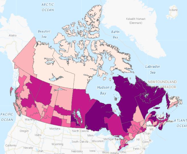
Map of the proportion of individuals (15 years and over) with at least a university bachelor's degree in Official Language Minority Communities. Refers to the individual's educational attainment or highest certificate, diploma or degree obtained by the person. The data used is based on the 2016 Census of Canada, 25% sample, the universe is the population 15 years and over.
-
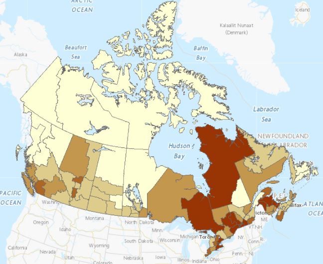
Map of the proportion of individuals (15 years and over) without an educational certificate, diploma or degree in Official Language Minority Communities. Refers to the individual's educational attainment or highest certificate, diploma or degree obtained by the person. The data used is based on the 2016 Census of Canada, 25% sample, the universe is the population 15 years and over.
-
Web map showing locations of public schools in Manitoba that offer the French Immersion Program. Web map showing locations of public schools in Manitoba that offer the French Immersion Program. This is an inclusive program intended for all students with various abilities and needs whose first language is not French. The goal of the Program is to develop proud, confident, engaged, plurilingual global citizens. For more information visit Manitoba Advanced Education, Skills and Immigration.
-
Individuals (15 years and over) without an educational certificate, diploma or degree in Official Language Minority Communities. Refers to the individual's educational attainment or highest certificate, diploma or degree obtained by the person. The data used is based on the 2016 Census of Canada, 25% sample, the universe is the population 15 years and over.
-

Individuals (15 years and over) with at least a university bachelor's degree living in Official Language Minority Communities. Refers to the individual's educational attainment or highest certificate, diploma or degree obtained by the person. The data used is based on the 2016 Census of Canada, 25% sample, the universe is the population 15 years and over.
-
This dataset was created to provide a spatial dataset of the school divisions within the province of Manitoba. This polygon layer depicts official boundaries of the Manitoba School Divisions as per Director of Surveys (DoS) plans. Each DoS number can be found in the field "source". Boundaries are approved by both Manitoba Education and the Director of Surveys of Manitoba. Ward boundaries, schools and the following school divisions are not included in this dataset: Funded Independent, Non-funded Independent, First Nations, Institutional schools, and The Division Scolaire franco-manitobaine. This polygon layer is symbolized by the School Division Names in the field SchoolDiv.The dataset includes the following fields:Alias (Field Name): Description of fieldFID (FID): Identification numberOBJECTID (OBJECTID): Object IDShape Length (Shape_Leng): Length of polygonShape Area (Shape_Area): Area of polygon shapeSchool Division Name (School_Div): Division Name.DoS Source Number (SOURCE): Director of Surveys (DoS) plan number.Website (WEBSITE): Division website address (if available).