 Arctic SDI catalogue
Research
Type of resources
Categories
Available actions
Topics
Keywords
Contact for the resource
Provided by
Years
Formats
Representation types
Update frequencies
status
Service types
Scale
-

The Environmental Studies Research Fund (ESRF) Regions are legally described in Part I and Part II of the Schedule in the Environmental Studies Research Fund Regions Regulations in the Canada Petroleum Resources Act. This data collection is for illustrative purposes only and includes: • 1 dataset illustrating ESRF prescribed regions 1 to 31 as they are described in the ESRF Regions Regulations. • 1 dataset illustrating the areas where levies are no longer applied to ESRF prescribed regions. These areas include lands that are described in the ESRF Regions Regulations but have since been devolved to the Government of Yukon or the Government of Northwest Territories as part of the 2003 Yukon Devolution and 2014 Northwest Territories Devolution, respectively. Once the Yukon Act and Northwest Territories Act came into effect, lands subject to devolution were no longer considered frontier lands or Canada lands, and therefore no longer subject to ESRF levies under the Canada Petroleum Resources Act. The geospatial extents used in this dataset represent those identified in the Devolution Agreements. Future updates to Part II, section 3 of the Schedule in the ESRF Regions Regulations will reflect the Yukon and Northwest Territories Devolutions. • 3 maps (National, North, South). • 1 table compiling the historical levies for each ESRF prescribed region. Context: The Environmental Studies Research Fund (ESRF) is a research program which sponsors environmental and social studies designed to assist in the decision-making process related to oil and gas exploration and development on Canada's frontier lands. The ESRF is directed by a 12-member Management Board which includes representation from the federal government, the Canada-Newfoundland and Labrador Offshore Petroleum Board (C-NLOPB), the Canada-Nova Scotia Offshore Energy Regulator (CNSOER), the oil and gas industry, and the public. The ESRF is administered by a secretariat which resides in the Offshore Management Division in Natural Resources Canada. Since 1987, the ESRF has received its legislative mandate through the Canada Petroleum Resources Act. The ESRF regions are described in the Environmental Studies Research Fund Regions Regulations. As well, the Canada-Newfoundland and Labrador Atlantic Accord Implementation Act and the Canada–Nova Scotia Offshore Petroleum Resources Accord Implementation and Offshore Renewable Energy Management Act provide legislative direction in the southern ESRF regions. Funding for ESRF is collected annually through levies paid by lease-holding oil and gas companies active in a specific ESRF region. In accordance with the legislation, levies are recommended by the Management Board to the Ministers of Natural Resources and Crown-Indigenous Relations and Northern Affairs for approval. Levies in the southern regions in areas governed by an offshore Accord are subject to final approval by the respective offshore regulator (i.e., the C-NLOPB, or the CNSOER). Levies are calculated by multiplying the levy rate of a region by the number of hectares of land under lease. The ESRF has sponsored studies on biodiversity; environmental effects and monitoring; social and economic issues; ice, icebergs, and ice detection; oil spill research and countermeasures; sea bottom ice scour; sediment transport; Indigenous Knowledge; and waves.
-

During the October 28 2012 moment magnitude (Mw) 7.8 earthquake offshore Haida Gwaii, British Columbia, the Geological Survey of Canada had three Internet Accelerograph (IA) stations that recorded the strong ground motions resulting from this event. These data have been used in a number of publications since 2013. Three-component, instrument calibrated, unfiltered numerical acceleration data for the three stations PRP01 (Prince Rupert), MSS01 (Masset) and QCC01 (Daajing Giids) are now easily accessible in miniseed and ascii formats. Details of IA are available here: https://www.earthquakescanada.nrcan.gc.ca/stndon/CNSN-RNSC/sm/IA_Details-en.php
-
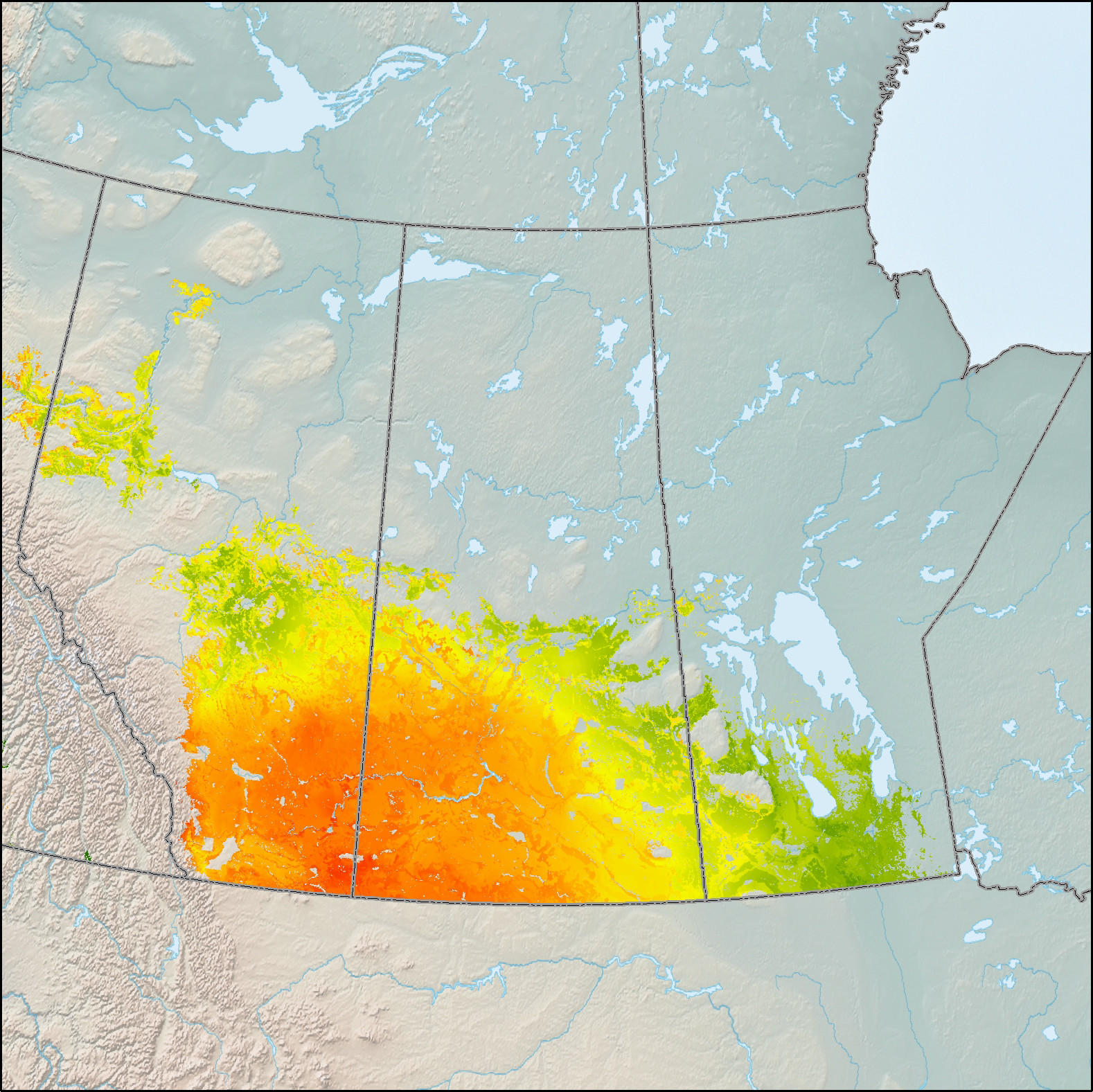
This data depicts site suitability for the establishment of area-based Short Rotation Woody Crops (SRWC) of hybrid poplar on lands eligible (i.e. non-forested) for afforestation across Canada. Determining the feasibility of a large-scale afforestation program is one approach being investigated by the Government of Canada to increase Canada's potential to sequester carbon from the atmosphere and/or produce bioproducts and bioenergy. Large-scale afforestation, however, requires knowledge of where it is suitable to establish and grow trees. Spatial models based on Boolean logic and/or statistical models within a geographic information system may be used for this purpose, but empirical environmental data are often lacking, and the association of these data to land suitability is most often a subjective process. As a solution to this problem, a fuzzy-logic modeling approach to assess site suitability for afforestation of hybrid poplar (Populus spp.) and willow (Salix spp.) in Canada was developed. Expert knowledge regarding the selection and magnitudes of environmental variables were integrated into fuzzy rule sets from which estimates of site suitability were generated and spatially presented. The environmental variables selected included growing season precipitation, climate moisture index, growing degree days, the Canada Land Inventory capability for agriculture and elevation. Site suitability is generally defined as the fitness of a given type of land for a particular use. For this assessment, site suitability was defined as the fitness of edaphic, climatic and topographic conditions to establish and grow SRWC species at rates 8 times those of native species. Suitability index values range from 1-100, with higher values corresponding to higher suitability. Approximately 246,000 km2, or 38% of the eligible land base within Canada was found to be suitable for afforestation using Short Rotation Woody Crops (SRWC) of hybrid poplar and/or willow.
-

Being anxious to participate in the adaptation of agricultural businesses in a context of climate change, MAPAQ has commissioned a study to better identify the challenges current and future of water management. The mandate involved drawing up a portrait of needs. water supplies at the regional level of the various users (agricultural and residential sectors, as well as only institutional, commercial and industrial) to understand what uses and users of water may be the most affected in the future by climate change. The project had also the objective of identifying innovations that would mitigate conflicts of use some water. Beyond data, the project was based on a participatory approach and called on the participation of the regional actors concerned. A first phase (RADEAU 1) started in 2016 covers the regions of Montérégie, Estrie, Chaudière-Appalaches, Lanaudière and Center-du-Quebec. A second phase (RADEAU 2) began in 2017 for six other regions: Mauricie, Laval, Bas-Saint-Laurent, Capitale-Nationale, Laurentides and Outaouais.**This third party metadata element was translated using an automated translation tool (Amazon Translate).**
-

This data depicts site suitability for the establishment of area-based Short Rotation Woody Crops (SRWC) of willow on lands eligible (i.e. non-forested) for afforestation across Canada. Determining the feasibility of a large-scale afforestation program is one approach being investigated by the Government of Canada to increase Canada's potential to sequester carbon from the atmosphere and/or produce bioproducts and bioenergy. Large-scale afforestation, however, requires knowledge of where it is suitable to establish and grow trees. Spatial models based on Boolean logic and/or statistical models within a geographic information system may be used for this purpose, but empirical environmental data are often lacking, and the association of these data to land suitability is most often a subjective process. As a solution to this problem, a fuzzy-logic modeling approach to assess site suitability for afforestation of hybrid poplar (Populus spp.) and willow (Salix spp.) in Canada was developed. Expert knowledge regarding the selection and magnitudes of environmental variables were integrated into fuzzy rule sets from which estimates of site suitability were generated and spatially presented. The environmental variables selected included growing season precipitation, climate moisture index, growing degree days, the Canada Land Inventory capability for agriculture and elevation. Site suitability is generally defined as the fitness of a given type of land for a particular use. For this assessment, site suitability was defined as the fitness of edaphic, climatic and topographic conditions to establish and grow SRWC species at rates 8 times those of native species. Suitability index values range from 1-100, with higher values corresponding to higher suitability. Approximately 246,000 km2, or 38% of the eligible land base within Canada was found to be suitable for afforestation using Short Rotation Woody Crops (SRWC) of hybrid poplar and/or willow.
-
Most of the layers of on the e-Atlas web site. A compliant implementation of WMS 1.1.1 plus most of the SLD 1.0 extension (dynamic styling). Can also generate PDF, SVG, KML, GeoRSS
-
The dataset contains place names and associated historical and explanatory information for Northern East Greenland based on the book Northern East Greenland’s research history and place names by A.K. Higgins, published by GEUS in 2010. The dataset includes geographic locations of place names together with their explanations and historical background. The original maps and place name information have been converted to a web-based GIS format, allowing users to search for place names via free-text search and view their spatial distribution on an interactive map. The dataset forms part of the web-based presentation of Northern East Greenland’s place names and research history.
-

This data depicts the locations of Short Rotation Woody Crop (SRWC) research, development and demonstration sites established across Canada by the Canadian Wood Fibre Centre, its partners and/or private land owners. Short Rotation Woody Crops represent enormous potential with respect to future sources of bioenergy and/or sinks for carbon. Since 2002, the Silviculture Innovation Group of the Canadian Wood Fibre Centre has established over 1 000 hectares of "high yield afforestation", “mixedwood afforestation” and "concentrated woody biomass" SRWC systems across Canada. The refinement of the biological and operational components of these systems is ongoing to improve production efficiencies, reduce costs, and enhance site sustainability. Development, assessment and validation of value-chain options for the establishment, recovery, transportation, handling and conditioning phases of these short rotation woody feedstock systems is also being performed. The refinement and demonstration of operational logistics along with the identification of supply and value-chain options will promote the concept of SRWC from basic research and development to the point of commercial uptake.
-
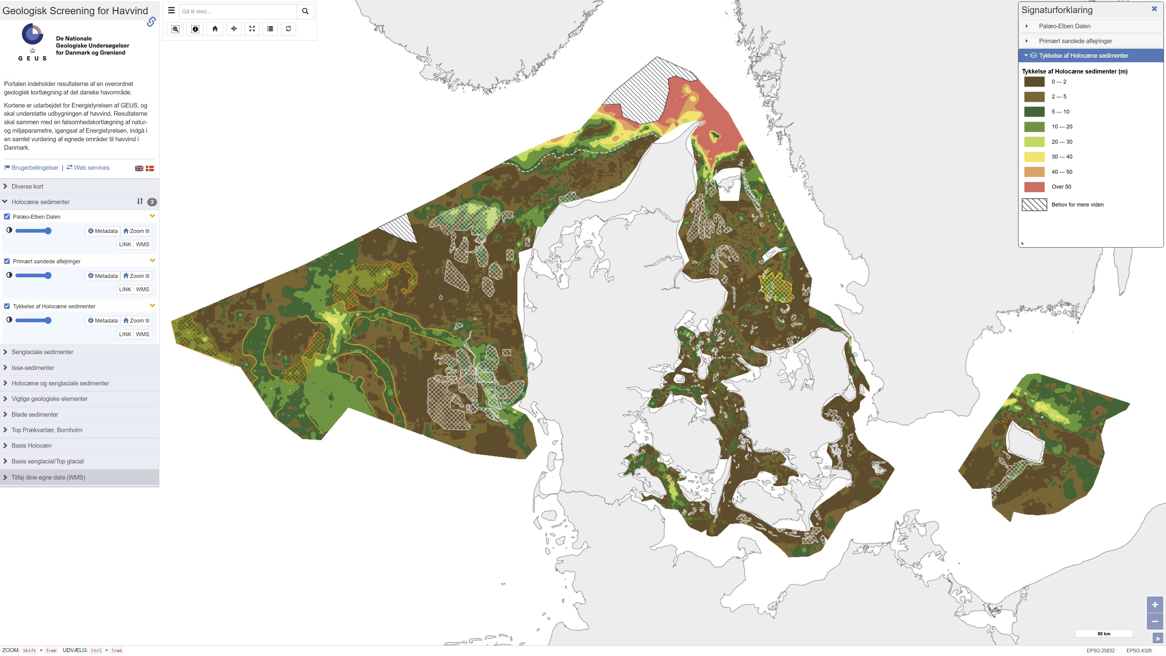
This repository contains maps of the thickness of late glacial and Holocene deposits in the Danish sea area, prepared as a basis for planning offshore wind. These are unconsolidated sediments that have not been overrun by the ice sheets of the ice ages, and therefore may have low geotechnical strength parameters. This is a large-scale and very general mapping, and no detailed interpretation of the distribution of sand and clay/mud/silt, respectively, has been made. In relation to the foundations of offshore wind turbines, sandy deposits will typically not pose a challenge, while soft deposits of clay, mud and silt in large thicknesses are assumed to pose foundation challenges. In addition to separate maps of the thickness of late glacial and Holocene deposits, a map of the total thickness of these two units has also been prepared, which thus constitutes a map of the total thickness of potentially soft sediments. Finally, the thickness of potentially soft sediments is used to divide the Danish sea area into categories in relation to the probability of larger thicknesses of soft sediments that could give rise to foundation challenges. Other maps are the thickness of potentially soft glacial lake sediments in the North Sea, the depth to the Pre-Quaternary surface in the waters around Bornholm, as well as the depth to the base of the Holocene deposits and the depth to the base of the late glacial deposits/top of the glacial deposits in the Danish sea area. As a supplement to the maps, a number of themes show where the late glacial and Holocene deposits are primarily expected to consist of sandy sediments. In addition, a number of themes show the Danish exclusive economic zone (EEZ), the location of conceptual geological models that can be seen in the overall report, all interpreted seismic lines, areas with near-surface gas in the sediments, interpreted distribution of the Palaeo-Elbe Valley in the North Sea, distribution of the Weichsel ice and ice-affected sediments in the North Sea, buried valleys (Prins & Andresen 2019; van der Vegt et al. 2012; Ottesen et al. 2020; Kirkham et al. 2024; Sandersen & Jørgensen 2016), structural elements (Al Hseinat & Hübscher 2017; Jensen et al. 2002), ice margin lines (Lange 1984; Kjær et al. 2003; Pedersen 2005; Phillips et al. 2018, 2022; Kirkham et al. 2024; Szuman et al. 2024; Pedersen & Boldreel 2017). The data basis for the work has primarily been new and existing near-surface seismic data and vibrocore drilling. The mapping was carried out for the Danish Energy Agency by GEUS, and is intended to support the development of offshore wind. The results, together with a sensitivity mapping of natural and environmental parameters, initiated by the Danish Energy Agency, are to be included in an overall assessment of suitable areas for offshore wind in Denmark.
-
This dataset contains average concentrations of water chemistry collected from stream catchments C31, C32, C33, C34, C35, C37, C38, C39, C42, C46, C47, C49, and C50 in the Turkey Lakes Watershed, approximately 60 km northwest of Sault Ste. Marie, Ontario, Canada. These are average concentrations recorded from 1981-2018 in milligrams per litre (mg/L) of major ions (Ca, Mg, K, Na, SO4, Cl, NO3-N, NH4-N) and some nutrients (TP, TN) collected by the Great Lakes Forestry Centre. Samples are collected according to variable schedules such that frequency generally increased with increasing stream flow, (sampling period was shortest during spring runoff, 1-3 days, and longest during winter, 2-3 weeks). Sampling was accomplished by rinsing an appropriately cleaned 2-litre, polyethylene bottle at least 3 times with stream water followed by immersion to collect the final sample. Care was taken to not disturb the stream sediments throughout the sampling procedure. pH and conductivity testing is completed right after sampling. Other chemical analyses are completed by the Great Lakes Forestry Centre in Sault Ste. Marie within 2 weeks of collection. Sample integrity was maintained through storage in the dark at 4 degrees Celsius and analyzed at room temperature.