 Arctic SDI catalogue
Road maps
Type of resources
Available actions
Topics
Keywords
Contact for the resource
Provided by
Formats
Representation types
Update frequencies
status
-

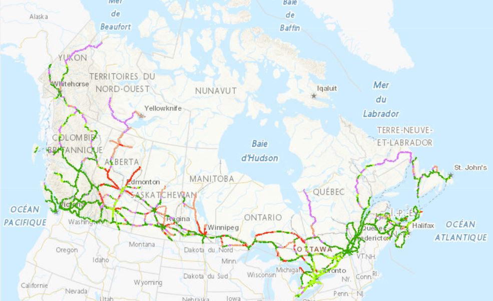
Notice - Replacement of the English and French Web services (WMS and ESRI REST) with a bilingual one. The NRN product is distributed in the form of thirteen provincial or territorial datasets and consists of two linear entities (Road Segment and Ferry Connection Segment) and three punctual entities (Junction, Blocked Passage, Toll Point) with which is associated a series of descriptive attributes such as, among others: First House Number, Last House Number, Street Name Body, Place Name, Functional Road Class, Pavement Status, Number Of Lanes, Structure Type, Route Number, Route Name, Exit Number. The development of the NRN was realized by means of individual meetings and national workshops with interested data providers from the federal, provincial, territorial and municipal governments. In 2005, the NRN edition 2.0 was alternately adopted by members from the Inter-Agency Committee on Geomatics (IACG) and the Canadian Council on Geomatics (CCOG). The NRN content largely conforms to the ISO 14825 from ISO/TC 204.
-

Canada Center for Mapping and Earth Observation (CCMEO)'s basemap is essential in supporting the Government of Canada’s priorities in areas such as open government, climate change mitigation, Indigenous reconciliation, emergency management, disaster preparedness and response, sustainable natural resource management, infrastructure planning, economy/labour and more. It reinforces CCMEO’s commitment to improving the accessibility, interoperability and integration of geospatial data across Canada. CCMEO currently offers multiple basemap types which include the following found in this series: - Transportation basemap (CBMT) in raster tile format - Transportation basemap (CBMT) in vector tile format EPSG: 3857 (WGS84 Pseudo-Mercator) - Transportation basemap (CBMT) in vector tile format EPSG: 3978 (NAD83 Canada Atlas Lambert) - Digital Elevation Model (DEM) - hillshade basemap (CBME) - Simple grey basemap - Provinces/Territories basemap - Grids (Lat/Long, NTS and UTM) basemap
-
The Zero Emission Vehicle Infrastructure Program (ZEVIP) aims at addressing the lack of charging infrastructure in Canada, one of the key barriers to zero emission vehicle adoption by increasing the availability of localized charging where Canadians live, work, travel and play. This Planning Map for Public EV Charging Infrastructure identifies priority areas and accounts for available charging infrastructure and expected charging needs with a focus on public corridor charging. To optimize web performance when using the map, it is recommended you zoom into the areas you are exploring. Priority areas are identified on a scale ranging from lowest to highest priority. Public Corridor Charging includes the EV charging needs of those travelling longer distances on highways and major roads. The objective is to ensure that EV drivers can travel over the majority of Canada’s road network connecting most communities in an EV without being limited on vehicle range. The map identifies priority locations within 1.6 kilometres of major roads based on criteria such as, traffic, expected EV adoption and distance between chargers
-

The Canada Basemap – Transportation (CBMT) is a vector tile service that provides spatial reference context with an emphasis on transportation networks across Canada. It is designed especially for use as a background layer in a web mapping application or geographic information system (GIS). Access: Access is free of charge under the terms of the Open Government Licence - Canada. Data Sources: Data for the CBMT is sourced from multiple datasets. - Topographic data of Canada - CanVec Series. - “Automatically Extracted Buildings” GeoBase (a raw digital product in vector format automatically extracted from airborne Lidar data, high-resolution optical imagery or other sources). - Open Street Map (OSM) data available under the Open Database License (https://www.openstreetmap.org/copyright). - Official names from the Canadian Geographical Names Database (CGNDB). Geographic Coverage: CBMT has complete coverage of the world, with full datasets in Canada and only partial data in other parts of the world including boundaries, Country Names, and major cities. Data Update Frequency: Updates are applied monthly to reflect the latest updates in the source datasets. Projection: Data is provided in the EPSG:3857 (WGS84 Pseudo-Mercator) projected coordinate system. Layer Access: - CBMT is accessible via the ArcGIS Online item link with the applied style or it can also be accessed directly with the default style using the following Vector Tile Server: https://tiles.arcgis.com/tiles/HsjBaDykC1mjhXz9/arcgis/rest/services/CBMT_CBCT_3857_V_OSM/VectorTileServer - In QGIS or other applications that require the style JSON, the following link can be used: https://arcgis.com/sharing/rest/content/items/800d755712e8415aab301b9d55bc2800/resources/styles/root.json Use Cases: This layer is suitable for use in any map as a basemap layer and can be modified to meet the needs of the project by editing the JSON style in the Vector Tile Style editor. Additional Versions: - A geometry-only version (CBMT3857GEOM) and a text-only version (CBMT3857TXT) are available. - French versions of the basemap are accessible via the Carte de base du Canada - Transport 3857 V (CBCT3857).
-

The Canada Basemap – Transportation (CBMT) is a vector tile service that provides spatial reference context with an emphasis on transportation networks across Canada. It is designed especially for use as a background layer in a web mapping application or geographic information system (GIS). Access: Access is free of charge under the terms of the Open Government Licence - Canada. Data Sources: Data for the CBMT is sourced from multiple datasets. - Topographic data of Canada - CanVec Series - “Automatically Extracted Buildings” GeoBase (a raw digital product in vector format automatically extracted from airborne Lidar data, high-resolution optical imagery or other sources.) - Open Street Map (OSM) data available under the Open Database License (https://www.openstreetmap.org/copyright). - Official names from the Canadian Geographical Names Database (CGNDB). Geographic Coverage: CBMT covers the entire geographic area of Canada and some major transportation routes and cities in the northern States of the USA. Data Update Frequency: Updates are applied monthly to reflect the latest updates in the source datasets. Projection: Data is provided in the EPSG:3978 (NAD83 Canada Atlas Lambert) projected coordinate system. Layer Access: - CBMT is accessible via the ArcGIS Online item link with the applied style or it can also be accessed directly with the default style using the following Vector Tile Server: https://tiles.arcgis.com/tiles/HsjBaDykC1mjhXz9/arcgis/rest/services/CBMT_CBCT_3978_V_OSM/VectorTileServer - In QGIS or other applications that require the style JSON, the following link can be used: https://arcgis.com/sharing/rest/content/items/708e92c1f00941e3af3dd3c092ae4a0a/resources/styles/root.json Use Cases: This layer is suitable for use in any map as a basemap layer and can be modified to meet the needs of the project by editing the JSON style in the Vector Tile Style editor. Additional Versions: - A geometry-only version (CBMT3978GEOM) and a text-only version (CBMT3978TXT) are available. - French versions of the basemap are accessible via the Carte de base du Canada - Transport 3978 V (CBCT3978).
-
The Canada Basemap Transportation (CBMT) is a raster tile service that provides spatial reference context with an emphasis on transportation networks across Canada. It is designed especially for use as a background layer in a web mapping application or geographic information system (GIS). Access: Access is free of charge under the terms of the Open Government Licence - Canada. Data Sources: Data for the CBMT is sourced from the following datasets: - Topographic data of Canada – CanVec Series - Official names from the Canadian Geographical Names Database (CGNDB). Projections: - Data is provided in the EPSG:3978 (NAD83 Canada Atlas Lambert) projected coordinate system. - Data is provided in the EPSG:3857 (WGS84 Pseudo-Mercator) projected coordinate system. Geographic Coverage: - The CBMT in the EPSG:3857 has complete coverage of the world, with full datasets in Canada and only partial data in other parts of the world including boundaries, Country Names, and major cities. - The CBMT in the EPSG:3978 covers the entire geographic area of Canada and some major transportation routes and cities in the northern States of the USA. Additional Versions: - The CBMT is available as a dynamic service (WMS) or a tiled service (ESRI REST and WMTS). - A geometry-only version (CBMT GEOM) and a text-only version (CBMT TXT) are available. - French versions of the basemap are accessible via the Carte de base du Canada - Transport (CBCT).