 Arctic SDI catalogue
Transport
Type of resources
Available actions
Topics
Keywords
Contact for the resource
Provided by
Years
Formats
Representation types
Update frequencies
status
Service types
Scale
-

Location of public transport connection points in the City of Repentigny.**This third party metadata element was translated using an automated translation tool (Amazon Translate).**
-

Graphic representation (linear element) of the streets on which trucks, tool vehicles and equipment vehicles are authorized to drive at all times or during the day only (7:00 a.m. to 7:00 p.m.) as well as the traffic signs (point element) attached to them (L-10400). Note that the display of the panels requires the use of the Laval_signalisation.ttf font**This third party metadata element was translated using an automated translation tool (Amazon Translate).**
-
Launched in 2017, the Cumulative Effects of Marine Shipping (CEMS) initiative is part of Canada’s $1.5 billion Oceans Protection Plan, which is providing economic opportunities to Canadians today, while protecting our coasts and waterways for future generations. The Cumulative Effects of Marine Shipping initiative is another way that the Government of Canada is protecting our coasts and waterways. https://tc.canada.ca/en/marine-transportation/marine-pollution-environmental-response/cumulative-effects-marine-shipping As part of this initiative, Transport Canada is working with Indigenous partners and stakeholders in six pilot areas across Canada. Together, we are trying to understand the effects of marine shipping in various coastal areas. These pilot areas include: - North Coast British Columbia - South Coast British Columbia - St. Lawrence and Saguenay Rivers, Quebec - Bay of Fundy, New Brunswick and Nova Scotia - Placentia Bay, Newfoundland - Cambridge Bay, Nunavut
-

2015 to 2018 Capital Bridges
-
2015 to 2018 Capital Roads
-
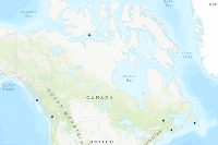
The Atlas of Canada Base Maps provide coverage of the entire Canadian landmass. Data elements are feature coded and structurally clean. Base map components are available in five scales and a number of data exchange formats. The 1:2 million and 1:7.5 million scales are the primary bases for all Atlas products. The 1:30 million scale data have been generalized from the two larger scales. The data set covers: drainage (coastlines, rivers, lakes), boundaries (federal, provincial, district, dividing lines), transportation (primary and secondary highways, selected ferry routes, rail networks), populated places, national parks. Atlas information is two-dimensional layered vector data.
-

Individual trips as recorded by the City of Montreal's Mon RésoVélo application. This mobile application was developed to collect information on bicycle trips within the Montreal metropolitan area. App users installed the app on their phones and needed to activate the app to record a trip. The data provided here are the individual trips recorded by the application and processed to preserve the privacy of users. Due to the collection method (voluntary collection without user selection), it is not possible to guarantee that this data is fully representative of bicycle use (e.g. representation bias in users of the application, etc.) Other limitations to these data are listed in the methodology section.**This third party metadata element was translated using an automated translation tool (Amazon Translate).**
-
The Atlas of Canada Base Maps provide coverage of the entire Canadian landmass. Data elements are feature coded and structurally clean. Base map components are available in five scales and a number of data exchange formats. The 1:2 million and 1:7.5 million scales are the primary bases for all Atlas products. The 1:30 million scale data have been generalized from the two larger scales. The data set covers: drainage (coastlines, rivers, lakes), boundaries (federal, provincial, district, dividing lines), transportation (primary and secondary highways, selected ferry routes, rail networks), populated places, national parks. Atlas information is two-dimensional layered vector data.
-
The Atlas of Canada Base Maps provide coverage of the entire Canadian landmass. Data elements are feature coded and structurally clean. Base map components are available in five scales and a number of data exchange formats. The 1:2 million and 1:7.5 million scales are the primary bases for all Atlas products. The 1:30 million scale data have been generalized from the two larger scales. The data set covers: drainage (coastlines, rivers, lakes), boundaries (federal, provincial, district, dividing lines), transportation (primary and secondary highways, selected ferry routes, rail networks), populated places, national parks. Atlas information is two-dimensional layered vector data.