 Arctic SDI catalogue
harvest
Type of resources
Available actions
Topics
Keywords
Contact for the resource
Provided by
Years
Formats
Representation types
Update frequencies
status
Service types
Resolution
-

Spatial location of all harvesting identified in the first 10 years of 2012 Forest Management Plans for Crown timber licenses. Blocks are identified by broad treatment category and by the period (2012-2016 and 2017-2022) they are available for harvest.
-

This layer contains attribute Opening information only and can be used in conjunction with other layers. RESULTS Openings is an administrative boundary that has been harvested with reforestation obligations or natural disturbance with intended forest management on Crown Land. This is a part of the Silviculture and Land Status dataset, which includes tracking achievmeent of silviculture obligations on Crown Land. Non-spatial attribute data delivered in CSV format
-

The purpose of this feature class is to identify the individual annual allowable cut and annual limit areas as referred to in the Forest Resources Act subsection 20(2) and 31(10 of the Forest Resources Regulation). Where there is no approved Forest Resources Management Plan (FRMP) for an area, forest resources harvesting can only be authorized in an amount less than that prescribed by regulation for that area. The Forest Resources Regulation subsection 31(1) establishes the annual limits for harvesting timber resources for areas without an FRMP. These areas are referred to as the Annual Limit Regions in Schedule 1 of the Regulation titled Timber Harvesting Areas. These annual limits are set as the annual allowable cut for each of the areas, until such time as a Forest Resources Management Plan is approved for that area. Distributed from [GeoYukon](https://yukon.ca/geoyukon) by the [Government of Yukon](https://yukon.ca/maps) . Discover more digital map data and interactive maps from Yukon's digital map data collection. For more information: [geomatics.help@yukon.ca](mailto:geomatics.help@yukon.ca)
-
This is a spatial layer that reflects operational activities for harvesting authorities. The harvesting authority is a legal area cleared by the Ministry of Forests and Range (that is, no other claims for the land exist) for harvesting purposes. This corresponds to the outlined areas on the Exhibit A maps. The Forest Tenures Section (FTS) is responsible for the creation and maintenance of digital Forest Atlas files for the province of British Columbia encompassing Forest and Range Act Tenures. It also supports the forest resources programs delivered by the MoFR. Each feature contains a Ministry of Forests and Range (MoFR) FEATURE_CLASS_SKEY (number) column that further defines the type of that feature. The layer contains harvesting authority boundaries for the following feature classes: Christmas Tree Permit (489), Forest Licence Cutting Permit (556), Licence to Cut (615), Timber Licence Cutting Permit (811), Timber Sale Licence Major Cutting Permit (818), Timber Sale Licence Minor (819), Tree Farm Licence Cutting Permit (834), WoodLot Licence Cutting Permit (864), Timber Sale Licence Minor Cutting Permit (917), and Community Forest Cutting Permit (2401). Each harvesting authority has a life cycle status code that is either PENDING - the harvesting authority has been submitted as a new harvesting authority or an amendment, but is not yet approved or rejected, ACTIVE - the harvesting authority is approved and activities may be taking place on the harvesting authority, or RETIRED - all activities have been completed for the harvesting authority
-
Information about the hauling permission for a timber tenure. For some Road Permits and Licences to Cut, no hauling permission is granted.
-
RESULTS Openings are administrative boundaries for areas harvested with silviculture obligations or natural disturbances with intended forest management activities on Crown Land. The RESULTS openings_svw is a spatial view made up of a number of tables containing information on disturbance dates, generalized bec, forest district, opening category, opening status, previous tree species, opening gross area, average slope, average elevation, aspect, along with maximum and minimum elevation values, and many more fields.
-
Registered Trapping Concessions (RTCs) are legal boundaries that define an area where the holder of the concession has the exclusive right to trap furbearing animals. Because trapping is done primarily along waterways, RTCs are often defined by watersheds, using height of land (ridges and mountain peaks) as their boundaries. This is the opposite of GMAs which are defined by mountains. Sometimes RTCs are grouped together to form a Group Trapping Concession (in which groups of individual share the right to trap). This may or may not involve the elimination of the component RTC boundaries. The Yukon has 360 RTCs and 13 Group Trapping Concessions. Only Kluane National Park, Kluane Wildlife Sanctuary, and Ddhaw Ghro Habitat Protection are are not covered by RTCs. This data was built using the 1:250,000 National Topographic Data Base (NTDB) as the digitizing base. Distributed from [GeoYukon](https://yukon.ca/geoyukon) by the [Government of Yukon](https://yukon.ca/maps) . Discover more digital map data and interactive maps from Yukon's digital map data collection. For more information: [geomatics.help@yukon.ca](mailto:geomatics.help@yukon.ca)
-
An opening's disturbance and silviculture activities reported into RESULTS. Most activities are within opening boundaries with the exception of broadcast treatments. An opening may have more than one activities associated with it. Activities may also overlap each other. Reporting of disturbance and silviculture attribute information is a mandatory requirement while the map is optional. This is part of the Silviculture and Land status Tracking dataset, which includes tracking harvesting and silviculture obligations on Crown Land
-
Created for distribution by the GeoYukon application as a comprehensive resource for all publicly available Forestry information in the Government of Yukon. This data may be used directly by other applications to dynamically display Yukon data; however, it may be subject to change as data sets are updated or added.
-
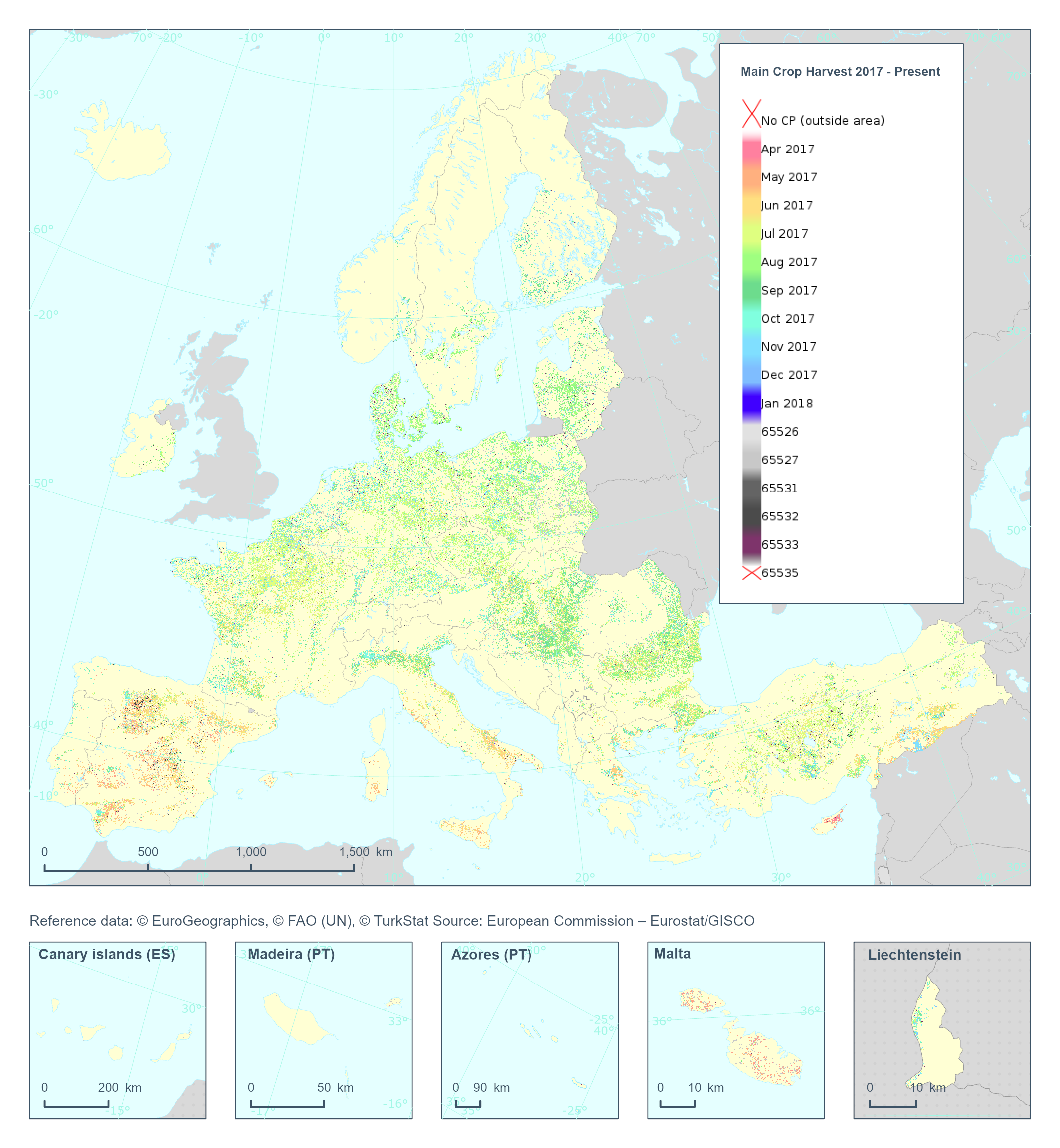
The High Resolution Layer Cropping Patterns - Main Crop Harvest (CPMCH) raster product provides the harvest date of the main (annual) crop expressed in days of the year (DOY). The harvest is considered as the time of removal of most of the biomass. YYDOY where YY = last 2 digits of the year (e.g. 19 for 2019) and DOY is the day of the year (1-365) This dataset is provided annually starting in 2017 with 10 meter rasters (fully conformant with the EEA reference grid) in 100 x 100 km tiles covering the EEA38 countries. High Resolution Layer Croplands product is part of the European Union’s Copernicus Land Monitoring Service. Confidence layer available for the dataset. This dataset includes data from the French Overseas Territories (DOMs)