 Arctic SDI catalogue
Administrative boundaries
Type of resources
Available actions
Topics
Keywords
Contact for the resource
Provided by
Years
Formats
Representation types
Update frequencies
status
Service types
Scale
-
Delimited area of the Core Area Sector Plan as of 2005. https://ncc-ccn.gc.ca/our-plans/canadas-capital-core-area-sector-plan https://ncc-website-2.s3.amazonaws.com/documents/01.pdf
-
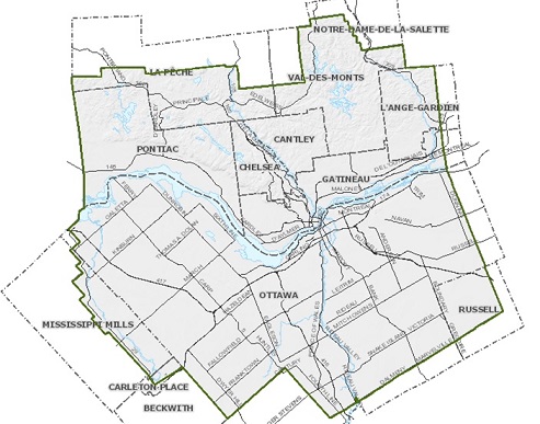
Boundaries of the National Capital Region since 1959, with the coming into force of the National Capital Act
-

A legally defined __Islands Trust__ polygon was drawn from metes and bounds descriptions as written in Letters Patent for the Islands Trust in the province of British Columbia. A polygon dataset that includes all of the administrative areas currently in the __Administrative Boundaries Management System (ABMS)__ is available [here](https://catalogue.data.gov.bc.ca/dataset/legally-defined-administrative-areas-of-bc). A complimentary point dataset that defines the administrative areas is also available available [here](https://catalogue.data.gov.bc.ca/dataset/legally-defined-administrative-areas-of-bc-boundary-locations). Other individual datasets are available from the following records: https://catalogue.data.gov.bc.ca/dataset/local-trust-areas-legally-defined-administrative-areas-of-bc https://catalogue.data.gov.bc.ca/dataset/municipalities-legally-defined-administrative-areas-of-bc https://catalogue.data.gov.bc.ca/dataset/regional-districts-legally-defined-administrative-areas-of-bc https://catalogue.data.gov.bc.ca/dataset/electoral-areas-legally-defined-administrative-areas-of-bc https://catalogue.data.gov.bc.ca/dataset/province-of-british-columbia-legally-defined-administrative-areas-of-bc
-
The __shíshálh Nation__ contains legally defined areas of land within the Province of British Columbia over which the shíshálh Nation exercises self-government, including the administration of resources and services available to its members, as described in the shíshálh Nation Self-Government Act of 1986. This spatial layer contains multipart features. Note that the name of the spatial layer is outdated; after the notification of retirement of the layer has been circulated the dataset will be recreated with the correct name. The source data for the geometry of the parcels was the federal "GeoBase - Aboriginal Lands" dataset, available under OGL - Canada. Parcels were adjusted to match provincial base mapping features, following the metes and bounds descriptions in the Letters Patent. A polygon dataset that includes all of the administrative areas currently in the __Administrative Boundaries Management System (ABMS)__ is available [here](https://catalogue.data.gov.bc.ca/dataset/legally-defined-administrative-areas-of-bc). A complimentary point dataset that defines the administrative areas is also available [here](https://catalogue.data.gov.bc.ca/dataset/legally-defined-administrative-areas-of-bc-boundary-locations). The shíshálh Nation Government District Enabling Act, [RSBC 1996] CHAPTER 416 is available [here.](http://www.bclaws.ca/civix/document/id/complete/statreg/96416_01) Other individual datasets are available from the following records: https://catalogue.data.gov.bc.ca/dataset/province-of-british-columbia-legally-defined-administrative-areas-of-bc https://catalogue.data.gov.bc.ca/dataset/municipalities-legally-defined-administrative-areas-of-bc https://catalogue.data.gov.bc.ca/dataset/regional-districts-legally-defined-administrative-areas-of-bc https://catalogue.data.gov.bc.ca/dataset/electoral-areas-legally-defined-administrative-areas-of-bc https://catalogue.data.gov.bc.ca/dataset/islands-trust-legally-defined-administrative-areas-of-bc https://catalogue.data.gov.bc.ca/dataset/local-trust-areas-legally-defined-administrative-areas-of-bc
-
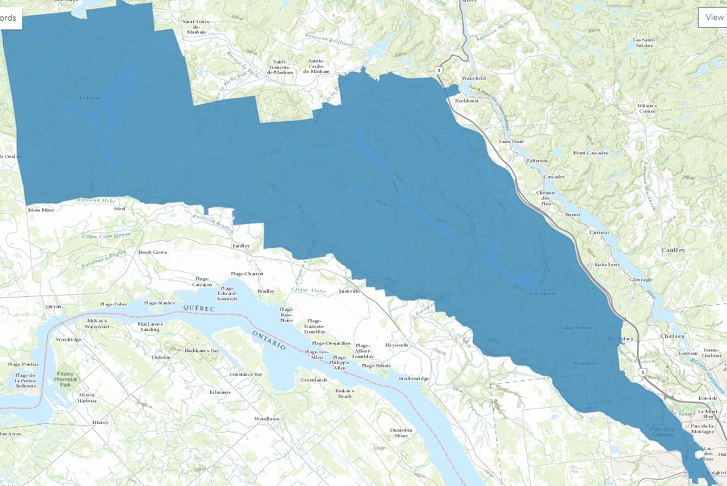
Delimited area of the Gatineau Park as of 2021.
-
This legacy Web Map Services will no longer be maintained on an ongoing basis as of December 31, 2015. It will be removed from operations as of March 31, 2016. To see the latest in DataBC WMS services please go to http://openmaps.gov.bc.ca.
-

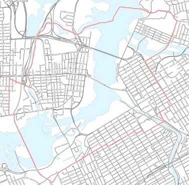
Study area of the Capital Urban Lands Plan as of 2015. https://ncc-ccn.gc.ca/our-plans/capital-urban-lands-plan https://ncc-website-2.s3.amazonaws.com/documents/Capital-Urban-Lands-plan.pdf#page=10
-
Legally defined __Electoral Area__ polygons were drawn from metes and bounds descriptions as written in Letters Patent for Regional District Electoral Areas in the province of British Columbia. In the event of a discrepancy in the data, the metes and bounds description will prevail. Although the boundaries were drawn based on the legal metes and bounds descriptions, they may differ from how regional districts and their member municipalities and electoral areas currently view and/or manage their boundaries. Where discrepancies are noted, the Ministry of Municipal Affairs (the custodian) enters into discussion with the local governments whose boundaries are affected. In order to effect a change to the boundary, Cabinet approval is required. This is done through an Order in Council (OIC). While discrepancies to administrative boundaries are being resolved, boundaries may be adjusted on an ongoing basis until the requested changes are completed. The OIC_YEAR and OIC_NUMBER fields indicate the year that the boundary was passed under OIC and its associated number. The AFFECTED_ADMIN_AREA_ABRVN identifies the administrative areas that are affected by the OIC. A polygon dataset that includes all of the administrative areas currently in the __Administrative Boundaries Management System (ABMS)__ is available [here](https://catalogue.data.gov.bc.ca/dataset/legally-defined-administrative-areas-of-bc). A complimentary point dataset that defines the administrative areas is also available available [here](https://catalogue.data.gov.bc.ca/dataset/legally-defined-administrative-areas-of-bc-boundary-locations). Other individual datasets are available from the following records: https://catalogue.data.gov.bc.ca/dataset/municipalities-legally-defined-administrative-areas-of-bc https://catalogue.data.gov.bc.ca/dataset/regional-districts-legally-defined-administrative-areas-of-bc https://catalogue.data.gov.bc.ca/dataset/province-of-british-columbia-legally-defined-administrative-areas-of-bc https://catalogue.data.gov.bc.ca/dataset/islands-trust-legally-defined-administrative-areas-of-bc https://catalogue.data.gov.bc.ca/dataset/local-trust-areas-legally-defined-administrative-areas-of-bc
-
The __Counties of British Columbia__ contains areas of land within the Province of British Columbia representing legally defined administrative areas described in the County Boundary Act. The purpose of this division is for the administration of justice. The counties were delineated using provincial base mapping features, following the metes and bounds descriptions in the Letters Patent. A polygon dataset that includes all of the administrative areas currently in the __Administrative Boundaries Management System (ABMS)__ is available [here](https://catalogue.data.gov.bc.ca/dataset/legally-defined-administrative-areas-of-bc). A complimentary point dataset that defines the administrative areas is also available [here](https://catalogue.data.gov.bc.ca/dataset/legally-defined-administrative-areas-of-bc-boundary-locations). The Legal document which divides the province of British Columbia into counties is available [here](http://www.bclaws.ca/civix/document/id/complete/statreg/96075_01). Other individual datasets are available from the following records: https://catalogue.data.gov.bc.ca/dataset/province-of-british-columbia-legally-defined-administrative-areas-of-bc https://catalogue.data.gov.bc.ca/dataset/municipalities-legally-defined-administrative-areas-of-bc https://catalogue.data.gov.bc.ca/dataset/regional-districts-legally-defined-administrative-areas-of-bc https://catalogue.data.gov.bc.ca/dataset/electoral-areas-legally-defined-administrative-areas-of-bc https://catalogue.data.gov.bc.ca/dataset/islands-trust-legally-defined-administrative-areas-of-bc https://catalogue.data.gov.bc.ca/dataset/local-trust-areas-legally-defined-administrative-areas-of-bc https://catalogue.data.gov.bc.ca/dataset/sh-sh-lh-nation-legally-defined-administrative-areas-of-bc
-
Legally defined __Local Trust Area__ polygons were drawn from metes and bounds descriptions as written in Letters Patent for the Local Trust Areas in the province of British Columbia. A polygon dataset that includes all of the administrative areas currently in the __Administrative Boundaries Management System (ABMS)__ is available [here](https://catalogue.data.gov.bc.ca/dataset/legally-defined-administrative-areas-of-bc). A complimentary point dataset that defines the administrative areas is also available available [here](https://catalogue.data.gov.bc.ca/dataset/legally-defined-administrative-areas-of-bc-boundary-locations). Other individual datasets are available from the following records: https://catalogue.data.gov.bc.ca/dataset/islands-trust-legally-defined-administrative-areas-of-bc https://catalogue.data.gov.bc.ca/dataset/municipalities-legally-defined-administrative-areas-of-bc https://catalogue.data.gov.bc.ca/dataset/regional-districts-legally-defined-administrative-areas-of-bc https://catalogue.data.gov.bc.ca/dataset/electoral-areas-legally-defined-administrative-areas-of-bc https://catalogue.data.gov.bc.ca/dataset/province-of-british-columbia-legally-defined-administrative-areas-of-bc