 Arctic SDI catalogue
Indigenous peoples
Type of resources
Available actions
Topics
Keywords
Contact for the resource
Provided by
Formats
Representation types
Update frequencies
status
-
A tribal council is a grouping of First Nations with common interests who voluntarily joined together to provide services to member First Nations. The tribal council geographic location dataset contains the geographic location of all tribal councils in Canada as points as well as basic attributes data. Each tribal council point represents its address as it is registered in Indigenous and Northern Affairs Canada (INAC) Indian Government Support System (IGSS). A connection with the IGSS is in place to ensure that any update to the system is reflected in the attributes data associated with the geography of each tribal council. This dataset is Indigenous Services Canada (ISC) and Crown-Indigenous Relations and Northern Affairs Canada (CIRNAC) official source for Tribal Councils geographic location on maps.
-
The RVI/CVI database is derived from the CanEcumene 3.0 GDB (Eddy, et. al. 2023) using a selection of socio-economic variables identified in Eddy and Dort (2011) that aim to capture the overall state of socio-economic conditions of communities as ‘human habitats’. This dataset was developed primarily for application in mapping socio-economic conditions of communities and regions for environmental and natural resource management, climate change adaptation, Impact Assessments (IAs) and Regional Assessments (RAs), and Cumulative Effects Assessment (CEA). The RVI/CVI is comprised of five sub-indicators: 1) population change, 2) age structure, 3) education levels, 4) employment levels, and 5) real estate values. Index values are based on percentile ranks of each sub-indicator, and averaged for each community, and for three ranked groups: 1) all of Canada, 2) by province, and 3) by population size. The data covers the Census periods of 2001, 2006, 2011 (NHS), 2016, and 2021. The index is mapped in two ways: 1) as ‘points’ for individual communities (CVI), and 2) as ‘rasters’ for spatial interpolation of point data (RVI). These formats provide an alternative spatial framework to conventional StatsCan CSD framework. (For more information on this approach see Eddy, et. al. 2020). ============================================================================================ Eddy, B.G., Muggridge, M., LeBlanc, R., Osmond, J., Kean, C., and Boyd, E. 2023. The CanEcumene 3.0 GIS Database. Federal Geospatial Platform (FGP), Natural Resources Canada. https://gcgeo.gc.ca/viz/index-en.html?keys=draft-3f599fcb-8d77-4dbb-8b1e-d3f27f932a4b Eddy B.G., Muggridge M, LeBlanc R, Osmond J, Kean C, Boyd E. 2020. An Ecological Approach for Mapping Socio-Economic Data in Support of Ecosystems Analysis: Examples in Mapping Canada’s Forest Ecumene. One Ecosystem 5: e55881. https://doi.org/10.3897/oneeco.5.e55881 Eddy, B.G.; Dort, A. 2011. Integrating Socio-Economic Data for Integrated Land Management (ILM): Examples from the Humber River Basin, western Newfoundland. Geomatica, Vol. 65, No. 3, p. 283-291. doi:10.5623/cig2011-044.
-

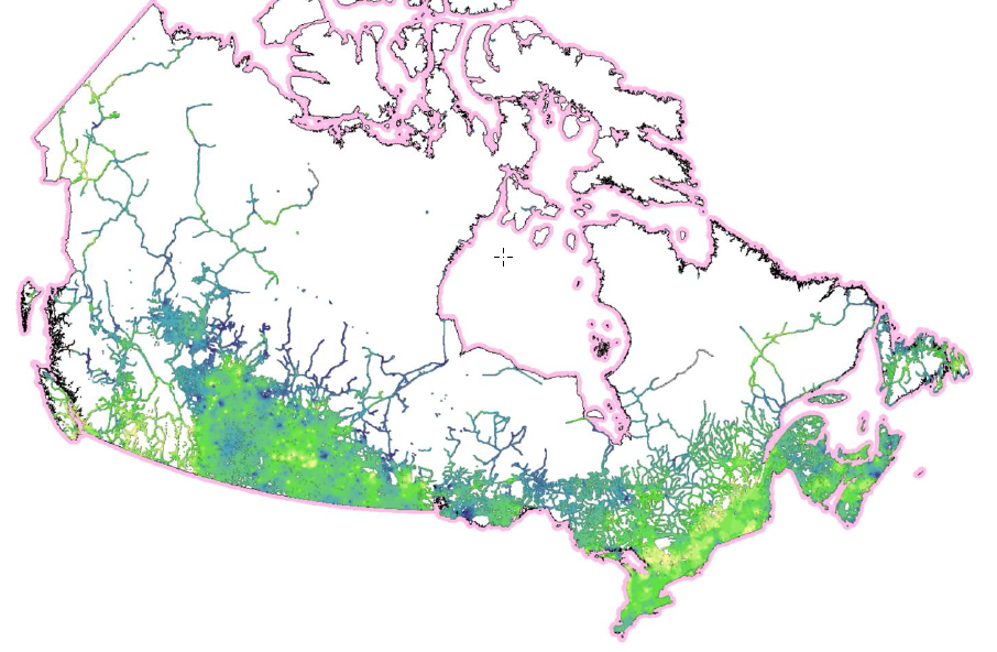
The Labour Force Distribution (LFD) maps are derived from the CanEcumene 2.0 Geodatabase using custom tabulations of census-based labour force data. These LFD maps were calculated for each of the five major natural resource sectors in Canada: Forestry, Fisheries, Agriculture, Minerals, and Petroleum and Coal. The measure used is the labour force of each sector as a proportion of the goods-producing sectors in the economy. Labour force proportions were first calculated at the individual community level, and then interpolated on a regional level using GIS (see Eddy et. al. 2020 for more detail). In effect, these maps show the strong importance of Canada’s natural resource sectors in various regions of the country. The darker the tone in each map indicates a region’s higher degree of dependency on a given sector for their economic livelihood.
-
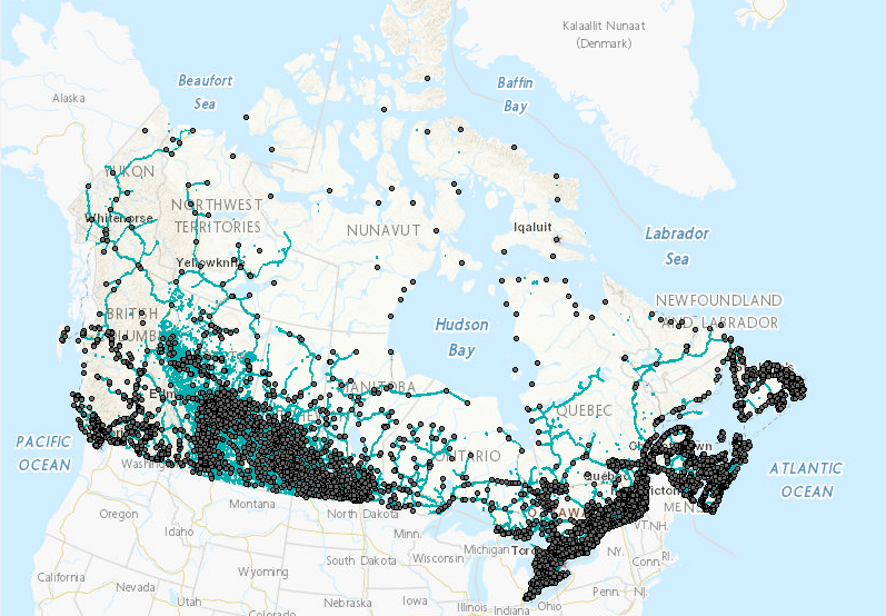
“Ecumene” is a term used by geographers, meaning “inhabited lands.” Populated places in the ecumene database are referenced using natural boundaries, as opposed to administrative or census boundaries, and provide a more suitable means for integrating socio-economic data with ecological and environmental data in a region. The Canadian Ecumene GeoDatabase 3.0 includes the custom boundaries for more than 3,000 populated areas across Canada, many of which were derived from remote-sensing “night-lights” imagery. Each ecumene place has a corresponding set of attributes pertaining to place name, province, ecozone, indigenous communities, and other descriptive information, as well as an initial custom set of demographic variables derived from Statistics Canada Census and National Household Survey data for 2001, 2006, 2011 and 2016. A number of additional layers are also included that map the extents of Canada's ecumene in alternate ways, using transportation and utility networks, nightlights imagery, and population density. (NOTE: In the list below, the V2 Shape, KML, and TIFF files have not changed for the CanEcumene 3.0) Provided layer: The Canadian Ecumene (CanEcumene) 3.0 GIS Database ============================================================================================ Database Citation (Update): Eddy, B.G., Muggridge, M., LeBlanc, R., Osmond, J., Kean, C., and Boyd, E. 2023. The CanEcumene 3.0 GIS Database. Federal Geospatial Platform (FGP), Natural Resources Canada. https://open.canada.ca Methods Publication Citation: Eddy B, Muggridge M, LeBlanc R, Osmond J, Kean C, Boyd E (2020) An Ecological Approach for Mapping Socio-Economic Data in Support of Ecosystems Analysis: Examples in Mapping Canada’s Forest Ecumene. One Ecosystem 5: e55881. https://doi.org/10.3897/oneeco.5.e55881
-

The Indigenous agreements dataset contains geographic boundaries as well as basic attribute data representing arrangements between the Government of Canada, provinces and territories, and Indigenous organizations and communities. These arrangements address Indigenous and northern affairs, such as education, economic development, child and family services, health, and housing, that have not been addressed by treaties or through other means. However, this dataset only contains the Indigenous agreements that have a geographic boundary. The Indigenous agreements dataset includes: 1) Self-government agreements which represents the Indigenous groups that govern their internal affairs and assume greater responsibility and control over the decision making that affects their communities. Self-government agreements address the structure and accountability of Indigenous governments, their law-making powers, financial arrangements and their responsibilities for providing programs and services to their members. Self-government enables Indigenous governments to work in partnership with other governments and the private sector to promote economic development and improve social conditions. These boundaries usually represent the surveyed boundaries of the Indigenous group’s Indian reserve. 2) Consultation agreements (Consultation protocol) which represents an agreement signed between the Indigenous group and one or more parties that establish a consultation process. It sets out an orderly process through which the federal and/or provincial governments can consult with an Indigenous group regarding a contemplated project or activity that may have adverse impacts on established or asserted Aboriginal or Treaty rights. These agreements include Federal Bilateral agreement, Federal Tripartite agreement and other agreements. These boundaries are usually not surveyed but help to delineate the geographic extent of the agreement. 3) Other Agreements is the catch-all category for any remaining geographies of signed agreements between the Indigenous group and other parties, that do not fit within the aforementioned categories. These boundaries are usually not surveyed but help to delineate the geographic extent of the agreement. The Indigenous agreements dataset is one of multiple datasets representing treaties and agreements between the Crown and Indigenous peoples. The Crown-Indigenous treaties and agreements geospatial datasets represent the geographic boundaries of the solemn agreements between the Crown and Indigenous peoples that set out promises, obligations and benefits for parties. The following datasets are also available: 1) The Historic treaties (formerly known as Pre-1975 treaties) dataset, which represents most signed treaties that were negotiated between Indigenous peoples and the Crown between 1725 and 1929. 2) The Modern treaties (formerly known as the Post-1975 treaties) dataset, which represents the areas of Canada where Indigenous land rights and title have not been addressed by preceding treaties or through other legal means. The Indigenous agreements dataset is Crown-Indigenous Relations and Northern Affairs Canada (CIRNAC) and Indigenous Services Canada (ISC)’s primary source for Indigenous agreements geographic boundaries on maps. This dataset can also be viewed in the Aboriginal and Treaty Rights Information System (ATRIS). This web-based system provides access to information to inform governments, industry and other interested parties in determining their consultation obligations and in carrying out their consultation research. For more information, visit https://www.rcaanc-cirnac.gc.ca/eng/1100100014686/1609421785838.
-

The Inuit Communities geographic location dataset contains the geographic location of inhabited and serviced Inuit Communities in Canada as points, as well as data attributes specific to each community. This dataset is Crown-Indigenous Relations and Northern Affairs Canada (CIRNAC) and Indigenous Services Canada (ISC) official source for Inuit Communities geographic location on maps. For more information, visit https://www.rcaanc-cirnac.gc.ca/eng/1100100014187/1534785248701.
-

To support a wide range of efforts to understand the geographic context and historical conditions of the Indian residential schools sites for a wide range of stakeholders, Indigenous Services Canada has created a Web service to access and visualize historical aerial photography for those sites. The Historical aerial photography of Indian residential schools dataset contains digital scans of aerial photographs that were acquired from 1924 to 1998 over Indian Residential school sites and surrounding areas across Canada, as well as basic information about each photography and depicted site. The digital images were georeferenced, to match ground coordinates, saved in a resampled uncompressed raster format and compiled in a single mosaic layer. The dataset does not include the complete range of aerial photographs of each site. Instead, an attempt has been made to select a single optimal photograph for each site based on good photographic quality and the site's years of operation. In some cases no photograph is available, and in others a photograph was only available after the years of operation. The source scanned prints was obtained from the archives of the National Air Photo Library (NAPL) of Natural Resources Canada (NRCAN). This dataset should be considered evergreen as new information and photography sources are identified. It should be noted that this dataset can only be downloaded using ArcGIS and ArcPro software as well as other GIS software.
-

The First Nations geographic location dataset contains the geographic location of First Nations (groups and subgroups) in Canada as points as well as basic attributes data. The location identifies where the First Nations live. Each First Nation point represents its administrative office address as it is registered in Indigenous Services Canada (ISC) Band Governance Management System (BGMS). When the First Nation administrative office is located outside its associated most populated reserve boundary, adjustments are made to relocate the point within its boundaries, otherwise within the boundaries of another associated reserve or the city where the administrative office is located. When the administrative office or the First Nation is impossible to locate, the location is based on the best available information on the First Nation (e.g. official First Nation Web site). A connection with the BGMS is in place to ensure that any update to the system is reflected in the attributes data associated with the location of each First Nation. This dataset is Crown-Indigenous Relations and Northern Affairs Canada (CIRNAC) and Indigenous Services Canada (ISC) official source for First Nation geographic location on maps.
-

The Historic treaties (formerly known as the Pre-1975 treaties) dataset contains geographic boundaries as well as basic attribute data representing signed treaties that were negotiated between Indigenous peoples and the Crown between 1725 and 1929. However, the Treaties of Peace and Neutrality, signed between 1701 and 1760, are not represented in this dataset because they do not have geographic boundaries that can be represented on a map. Apart from the Peace and Friendship Treaties, these boundaries represent the historic treaties signed after 1763, which provided large areas of First Nations land, to the Crown (transferring their Aboriginal title to the Crown) in exchange for reserve lands and other benefits. The Government of Canada recognizes 70 historic treaties in Canada signed between 1701 and 1923. These treaties include: • Treaties of Peace and Neutrality (1701-1760) • Peace and Friendship Treaties (1725-1779) • Upper Canada Land Surrenders and the Williams Treaties (1764-1862/1923) • Robinson Treaties and Douglas Treaties (1850-1854) • The Numbered Treaties (1871-1921) These boundaries are usually not surveyed but help to delineate the broad area described within the treaty. The boundaries are composed of the sum of specific geographies such as lakes, rivers, townships, mountains, administrative boundaries or height of land as mentioned in the treaties transcript. These boundaries are estimated based on written descriptions and should be used for informational and representational purposes only. If there is no geographic description included in the treaty, illustrative polygons may be used to represent locations where the signatory nations, as modern-day collectives, assert and/or exercise Section 35 rights. For more information about Historic treaties, visit https://www.rcaanc-cirnac.gc.ca/eng/1100100028574/1529354437231#chp3. The Historic treaties dataset is one of multiple datasets representing treaties and agreements between the Crown and Indigenous peoples. The Crown-Indigenous treaties and agreements geospatial datasets represent the geographic boundaries of the solemn agreements between the Crown and Indigenous peoples that set out promises, obligations and benefits for parties. The following datasets are also available: 1) The Modern treaties (formerly known as the Post-1975 treaties) dataset, which represents the areas of Canada where Indigenous land rights and title have not been addressed by preceding treaties or through other legal means. 2) The Indigenous agreements dataset, which represents established protocols in place for consultation processes, self-government agreements, and other signed agreements between Indigenous groups and the Crown which do not fall into the aforementioned categories. The Historic treaties dataset is Crown-Indigenous Relations and Northern Affairs Canada (CIRNAC) and Indigenous Services Canada (ISC)’s primary source for Historic treaties geographic boundaries on maps. This dataset can also be viewed in the Aboriginal and Treaty Rights Information System (ATRIS). This web-based system provides access to information to inform governments, industry and other interested parties in determining their consultation obligations and in carrying out their consultation research. For more information, visit https://www.rcaanc-cirnac.gc.ca/eng/1100100014686/1609421785838.
-
The Indigenous Populations of Canada map is derived from the CanEcumene 2.0 Geodatabase using custom tabulations of census-based population data. Indigenous communities within the level of the census sub-division (CSD) were identified using a combination of sources from census field data (see Eddy et. al. 2020 for more details). This map shows the percent of Indigenous population in CanEcumene 2.0 communities using graduated symbols, overlaid upon a population density raster. The larger the symbol, the higher the percentage of Indigenous population in that area. The darker the colour in the underlying raster, the denser is the general population. This map illustrates how the majority of Indigenous populations reside in locations outside of the denser populated areas of Canada.