 Arctic SDI catalogue
Aquatic wildlife
Type of resources
Topics
Keywords
Contact for the resource
Provided by
Years
Formats
Representation types
Update frequencies
status
Service types
-
This dataset was designed for Environment and Climate Change Canada's (ECCC) National Environmental Emergencies Center (NEEC) for oil spill preparedness and response. The polygons from this layer come from the coastal ecosystems geodatabase as part of the Mapping of coastal ecosystems of the Estuary and Gulf of St. Lawrence project. This layer represents semi-vegetated (25-75%) and vegetated (75-100%) zones of which marsh vegetation is the dominant. The study area includes all of the estuarine and maritime coasts of Quebec, with the exception of certain sectors, including most of the Lower North Shore and Anticosti Island, with the exception of villages of Kegaska, la Romaine, Chevery, Blanc-Sablon and Port-Menier. Some islands off the estuary and gulf coasts are part of the region covered, such as Île d'Orléans, Isle-aux-Coudres, Île Verte and Île Bonaventure. The mapping of coastal ecosystems was carried out jointly by the Laboratory for Dynamics and Integrated Coastal Zone Management (LDGIZC) of the University of Quebec at Rimouski as part of the Coastal Resilience Project (https: //ldgizc.uqar.ca/Web/projets/projet-resilience-cotiere) funded by the MELCC; and by the Fisheries and Oceans Canada team, as part of its Integrated marine response planning (IMRP) component of the Oceans Protection Plan (OPP), with the objective of updating the Marine Oil Spill Preparedness and Response Regime of Canada. The master geodatabase of coastal ecosystems is hosted and distributed by UQAR on their SIGEC-Web mapping platform: https://ldgizc.uqar.ca/Web/sigecweb The characterization of marshes was mainly carried out using photo-interpretation of RVBI aerial photos acquired by DFO (2015-2020) and oblique photos taken by helicopter acquired by UQAR in 2017. This dataset also includes the information from validation stations visited by UQAR (2018-2020), used to validate and refine the photo-interpretation.
-

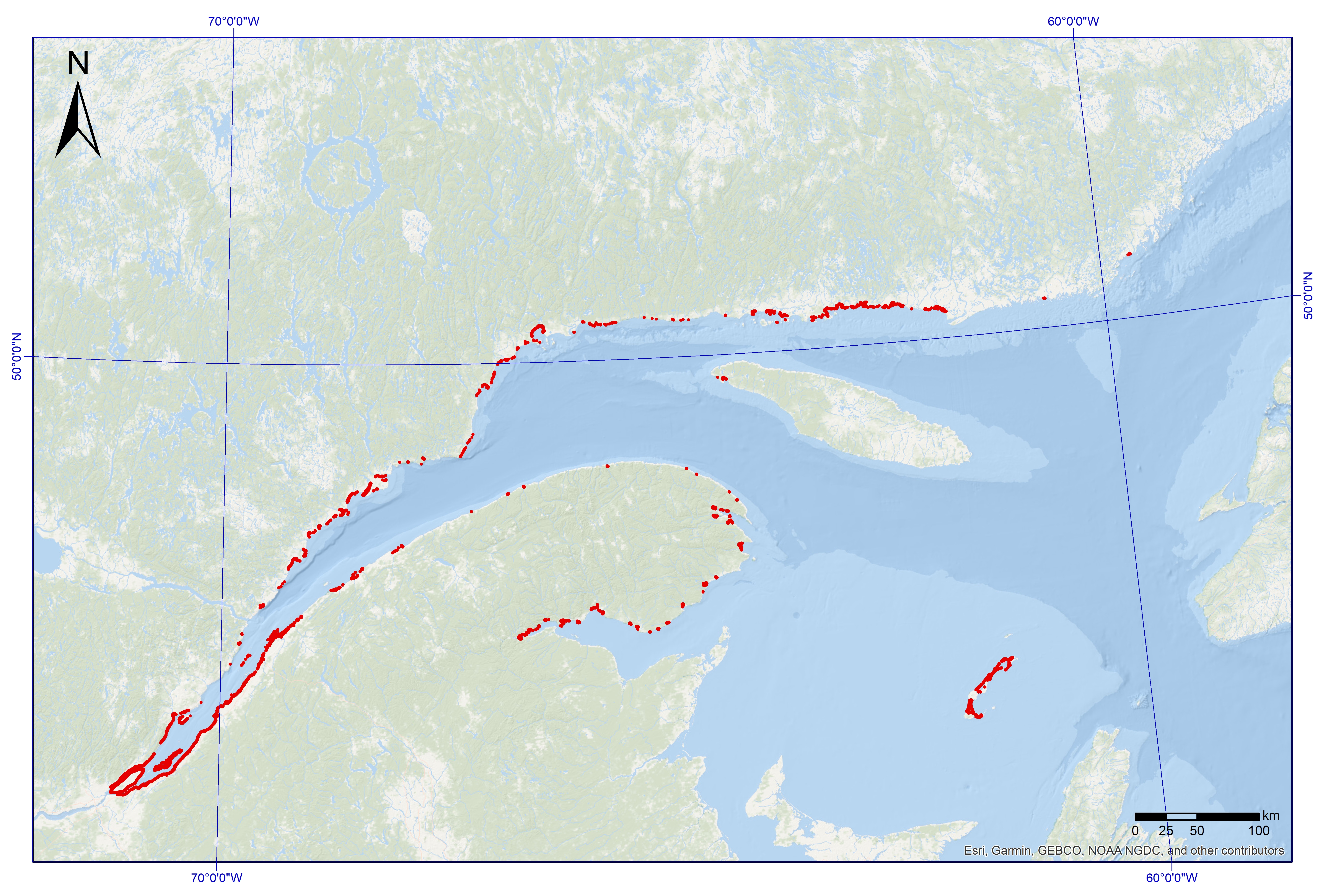
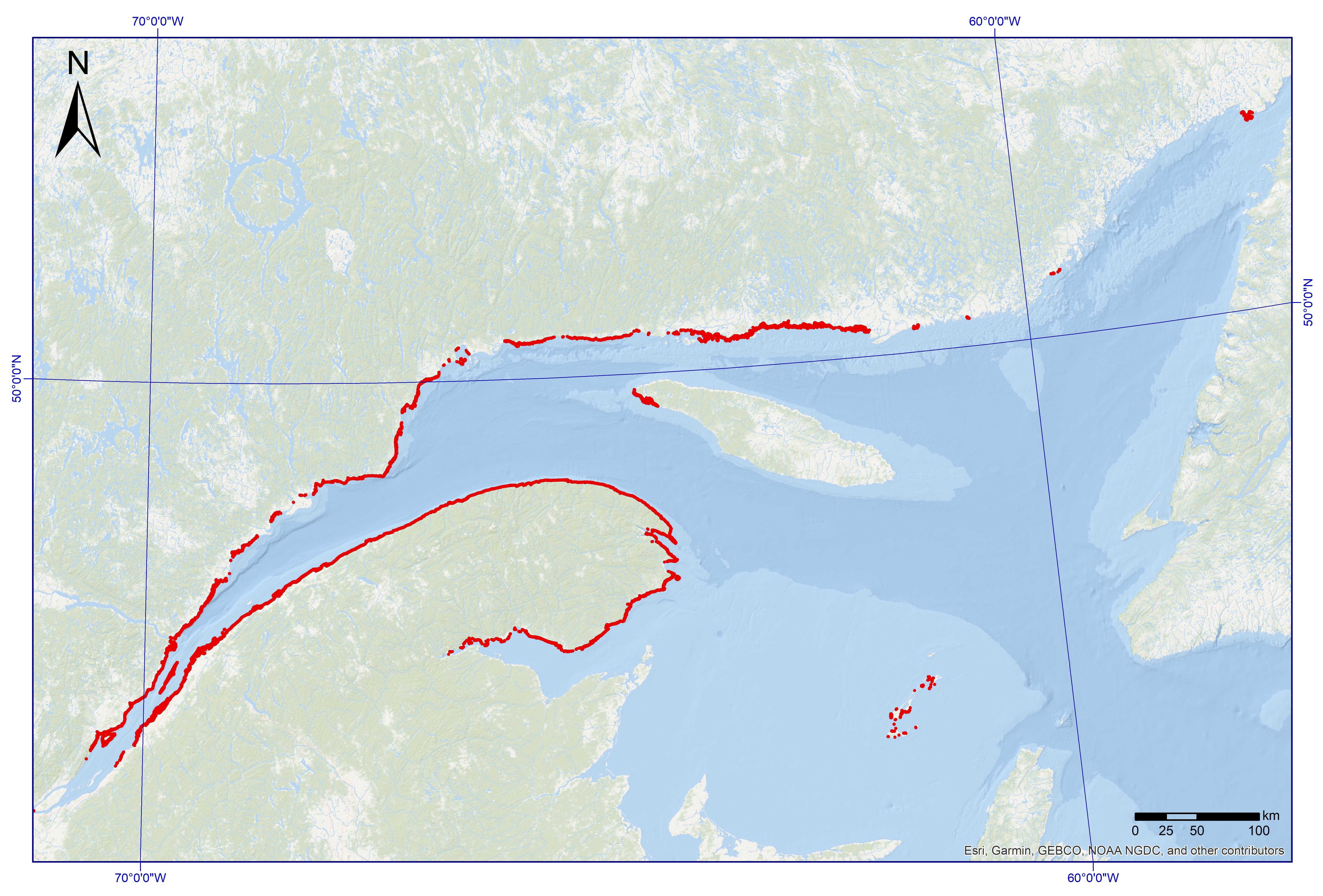
This shapefile dataset was designed using polygons extracted from the Cartography of Coastal Ecosystems of Maritime Quebec geodatabase (2022, Laboratory for Dynamics and Integrated Management of Coastal Zones, Fisheries and Oceans Canada), described in the paragraph below. It consists of polygons with eelgrass and incorporates attributes describing the vegetation cover, the composition of the seagrass beds, the associated ecosystem name, the imagery data that allowed photo-interpretation and the presence or absence of field data. A unique sequence number associated with each polygon makes it possible to trace the paired polygon of the geodatabase of coastal ecosystems to attribute values not detailed in this shapefile. The study area includes all of the estuarine and maritime coasts of Quebec, with the exception of certain sectors, including most of the Lower North Shore and Anticosti Island, with the exception of villages of Kegaska, la Romaine, Chevery, Blanc-Sablon and Port-Menier. Some islands off the estuary and gulf coasts are part of the region covered, such as Île d'Orléans, Isle-aux-Coudres, Île Verte and Île Bonaventure. The Mapping of Coastal Ecosystems of Maritime Quebec was carried out jointly by the Laboratory for Dynamics and Integrated Coastal Zone Management (LDGIZC) of the University of Quebec at Rimouski as part of the Coastal Resilience Project; and by the Fisheries and Oceans Canada team, as part of the Integrated Marine Response Planning Program (IMRP). A classification of coastal ecosystems was carried out on more than 4,200 km of coastal corridor, focusing on estuarine and maritime coasts of Quebec located between the limit of the upper foreshore and the shallow infralittoral (about 10m deep). The mapping method developed is based on semi-automated segmentation and a photo-interpretation of coastal ecosystems, using very high resolution multispectral photographs (RBVI) acquired between 2015 and 2020 by DFO. The classification of polygons is based on the assignment of predefined value classes for the biological and physical attributes under study (e.g., substrates, plant type, vegetation cover, geosystem, etc. ). Helicopter-born oblique photographs and field data helped to reduce the uncertainty associated with photo-interpretation. UQAR and DFO conducted field sampling campaigns targeting the mediolittoral (4,390 stations) and the lower mediolittoral and infralittoral zones (2,959 stations), respectively , which validated some of the attributes identified by photo-interpretation and provided detailed information on community structure . The geodatabase of the Mapping of coastal ecosystems is hosted and managed by UQAR on their SIGEC-Web cartographic platform: https://ldgizc.uqar.ca/Web/sigecweb Credits © DFO (2023, Fisheries and Oceans Canada) Provencher-Nolet, L., Paquette, L., Pitre, L.D., Grégoire, B. and Desjardins, C. 2024. Cartographie des macrophytes estuariens et marins du Québec. Rapp. Tech. Can. Sci. halieut. Aquat. 3617 : v + 99 p. Grégoire, B., Pitre, L.D., Provencher-Nolet, L., Paquette, L. and Desjardins, C. 2024. Distribution d’organismes marins de la zone côtière peu profonde du Québec recensés par imagerie sous-marine de 2017 à 2021. Rapp. tech. can. sci. halieut. aquat. 3616 : v + 78 p. Grégoire, B. 2022. Biodiversité du relevé côtier Planification pour une intervention environnementale intégrée dans l’estuaire et le golfe du Saint-Laurent (2017–2021). Observatoire global du Saint-Laurent. [Jeu de données] Jobin, A., Marquis, G., Provencher-Nolet, L., Gabaj Castrillo. M. J., Trubiano C., Drouet, M., Eustache-Létourneau, D., Drejza, S. Fraser, C. Marie, G. et P. Bernatchez (2021) Cartographie des écosystèmes côtiers du Québec maritime — Rapport méthodologique. Chaire de recherche en géoscience côtière, Laboratoire de dynamique et de gestion intégrée des zones côtières, Université du Québec à Rimouski. Rapport remis au ministère de l’Environnement et de la Lutte contre les changements climatiques, septembre 2021, 98 p.
-
This dataset was designed for Environment and Climate Change Canada's (ECCC) National Environmental Emergencies Center (NEEC) for oil spill preparedness and response. The polygons of this layer were selected from the surface geodatabase of coastal ecosystems from the UQAR-MPO project Mapping coastal ecosystems of the Estuary and Gulf of St. Lawrence. Are represented in this dataset exclusively the polygons whose plant dominance corresponds to a class of macroalgae and presenting a semi-vegetated (25-75%) or vegetated (75-100%) cover. The study area includes all of the estuarine and maritime coasts of Quebec, with the exception of certain sectors, including most of the Lower North Shore and Anticosti Island, with the exception of villages of Kegaska, la Romaine, Chevery, Blanc-Sablon and Port-Menier. Some islands off the estuary and gulf coasts are part of the region covered, such as Île d'Orléans, Isle-aux-Coudres, Île Verte and Île Bonaventure. The mapping of coastal ecosystems was carried out jointly by the Laboratory for Dynamics and Integrated Coastal Zone Management (LDGIZC) of the University of Quebec at Rimouski as part of the Coastal Resilience Project (https: //ldgizc.uqar.ca/Web/projets/projet-resilience-cotiere) funded by the MELCC; and by the Fisheries and Oceans Canada team, as part of its Integrated marine response planning (IMRP) component of the Oceans Protection Plan (OPP),with the objective of updating the Marine Oil Spill Preparedness and Response Regime of Canada. The master geodatabase of coastal ecosystems is hosted and distributed by UQAR on their SIGEC-Web mapping platform: https://ldgizc.uqar.ca/Web/sigecweb The macroalgae characterization was mainly carried out from the photo-interpretation of RGBI aerial photos acquired by the DFO (2015-2020) and oblique helicopter photos acquired by UQAR in 2017. Data from 2959 sampling stations, conducted aboard small boats during DFO field campaigns (2017-2021) were used to detail the nature of algal communities and validate the photo-interpretation. Credits © UQAR-MPO (2023, Laboratoire de dynamique et de gestion intégrée des zones côtières, Pêches et Océans Canada) Provencher-Nolet, L., Paquette, L., Pitre, L.D., Grégoire, B. and Desjardins, C. 2024. Cartographie des macrophytes estuariens et marins du Québec. Rapp. Tech. Can. Sci. halieut. Aquat. 3617 : v + 99 p. Grégoire, B., Pitre, L.D., Provencher-Nolet, L., Paquette, L. and Desjardins, C. 2024. Distribution d’organismes marins de la zone côtière peu profonde du Québec recensés par imagerie sous-marine de 2017 à 2021. Rapp. tech. can. sci. halieut. aquat. 3616 : v + 78 p. Grégoire, B. 2022. Biodiversité du relevé côtier Planification pour une intervention environnementale intégrée dans l’estuaire et le golfe du Saint-Laurent (2017–2021). Observatoire global du Saint-Laurent. [Jeu de données] Jobin, A., Marquis, G., Provencher-Nolet, L., Gabaj Castrillo. M. J., Trubiano C., Drouet, M., Eustache-Létourneau, D., Drejza, S. Fraser, C. Marie, G. et P. Bernatchez (2021) Cartographie des écosystèmes côtiers du Québec maritime — Rapport méthodologique. Chaire de recherche en géoscience côtière, Laboratoire de dynamique et de gestion intégrée des zones côtières, Université du Québec à Rimouski. Rapport remis au ministère de l’Environnement et de la Lutte contre les changements climatiques, septembre 2021, 98 p.
-

PURPOSE: Understanding and predicting species range shifts is crucial for conservation amid global warming. This study analyzes life-history traits of four seal species (ringed (Pusa hispida Schreber, 1775), bearded (Erignathus barbatus Pallas, 1811), harp (Pagophilus groenlandicus Erxleben, 1777), and harbour (Phoca vitulina Linnaeus, 1758) seals) in the Canadian Arctic using data from Inuit subsistence harvests. Bearded seals are largest, followed by harp seals, harbour seals, and ringed seals. Seasonal blubber depth patterns show minimal variation in bearded seals, whereas harbour and ringed seals accumulate fat in open-water seasons and use it during ice-covered seasons. Endemic Arctic seals (ringed and bearded) exhibit greater longevity and determinate body growth, reaching maximum size by 5 years, while harbour and harp seals grow indeterminately, physically maturing around 10-15 years. Age of maturation varies, with ringed and harbour seals being more sensitive to environmental fluctuations. Most bearded seals reproduce successfully each year, while ringed seals exhibit more variability in their annual reproductive success. Analysis of isoprenoid lipids in liver tissue indicates that ringed and bearded seals rely on ice-algal production, whereas harp and harbour seals depend on open-water phytoplankton production. Bearded seals appear more specialized and potentially face less competition, while harp seals may adapt better to changing habitats. Despite expected range shifts to higher latitudes, all species exhibit tradeoffs, complicating predictions for the evolving Arctic environment. DESCRIPTION: This dataset contains the data reported in Steven H. Ferguson, Jeff W. Higdon, Brent G. Young, Stephen D. Petersen, Cody G. Carlyle, Ellen V. Lea, Caroline C. Sauvé, Doreen Kohlbach, Aaron T. Fisk, Gregory W. Thiemann, Katie R. N. Florko, Derek C. G. Muir, Charmain D. Hamilton, Magali Houde, Enooyaq Sudlovenick, and David J. Yurkowski. 2024. A comparative analysis of life-history features and adaptive strategies of Arctic and subarctic seal species - who will win the climate change challenge? Canadian Journal of Zoology 2024-0093.R1 The data set includes species, location, harvest date, sex, age, standard length, girth, fat depth, teste size, parity status, pregnancy status, corpora lutea (n), corpus albicans (n), follicles (n). This dataset includes raw, unfiltered, and unprocessed historical data provided by harvesters that have not been screened for outliers. Individual users should screen the data for their specific use. Cite these data as: Steven H. Ferguson, Jeff W. Higdon, Brent G. Young, Stephen D. Petersen, Cody G. Carlyle, Ellen V. Lea, Caroline C. Sauvé, Doreen Kohlbach, Aaron T. Fisk, Gregory W. Thiemann, Katie R. N. Florko, Derek C. G. Muir, Charmain D. Hamilton, Magali Houde, Enooyaq Sudlovenick, and David J. Yurkowski. 2024. Arctic and Aquatic Research Division, Fisheries and Oceans Canada, Winnipeg, MB. https://open.canada.ca/data/en/dataset/ea9ff038-8b16-11ef-8cce-55cc7f028297
-

The North Shore of the Lower Estuary (Upper North Shore, Quebec) is a productive coastal system where many commercial species of benthic invertebrates are fished in the infralittoral (10-20 m) and circalittoral (20-50 m) zone. However, little data exist on the biodiversity of non-commercial species and the environmental characteristics of the benthic habitat in this area. Two scientific surveys were conducted in 2018 and 2019 to address this knowledge gap by developing a framework of biodiversity and environmental (water column and seafloor) data taking that will be used to determine the baseline state of the benthic ecosystem in this region. Surveys were conducted in 2018 (August 11-14) and 2019 (July 30-August 5) in the Upper North Shore region (between the towns of Forestville and Godbout). Surveys followed a fixed sampling design of eight transects perpendicular to bathymetry with stations at 10 m depth intervals in a bathymetry range of 10-50 m for a total of approximately 40 stations per survey. Specimens were collected with a beam trawl with an opening of 2.8 m. The hauls were made at a target speed of 2 knots and a target duration of 7 minutes. Start and end positions were recorded to calculate the distance traveled on each tow using the geosphere library of R. The average tow distance was approximately 425 m. The area covered at each tow was the product of the trawl opening and the distance traveled. The three files provided (DarwinCore format) are complementary and are linked by the "eventID" key. The "event_information" file includes generic event information, including date and location. The "additional_information_event_and_occurrence" file includes sample size, sampling protocol and sampling effort, among others. The "taxon_occurrence" file includes the taxonomy of the species observed, identified to the species or lowest possible taxonomic level. For abundance and biomass estimates, contact Virginie Roy (virginie.roy@dfo-mpo.gc.ca). For quality controls, all taxonomic names were checked against the World Register of Marine Species (WoRMS) to match recognized standards. The WoRMS match was placed in the "scientificNameID" field of the occurrence file. Special cases were noted in "identificationRemarks" and selected specimens were confirmed using field photos. Data quality checks were performed using the R obistools and worrms libraries. All sampling locations were spatially validated. This project was funded by DFO Coastal Environmental Baseline Program under Canada’s Oceans Protection Plan. This initiative aims to acquire environmental baseline data contributing to the characterization of important coastal areas and to support evidence-based assessments and management decisions for preserving marine ecosystems.
-
A research survey on American lobster (Homarus americanus) has been conducted annually in the Magdalen Islands since 1995 to assess the abundance and structure of lobster populations in this area. Starting in 2007, the main objective was modified to include the diversity and abundance of benthic species associated with lobster habitat. Only benthic species data associated with lobster habitat are presented in this dataset. Surveys were generally conducted during the first two weeks of September from 2007 to 2020 on the entire south side of the Magdalen Islands, from Grosse-Île to Havre-Aubert. The sampling plan consists of 70 trawl tows on 50 fixed stations, between 4 and 35 meters in depth. Some stations had double tows. Specimens were collected using a Nephrops-type door trawl with a total width of 3.04 meters consisting of four Vexar™ lined baskets of 19 millimeter mesh size in order to harvest small individuals. Start and end positions were recorded to calculate the distance traveled at each tow using the geosphere library in R. The year 2011 is not included in the dataset, as biodiversity data were not recorded. Since 2017, the average tow distance has been reduced from 1000 meters to 500 meters. The opening of the trawl is also noted every minute throughout the duration of the tow so that the area sampled can be calculated. The area covered in each tow was the product of the trawl opening and the distance traveled. The two files provided (DarwinCore format) are complementary and are linked by the "eventID" key. The "Event_data" file includes generic activity information, including date and location. The "Occurrence" file includes the taxonomy of the observed species, identified to the species or lowest possible taxonomic level. For abundance and biomass estimates, contact Benoît Bruneau (Benoit.Bruneau@dfo-mpo.gc.ca). For quality controls, all taxonomic names were checked against the World Register of Marine Species (WoRMS) to match recognized standards. The WoRMS match was placed in the "ScientificnameID" field of the occurrence file. Special cases were noted in the "identificationRemarks" field and selected specimens were confirmed with field photos mentioned in "associatedMedia". Data quality checks were performed using the R obistools and WORMS libraries. All sampling locations were spatially validated.
-

A research survey of scallops (mainly sea scallop Placopecten magellanicus, but also Icelandic Scallop Chlamys islandica) using a dredge was carried out by DFO (Fisheries and Oceans Canada) every 1 or 2 years since 1992 in the Magdalen Islands (fishing area 20). The main objective of this research survey was to assess Sea Scallop stocks. Another objective was to document taxa associated with scallop habitat according to a fixed random sampling plan. Occurrences for the year 2021 and 2022 are presented by species (or taxon) by station. Starting in 2021, catches were weighed, and specimens photographed, with information available upon request. The taxonomic and geographical validity of the data was checked and the World Register of Marine Species served as the taxonomic authority for naming all taxa recorded during the survey. Epibenthic invertebrates (mainly molluscs, echinoderms and crustaceans) as well as demersal fish were identified from the dredge catches. The historical dataset is available at the following link : https://open.canada.ca/data/en/dataset/71732ad5-5c70-4dbf-916d-a94e1380c53b The study area is located south of the Magdalen Islands and the sampling of scallop beds is carried out at depths of generally around 25 to 35 m. A random selection of sampling stations is carried out from a fixed station grid. Sampling is done along transects at these randomly drawn stations in the study area. Sampling is done with a lined Digby scallop dredge (20 mm mesh) over approximately 500 m along the seabed. The four baskets of the dredge are examined for all scallops, and starting in 2022, also for all fishes. One basket (first on the starboard side) is sorted and examined for associated species. Most specimens are counted by taxa. Those that are too small and numerous, or colonial, are noted for presence or relative abundance. Special cases are occasionally conserved for taxonomic analysis, for example, ascidians (to monitor for invasive species) and sponges (to document new species). The availability of photos and some conserved specimens enables future review. Changes are anticipated in the identifications, notably for Bryozoan, Hydrozoa, and Porifera, that are currently the focus of research efforts.
-
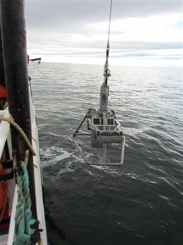
This dataset documents the infauna occurrences collected from 2021 to 2023 during the Canadian Beaufort Sea Marine Ecosystem Assessment (CBS-MEA) conducted by the Department of Fisheries and Oceans (DFO). This scientific program focuses on the integration of oceanography, food web linkages, physical-biological couplings, and spatial and interannual variabilities.The program also aims to expand the baseline coverage of species diversity, abundances, and habitat associations in previously unstudied areas of the Beaufort Sea and Western Canadian Archipelago. The study took place mainly in the Canadian Beaufort Sea and the Amundsen Gulf. Sampling is done along transects at fixed stations in the study area. Catches are collected using a 50 x 50 cm box-corer. 2 or 3 box core is collected per station to obtain replicates. A total of 29 stations were sampled for infauna in 2021, 15 in 2022 and 25 in 2023 between 10-653 m depth. Half of the box corer (0.125 m2) is sampled for infauna taxonomy. The first 20 cm of sediment are collected and sieved through a 0.5 mm mesh sieve. The samples are preserved in seawater-formaldehyde solution (10 % v/v). In the lab, infauna is identified to the lowest taxon level possible. The data are presented in two files: The "Activité_endofaune_CBSMEA_infauna_event_en" file which contains information about missions, stations and deployments, which are presented under a hierarchical activity structure. The "Occurrence_endofaune_CBSMEA_infauna_en" file that contains the taxonomic occurrences.
-

A research survey on snow crab (Chionoecetes opilio) was conducted from May 2006 to May 2009 in the Bay of Ste. Marguerite near Sept-Îles, Quebec. The main objective of this survey was to assess the abundance of snow crab and benthic species associated with snow crab habitat. Only data for benthic species associated with snow crab habitat are presented in this dataset. Data were collected according to a fixed station sampling design consisting of 79 stations, between 7 to 198 meters depth. Specimens were collected using a beam trawl. The codend was lined with a small stretched mesh net in order to harvest the small individuals. The hauls were made at a target duration of 15 minutes. Start and end positions were recorded to calculate the distance traveled on each tow using the geosphere library in R. The two files provided (DarwinCore format) are complementary and are linked by the "eventID" key. The "Activity_Information" file includes generic activity information, including date and location. The "occurrence_taxon" file includes the taxonomy of the species observed, identified to the species or lowest possible taxonomic level. To obtain the abundance and biomass assessment, contact Bernard Sainte-Marie (Bernard.Sainte-Marie@dfo-mpo.gc.ca). For quality controls, all taxonomic names were checked against the World Register of Marine Species (WoRMS) to match recognized standards. The WoRMS match was placed in the "ScientificnameID" field of the occurrence file. Data quality checks were performed using the R obistools and worrms libraries. All sampling locations were spatially validated.
-

A research survey of scallops (mainly sea scallop Placopecten magellanicus, but also Icelandic Scallop Chlamys islandica) using a dredge was carried out by DFO (Fisheries and Oceans Canada) every 1 or 2 years since 1992 in the Magdalen Islands (fishing area 20). The main objective of this research survey was to assess Sea Scallop stocks. Another objective was to document taxa associated with scallop habitat according to a fixed random sampling plan. Occurrences by species (or taxon) are presented by station. The taxonomic and geographical validity of the data was checked and the World Register of Marine Species served as the taxonomic authority for naming all taxa recorded during the survey. Epibenthic invertebrates (mainly molluscs, echinoderms and crustaceans) as well as demersal fish were identified from the dredge catches. The current data starting in 2021 are available at the following link : https://open.canada.ca/data/en/dataset/6529a4b0-f863-4568-ac71-1fa26cf68679 The study area is located south of the Magdalen Islands and the sampling of scallop beds is carried out at depths of 10 to 38 m, generally around 25 to 35 m. A random selection of sampling stations is carried out from a fixed station grid. Sampling is done along transects at these randomly drawn stations in the study area. Sampling is done with a lined Digby scallop dredge (20 mm mesh) over approximately 500 m along the seabed. The four baskets of the dredge are examined for all scallops. Next, a basket (the first on the starboard side) is sorted and examined for associated species. Most specimens are counted by taxon. The presence or relative abundance of undersized and numerous, or colonial, organisms is noted. Special cases are sometimes retained for taxonomic analysis, for example, ascidians (to monitor invasive species) and sponges (to document new species).