 Arctic SDI catalogue
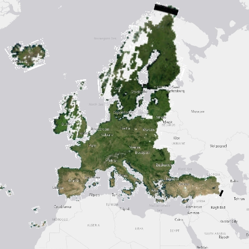
mosaic
Type of resources
Available actions
Topics
Keywords
Contact for the resource
Provided by
Years
Formats
Representation types
Update frequencies
status
Service types
Resolution
-
This wms offers spectacular imagery of the entire province of British Columbia. Orthophoto mosaics, satellite imagery, and hillshaded relief are all available in various pixel sizes from 30m down to one-half metre. Reprojection on-the-fly is also supported
-
This wms offers spectacular imagery of the entire province of British Columbia. Orthophoto mosaics, satellite imagery, and hillshaded relief are all available in various pixel sizes from 30m down to one-half metre. Reprojection on-the-fly is also supported
-
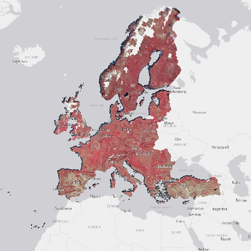
The pan-European High Resolution (HR) Image Mosaic 2006 provides HR2 (High Resolution: 20 meter) coverage over Europe. The surface covered by the image dataset is 5.8 million square kilometres and has a spatial resolution of 20 meters. The imagery is composed during specific acquisition windows between 2005 and 2007. Images are derived from the following satellite sensors: Resourcesat-1 SPOT-4/-5 The mosaic primarily is used as input data in the production of various Copernicus Land Monitoring Service (CLMS) datasets and services, such as land cover maps and high resolution layers on land cover characteristic and can be also useful for CLMS users for visualizations and classifications on land. The input imagery for the creation of the mosaic is provided by ESA. Due to license restrictions, HR Image Mosaic 2006 is only available as a web service (WMS), and not for data download.
-

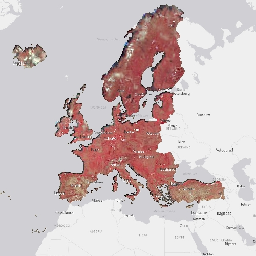
The pan-European Very High Resolution (VHR) Image Mosaic 2018 is a seamless mosaic of the VHR 2018 dataset, based on watershed segmentation of image overlaps. The input data consists of a mix of Pleiades, SPOT, DOVE, Kompsat-4, Deimos-2, SuperView, and TripleSat images. The input imagery has been colour balanced against the Sentinel-2 based HR mosaic from 2018. Colour balancing is done through iterative histogram matching, where the first iteration is used to identify clouds and snow, and the second iteration re-balances, with the bright objects masked out. Cloud cover has been minimized through an innovative approach to cloud masking, which relies on automatically identifying and de-prioritizing overly bright areas in the resulting mosaic. Some clouds and snow remain, as all pixels have to have a value, meaning that if no cloud or snow free images were available for a given area, the bright pixels will remain. The mosaic primarily is used as input data in the production of various Copernicus Land Monitoring Service (CLMS) datasets and services, such as land cover maps and high resolution layers on land cover characteristic and can be also useful for CLMS users for visualizations and classifications on land. The input imagery for the creation of the mosaic is provided by ESA. Due to license restrictions, VHR Image Mosaic 2018 is only available as a web service (WMS), and not for data download.
-

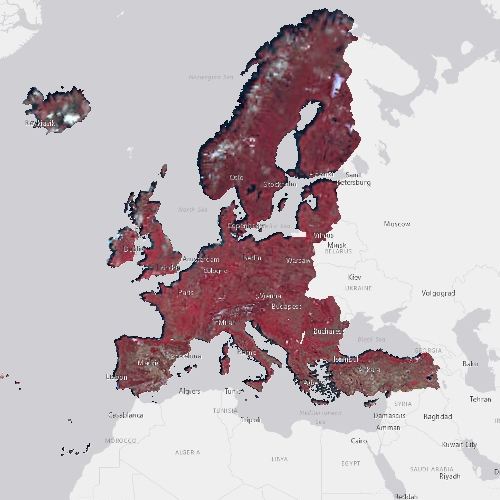
The pan-European High Resolution (HR) Image Mosaic 2015 provides up to two cloud-free HR optical coverage 2 of EEA39 countries including all islands of those countries plus French Overseas Departments (DOMs) acquired within predefined windows corresponding to the vegetation season in 2014-2015. Images are derived from the following satellite sensors: Resourcesat-1/2 SPOT-5 Sentinel-2 MSI The mosaic primarily is used as input data in the production of various Copernicus Land Monitoring Service (CLMS) datasets and services, such as land cover maps and high resolution layers on land cover characteristic and can be also useful for CLMS users for visualizations and classifications on land. The input imagery for the creation of the mosaic is provided by ESA. Due to license restrictions, HR Image Mosaic 2015 is only available as a web service (WMS), and not for data download.
-
Data was created or derived from unmanned aerial vehicle (UAV) imagery acquired from a single day survey, July 28th 2016, in Cambridge Bay, Nunavut. Five control points taken from a Global Differential Positioning System were positioned in the corners and the center of the vegetation survey. The following datasets covers 525m2 and was produced by Canada Centre for Remote Sensing /Canada Centre for Mapping and Earth Observation: - UAV Digital Surface Model (DSM) in Cambridge Bay, Nunavut -Vegetation Plot - UAV Orthomosaic of Cambridge Bay, Nunavut - Vegetation Plot - UAV Vegetation Height Model, Cambridge Bay, Nunavut The UAV survey was completed in collaboration with the Canadian High Arctic Research Station (CHARS) for northern vegetation monitoring research. For more information, refer to our current Arctic vegetation research: Fraser et al; ""UAV photogrammetry for mapping vegetation in the low-Arctic"" Arctic Science, 2016, 2(3): 79-102, 10.1139/as-2016-0008 http://www.nrcresearchpress.com/doi/abs/10.1139/AS-2016-0008
-
The pan-European High Resolution (HR) Image Mosaic 2012 provides HR2 (High Resolution: 20 meter) coverage over Europe. The surface covered by the image dataset is 5.8 million square kilometres and has a spatial resolution of 20 meters. The imagery is composed during specific acquisition windows between 2011 and 2013. Images are derived from the following satellite sensors: Resourcesat-1/-2 SPOT-4/-5 The mosaic primarily is used as input data in the production of various Copernicus Land Monitoring Service (CLMS) datasets and services, such as land cover maps and high resolution layers on land cover characteristic and can be also useful for CLMS users for visualizations and classifications on land. The input imagery for the creation of the mosaic is provided by ESA. Due to license restrictions, HR Image Mosaic 2012 is only available as a web service (WMS), and not for data download.
-
The pan-European High Resolution (HR) Image Mosaic 2006 provides HR2 (High Resolution: 20 meter) coverage over Europe. The surface covered by the image dataset is 5.8 million square kilometres and has a spatial resolution of 20 meters. The imagery is composed during specific acquisition windows between 2005 and 2007. Images are derived from the following satellite sensors: Resourcesat-1 SPOT-4/-5 The mosaic primarily is used as input data in the production of various Copernicus Land Monitoring Service (CLMS) datasets and services, such as land cover maps and high resolution layers on land cover characteristic and can be also useful for CLMS users for visualizations and classifications on land. The input imagery for the creation of the mosaic is provided by ESA. Due to license restrictions, HR Image Mosaic 2006 is only available as a web service (WMS), and not for data download.
-
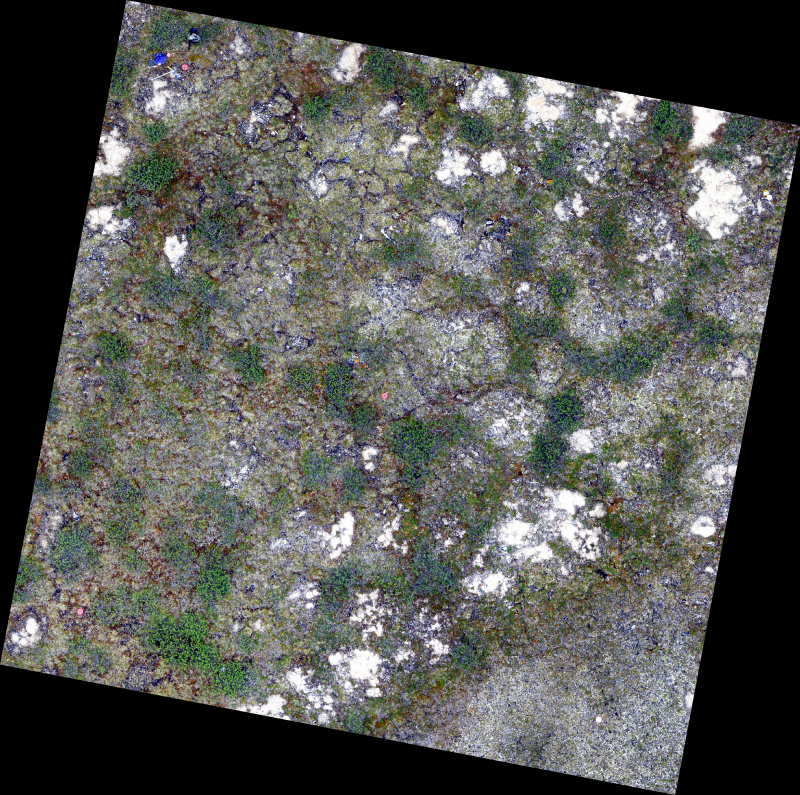
The 0.34 cm resolution orthomosaic was created from unmanned aerial vehicle (UAV) imagery acquired from a single day survey, July 28th 2016, in Cambridge Bay, Nunavut. Five control points taken from a Global Differential Positioning System were positioned in the corners and the center of the vegetation survey. The orthomosaic covering 525m2 was produced by Canada Centre for Remote Sensing /Canada Centre for Mapping and Earth Observation. The UAV survey was completed in collaboration with the Canadian High Arctic Research Station (CHARS) for northern vegetation monitoring research. For more information, refer to our current Arctic vegetation research: Fraser et al; "UAV photogrammetry for mapping vegetation in the low-Arctic" Arctic Science, 2016, 2(3): 79-102. http://www.nrcresearchpress.com/doi/abs/10.1139/AS-2016-0008.
-
The pan-European High Resolution (HR) Image Mosaic 2006 provides HR2 (High Resolution: 20 meter) coverage over Europe for the continuation of Corine Land Cover like exercises and for the generation of HR layers by the EU and EEA. The surface covered by the image dataset is 5.8 million square kilometres and has a spatial resolution of 20 meters. The imagery is composed during specific acquisition windows in 2011, 2012 and 2013. Coverage 2 acquisitions are expected to be 6 weeks away from Coverage 1, down to a minimum of 2 weeks for northern countries, including United Kingdom. The ± 6 weeks criteria might not be strictly applied over Atlantic Islands and French DOMs (seasonal changes are limited in the equatorial DOMs). Images are derived from the following satellite sensors: RapidEye constellation The mosaic primarily is used as input data in the production of various Copernicus Land Monitoring Service (CLMS) datasets and services, such as land cover maps and high resolution layers on land cover characteristic and can be also useful for CLMS users for visualizations and classifications on land. The input imagery for the creation of the mosaic is provided by ESA. Due to license restrictions, HR Image Mosaic 2006 is only available as a web service (WMS), and not for data download.