 Arctic SDI catalogue
trapping
Type of resources
Available actions
Topics
Keywords
Contact for the resource
Provided by
Years
Formats
Representation types
Update frequencies
status
Service types
-

The Province is divided into nine administrative regions, having a total of 225 wildlife management units (WMU) for the purpose of efficient game management.
-

Registered Trapping Concessions (RTCs) are legal boundaries that define an area where the holder of the concession has the exclusive right to trap furbearing animals. Because trapping is done primarily along waterways, RTCs are often defined by watersheds, using height of land (ridges and mountain peaks) as their boundaries. This is the opposite of GMAs which are defined by mountains. Sometimes RTCs are grouped together to form a Group Trapping Concession (in which groups of individual share the right to trap). This may or may not involve the elimination of the component RTC boundaries. The Yukon has 360 RTCs and 13 Group Trapping Concessions. Only Kluane National Park, Kluane Wildlife Sanctuary, and Ddhaw Ghro Habitat Protection are are not covered by RTCs. This data was built using the 1:250,000 National Topographic Data Base (NTDB) as the digitizing base. Distributed from [GeoYukon](https://yukon.ca/geoyukon) by the [Government of Yukon](https://yukon.ca/maps) . Discover more digital map data and interactive maps from Yukon's digital map data collection. For more information: [geomatics.help@yukon.ca](mailto:geomatics.help@yukon.ca)
-
Created for distribution by the GeoYukon application as a comprehensive resource for all publicly available Administrative Boundaries information in the Government of Yukon. This data may be used directly by other applications to dynamically display Yukon data; however, it may be subject to change as data sets are updated or added.
-

These data sets provide information pertaining to shrimp and bycatch estimates associated with beam-trawling and trapping (2001-2002) in Clio Channel. Data sets were compiled and formatted by Meagan Mak. Abstract from report: As part of a project investigating possible modification of marine ecosystems by shrimp trawling and trapping, we enumerated beam trawl and prawn trap catches at two locations in Clio Channel, south -central coast of British Columbia. Beam trawl surveys were conducted in Bones Bay and Turnour Bay during October 2001 and January 2002, respectively, and a prawn trap survey was conducted in Turnour Bay during March 2002. Catch data from the two gear types are presented.
-

The purpose of this dataset is to give an accurate representation of the boundaries of lands closed to hunting in Manitoba. The purpose of this dataset is to give an accurate representation of the boundaries of lands closed to hunting in Manitoba. These are defined as lands where hunting and trapping are either prohibited, or special restrictions are in place for certain species and areas are defined within the General Hunting Regulation (351/87), Moose Conservation Closure Regulation (122/2011), Hunting Seasons and Bag Limits Regulation (165/91), and Trapping of Wild Animals Regulation (245/90) of The Wildlife Act (C.C.S.M c. W130). Hunting and trapping prohibitions or restrictions are implemented in certain areas to ensure the conservation of species or enhance public safety. Fields included (Alias (Field Name): Field description) FID (OBJECTID): Sequential unique whole numbers that are automatically generated Id (Id): The number assigned to each restricted area (not currently being used) Name (Name): Name given to the restricted area Restrictions (Restrictions): Description of the restriction applied to the restricted area Director of Surveys Plan (D_of_S): Director of Surveys Plan number which pertains to the boundary of the restricted area Regulation (Regulation): The regulation title defined in The Wildlife Act Shape_Area (Shape_Area): Area of the feature in internal units squared Shape_Length (Shape_Length): Length of the feature in internal units
-

These data sets provide information pertaining to shrimp and bycatch estimates associated with otter-trawling and trapping (November, 2000) and beam-trawling (February, 2001) in Simoom Sound. Data sets were compiled and formatted by Meagan Mak. Abstract from report: As part of a project investigating possible modification of marine ecosystems by shrimp trawling and trapping, we obtained information on catches offish, shrimp, prawns , and bycatch organisms as well as weight, sex ratios , egg location and colIateral damage to several species of pandalids and eualids. Focusing on the humpback shrimp (Pandalus hypsinotus), we assessed damage to the rostrum, carapace, abdomen, and tail fan on specimens caught by beam trawling, otter trawling, and trapping. Data are given from a preliminary study conducted in Northumberland Channel in June 2000 and more comprehensive sampling from Simoom Sound in November 2000 and February 2001.
-
The purpose of this dataset is to give an accurate representation of the boundaries of lands closed to hunting in Manitoba. The purpose of this dataset is to give an accurate representation of the boundaries of lands closed to hunting in Manitoba. These are defined as lands where hunting and trapping are either prohibited, or special restrictions are in place for certain species and areas are defined within the General Hunting Regulation (351/87), Moose Conservation Closure Regulation (122/2011), Hunting Seasons and Bag Limits Regulation (165/91), and Trapping of Wild Animals Regulation (245/90) of The Wildlife Act (C.C.S.M c. W130). Hunting and trapping prohibitions or restrictions are implemented in certain areas to ensure the conservation of species or enhance public safety. Fields included (Alias (Field Name): Field description) FID (OBJECTID): Sequential unique whole numbers that are automatically generated Id (Id): The number assigned to each restricted area (not currently being used) Name (Name): Name given to the restricted area Restrictions (Restrictions): Description of the restriction applied to the restricted area Director of Surveys Plan (D_of_S): Director of Surveys Plan number which pertains to the boundary of the restricted area Regulation (Regulation): The regulation title defined in The Wildlife Act Shape_Area (Shape_Area): Area of the feature in internal units squared Shape_Length (Shape_Length): Length of the feature in internal units
-
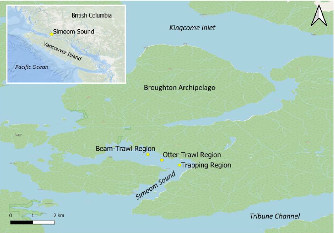
These data sets provide information pertaining to abundant taxa including bottom-dwelling shrimp and fish along trawling and trapping transects in Simoom Sound at November, 2000, and February, 2001. Data sets were compiled and formatted by Meagan Mak. Abstract from report: This study is a component of a larger project designed to compare the effects of shrimp trawling and trapping gear on shrimp, fish and the benthic habitat of Simoom Sound located in Broughton Archipelago, British Columbia, Canada. Otter-trawling, beam-trawling, and trapping took place in three distinct experiment blocks of the central seabed of the Sound. In turn, each block consisted of replicate transects, where a towed submersible video-camera surveyed shrimp and fish before and after trawling. Video surveys were deployed only before trapping. From the video surveys, we determined the abundance of common shrimp taxa and fish.
-

A trapline area is a polygon feature that identifies a ministry-regulated boundary used to administer traplines and fur management programs.