Beaufort Sea
Type of resources
Available actions
Topics
Keywords
Contact for the resource
Provided by
Years
Formats
Representation types
Update frequencies
status
Service types
-

This record contains two datasets: 1. Raw unfiltered geographic coordinates and accuracy estimates of ringed seals tagged in the Western Canadian Arctic and 2. The location estimate from state-space models using a 12-hr time step. In total, 17 ringed seals were captured, measured, weighed, and tagged with satellite-linked transmitters (SDR-10, SDR-16, SPLASH) in June and July of 1999, 2000, and 2010. The tags, manufactured by Wildlife Computers Ltd. (Redmond, Washington, USA), sent data to polar orbiting satellites. Data were then retrieved via the Argos system (Harris et al., 1990). Tags collected and relayed information on movement (geographic positions) and diving data of the instrumented animals.
-

This record contains two-weekly minimum sea ice concentration images of the Canadian Beaufort Sea at 1.1 km resolution. The dataset originated from the Canadian Ice Service (CIS) Digital Archive weekly regional charts for the western Arctic (See “additional credit” for a link to these data), created by synthesis of remotely-sensed, ship and airborne observations (Fequet, 2005). These vector ice charts were gridded at 1.1 km resolution and aggregated into two-week composites by calculating the minimum sea-ice concentration at each grid cell over each two-week interval in each year. Week numbers were defined using the ISO 8601 convention, and sea-ice concentration isrepresented in tenths (with 0/10 corresponding to an ice-free pixel, ranging to 10/10 corresponding to 100% pixel coverage with sea-ice). The result is 12 composite images per year in 1998 through 2020 (23 years), corresponding to https://open.canada.ca/data/en/dataset/ee27e86f-7b18-4e3f-8444-0c5efb6110a4. For further details, see Galley et al., 2022.
-

This record contains data on beluga whale locations in the Mackenzie estuary reported in Harwood, L.A. and P. Norton (1996). Aerial survey data from the southeast Beaufort Sea, Mackenzie River estuary and west. Amundsen Gulf, July 1992. Canadian Data Report of Fisheries and Aquatic Sciences No. 964
-
PURPOSE: Eastern Beaufort Sea beluga whales form one of the largest summering aggregations of the species in the Mackenzie Estuary. In 2010, the Tarium Niryutait Marine Protected Area (TNMPA) was designated to protect beluga whales and their habitats As a part of ongoing ecological monitoring efforts in the TN MPA, passive acoustic monitoring (PAM) was implemented in 2011 to act as continuous monitoring method, filling the temporal gaps associated with historical aerial surveys. Beginning in 2014, PAM effort increased each year, and oceanographic sensors were added to moorings to (1) better understand oceanographic conditions within the TN MPA and (2) examine the environmental parameters that drive beluga movement and habitat use patterns within the estuary. Several studies using this dataset have been completed, and others are ongoing. However, much more can be done with the acoustic and environmental data. The purpose of this report is to outline deployment methods and instrument settings for moorings to support the full use of the data collected. DESCRIPTION: Each summer, Eastern Beaufort Sea beluga whales form one of the largest aggregations of the species in the Mackenzie Estuary. In 2010, the Tarium Niryutait Marine Protected Area (TNMPA) was designated in the estuary to protect beluga whales and their habitats. As a part of ongoing ecological monitoring efforts in the TN MPA, passive acoustic monitoring (PAM) was implemented in 2011 to act as continuous monitoring method, filling the temporal gaps associated with historical aerial surveys. Beginning in 2014, PAM effort increased each year, and oceanographic sensors were added to each PAM mooring to (1) better understand oceanographic conditions (i.e., temperature, salinity, turbidity, and wave conditions) within the TN MPA and (2) to examine the environmental parameters that drive beluga movement and habitat use patterns within the estuary. Moorings have been deployed with varying configurations of oceanographic sensors in Kugmallit Bay since 2015, but typically record water temperature, salinity, depth, and wave conditions. In 2018, the program was expanded to the Niaqunnaq parcel of the MPA (Shallow Bay), and in 2021 it was expanded again to the Okeevik parcel of the MPA. These observatories have provided new knowledge about drivers of beluga habitat use in the TN MPA, in particular in Kittigaryuit, but more recently in Niaqunnaq and Okeevik.
-

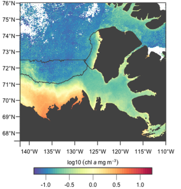
This record contains satellite-sensed chlorophyll-a concentration images of the Canadian Beaufort Sea at 1.1 km resolution. The dataset consists of 276 images, aggregated into two-week composites by calculating the mean value at each pixel, comprising years 1998 through 2020. The dataset spans two ocean colour sensors, MODIS-Aqua and SeaWiFS. The Arctic Ocean Empirical algorithm was used to calculate chlorophyll-a concentration, after images were corrected for atmospheric effects using the NIR-SWIR switching algorithm, and Remote Sensing Reflectance (Rrs) were produced. A linear transform in log-10 space was applied to the chlorophyll-a concentration measured by SeaWiFS to improve its correlation with chlorophyll-a concentration measured by MODIS-Aqua. The months of October through February were excluded from these datasets as the sun angle in winter is too low (e.g., polar night) for reliable data to be acquired, and the region is mostly covered in sea ice. For further details, see Galley et al., 2022.
-

This dataset contains digital data files on transects flown and reported in Harwood, L.A. and P. Norton (1996). Aerial survey data from the southeast Beaufort Sea, Mackenzie River estuary and west. Amundsen Gulf, July 1992. Canadian Data Report of Fisheries and Aquatic Sciences No. 964
-

The objective of this project was to gather data to develop a model of the food web of the lower trophic levels of the nearshore area of the Beaufort Sea. Sampling took place from 2005 to 2008 using the CCGS Nahidik. The multidisciplinary character of the Nahidik program produced measurements of biology/ecology (primary production, phytoplankton, zooplankton, benthos, fish), chemical and physical oceanography, contaminants, geology and hydro acoustics. The data were collected in July and August of each year. The Nahidik program provided data to provide a baseline for future studies as well as an information source for environmental assessment.
-

The Beaufort Regional Environmental Assessment-Marine Fishes Project (2012-2014) and Canadian Beaufort Sea-Marine Ecosystem Assessment (CBS-MEA, 2017-present) conducted by Fisheries and Oceans Canada provide offshore surveys of marine fishes and ecosystems on the Canadian Beaufort Shelf and slope in August and early September. The projects focus on integrating oceanography, food web linkages, physical-biological couplings and spatial and inter-annual variability, within the context of ongoing climate-driven change including enhanced Ocean Acidification. Sampling was conducted from the F/V Frosti at stations along transects spanning 20-1000 m. Zooplankton was collected using a bongo or multi-net system in conjunction with oceanographic and biogeochemical sampling.
-

Situated in the Gwich’in settlement Area (GSA), the Rat River is inhabited by anadromous Dolly Varden (Salvelinus malma malma) that are harvested by both Gwich’in and Inuvialuit beneficiaries. The harvest of Dolly Varden from the Rat River occurs during the summer at feeding areas along the coast (by the Inuvialuit) and during upstream migration in the Mackenzie Delta (by both Gwich’in and Inuvialuit). Dolly Varden stocks are co-managed under an Integrated Fisheries Management Plan (IFMP) whose signatories include Fisheries and Oceans Canada (DFO), Gwich'in Renewable Resources Board, Fisheries Joint Management Committee, and Parks Canada Agency. The Rat River Working Group, the co-management body that makes recommendations for harvest levels for Dolly Varden stocks in the GSA, has supported research activities that facilitate implementation of the IFMP, including studies to monitor harvest levels and assess population status. Population studies (e.g., abundance estimates, biological and genetic sampling) and coastal harvest monitoring activities allow for a comprehensive assessment of this stock. The data are used to inform co-management partners on the status of Dolly Varden from the Rat River.
-

This record contains data on beluga whale locations in the Beaufort Sea and west Amundsen Gulf reported in Harwood, L.A. and P. Norton (1996). Aerial survey data from the southeast Beaufort Sea, Mackenzie River estuary and west. Amundsen Gulf, July 1992. Canadian Data Report of Fisheries and Aquatic Sciences No. 964
 Arctic SDI catalogue