 Arctic SDI catalogue
distribution
Type of resources
Available actions
Topics
Keywords
Contact for the resource
Provided by
Years
Formats
Representation types
Update frequencies
status
Service types
-
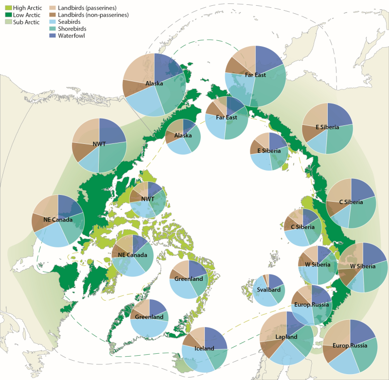
Figure 4.1. Avian biodiversity in different regions of the Arctic. Charts on the inner circle show species numbers of different bird groups in the high Arctic, on the outer circle in the low Arctic. The size of the charts is scaled to the number of species in each region, which ranges from 32 (Svalbard) to 117 (low Arctic Alaska). CAFF 2013. Arctic Biodiversity Assessment. Status and Trends in Arctic biodiversity. Conservation of Arctic Flora and Fauna, Akureyri - Birds (Chapter 4) page 145
-
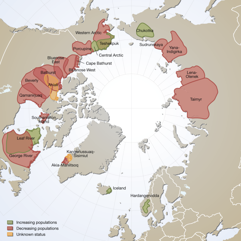
Distribution and observed trends of wild Rangifer populations throughout the circumpolar Arctic (from The Circum Arctic Rangifer Monitoring and Assessment Network, CARMA). Note: Wild boreal forest reindeer have not been mapped by CARMA and thus are not represented here. Published in the Arctic Biodiversity Trends 2010 - Selected indicators of change, INDICATOR #02 - released in 2010
-

Modeled data showing the likely distribution of sea otters. CRIMS is a legacy dataset of BC coastal resource data that was acquired in a systematic and synoptic manner from 1979 and was intermittently updated throughout the years. Resource information was collected in nine study areas using a peer-reviewed provincial Resource Information Standards Committee consisting of DFO Fishery Officers, First Nations, and other subject matter experts. There are currently no plans to update this legacy data.
-
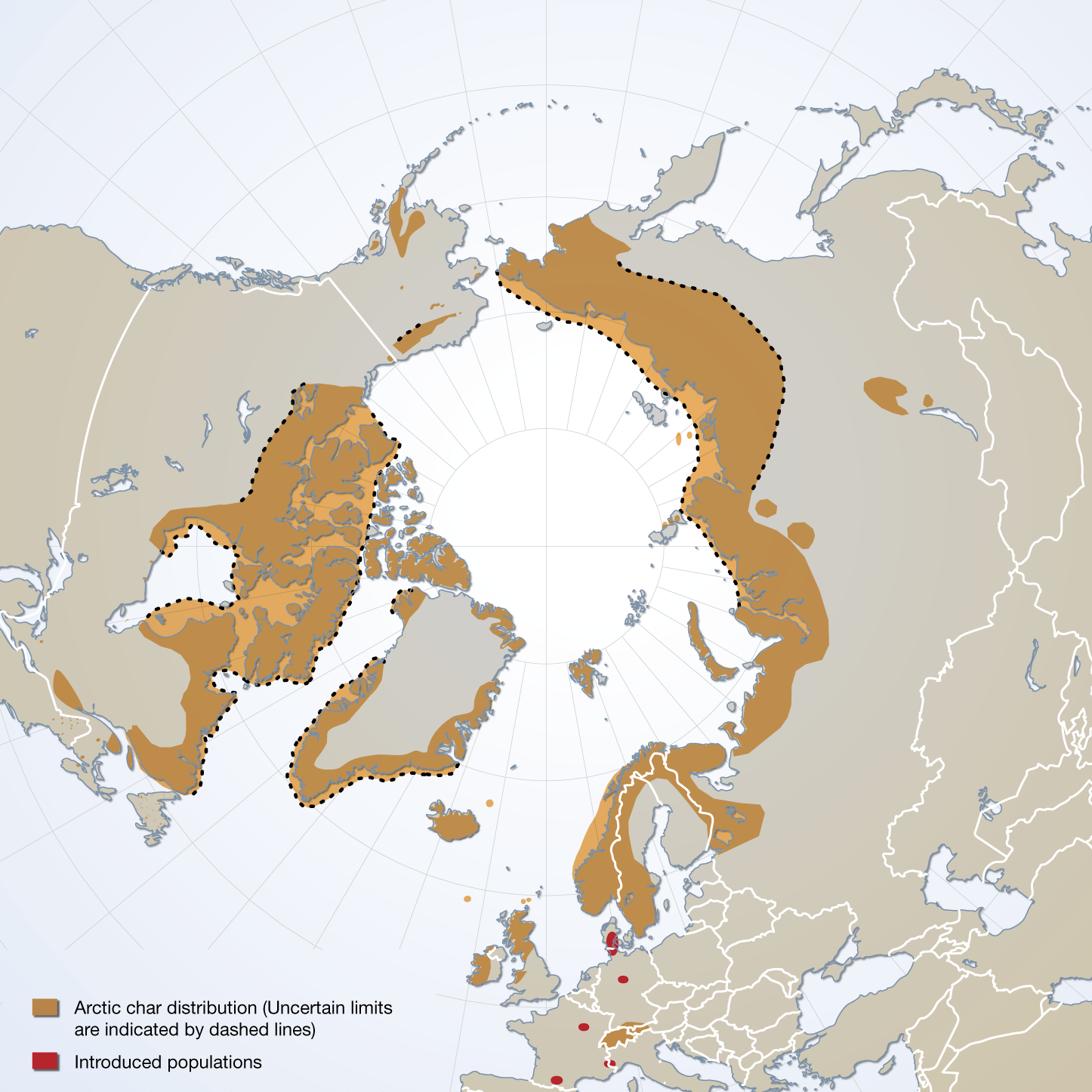
The distribution of Arctic char species complex, sensu stricto, and the location of introduced populations. Published in the Arctic Biodiversity trends 2010, Indicator #06 Arctic char, page 41 - released in May 2010
-
Modeled data showing the likely distribution of steller sealions. CRIMS is a legacy dataset of BC coastal resource data that was acquired in a systematic and synoptic manner from 1979 and was intermittently updated throughout the years. Resource information was collected in nine study areas using a peer-reviewed provincial Resource Information Standards Committee consisting of DFO Fishery Officers, First Nations, and other subject matter experts. There are currently no plans to update this legacy data.
-
Modeled data showing the likely distribution of humpback whales. CRIMS is a legacy dataset of BC coastal resource data that was acquired in a systematic and synoptic manner from 1979 and was intermittently updated throughout the years. Resource information was collected in nine study areas using a peer-reviewed provincial Resource Information Standards Committee consisting of DFO Fishery Officers, First Nations, and other subject matter experts. There are currently no plans to update this legacy data.
-
Modeled data showing the likely distribution of dall's porpoises. CRIMS is a legacy dataset of BC coastal resource data that was acquired in a systematic and synoptic manner from 1979 and was intermittently updated throughout the years. Resource information was collected in nine study areas using a peer-reviewed provincial Resource Information Standards Committee consisting of DFO Fishery Officers, First Nations, and other subject matter experts. There are currently no plans to update this legacy data.
-
Modeled data showing the likely distribution of gray whales. CRIMS is a legacy dataset of BC coastal resource data that was acquired in a systematic and synoptic manner from 1979 and was intermittently updated throughout the years. Resource information was collected in nine study areas using a peer-reviewed provincial Resource Information Standards Committee consisting of DFO Fishery Officers, First Nations, and other subject matter experts. There are currently no plans to update this legacy data.
-
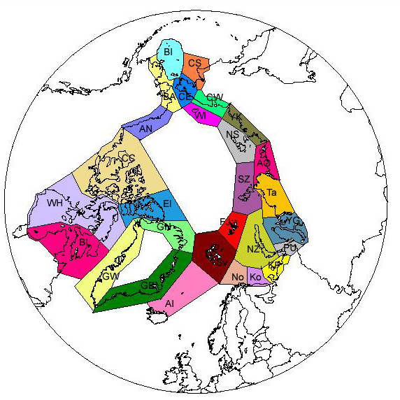
Subdivision of the Arctic into 28 sectors follows mainly the division used in the Pan Arctic Flora (PAF) project. In a few cases some islands are separated from their mainland in the beginning, thus representing very small sectors. Some of them have now been united like in the PAF project, for example Jan Mayen with Arctic Iceland and Bear Island with Svalbard. Others, like the Beringian Islands are still kept separate from the mainland on both sides. - <a href="http://www.caff.is/assessment-series/32-pan-arctic-checklist-of-lichens-and-lichenicolous-fungi" target="_blank"> Pan-Arctic Checklist of Lichens and Lichenicolous Fungi (2011)</a>
-
Modeled data showing the likely distribution of harbour seals. CRIMS is a legacy dataset of BC coastal resource data that was acquired in a systematic and synoptic manner from 1979 and was intermittently updated throughout the years. Resource information was collected in nine study areas using a peer-reviewed provincial Resource Information Standards Committee consisting of DFO Fishery Officers, First Nations, and other subject matter experts. There are currently no plans to update this legacy data.