 Arctic SDI catalogue
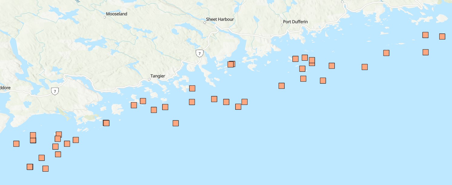
Coastal waters
Type of resources
Available actions
Topics
Keywords
Contact for the resource
Provided by
Formats
Representation types
Update frequencies
status
Resolution
-
Funded under DFO's Marine Conservation Targets Program in partnership with the Huntsman Marine Science Centre (HMSC), this diver-based imagery and sample collection benthic survey documents the occurrence of sponges at 42 dive sites in the Eastern Shore Islands (ESI) Area of Interest (AOI, ~2089 km2) off the Atlantic coast of Nova Scotia, Canada from dive surveys conducted in summer 2021 and 2022. Water quality, species occurrences and counts, habitat, slope, and substrate characteristics were catalogued through diver log sheets, camera imagery, specimen vouchers, and high-resolution bathymetric data. A total of 54 dives to depths from 11 to 33 m (below sea level), collecting up to 147 still images, one-hour of video, and 17 specimen samples per site, resulted in 220 observations for 27 different sponge taxa. This included three new records for Canada (Hymedesmia stellifera, Plocamionida arndti, Hymedesmia jecusculum) and a range extension for a species new to science (Crellomima mehqisinpekonuta) which was recently described from the Bay of Fundy. There were also four species which may seem to be new to science (Halichondria sp., Hymedesmia sp., Protosuberires sp., and Sphaerotylus sp.). Sponges were found to occupy a diversity of micro-habitats, often several different ones in proximity. A total of eight distinct habitat classes were defined, based on varying abundances and diversity of sponges and associated benthic species. These are likely widely distributed among the many complex submerged seabed features within this AOI. Collected specimens were preserved and are stored at the Atlantic Reference Centre (ARC) in St. Andrew's, New Brunswick. Cite this data as: Goodwin, C., Cooper, J.A., Lawton, P., Teed, L.L. 2025. Sponge occurrence and associated species and habitat descriptions derived from the 2021 and 2022 SCUBA diving surveys in the Eastern Shore Islands Area of Interest, Nova Scotia. Version 1.4. Fisheries and Oceans Canada. Occurrence dataset. https://ipt.iobis.org/obiscanada/resource?r=eastern_shore_islands_sponge_survey_2021_2022&v=1.4
-
The MEQ monitoring program is being implemented in 35-40 estuaries in the southern Gulf of St. Lawrence (sGSL) to support the development of a MEQ measure (threshold) to promote efforts to address nutrient enrichment in estuaries. The two main indicators included in the monitoring program are dissolved oxygen and eelgrass coverage which are used to assess the trophic status of estuaries within the region. The two factors most important for impacting the trophic status of estuaries are nitrogen loading and water residence time, i.e., water circulation. If water residence time is long and/or nitrogen loading is high, nutrient impacts are likely. A peer-reviewed manuscript has demonstrated that these two factors are predictive of the dissolved oxygen regime in the upper estuary and that publication successfully used dissolved oxygen to ascribe trophic status to estuaries. In a companion paper it was also determined that nitrogen loading was negatively correlated with eelgrass coverage. These two papers form the basis of the MEQ monitoring program (see attached).
-

Funded under DFO's Marine Conservation Targets Program, this optical imagery benthic survey captured 66 drift-camera transects from September 22, 2023 to October 3, 2024 in the Fundy Isles region of the lower, western Bay of Fundy, New Brunswick, Canada. The survey area includes the 'Head Harbour/West Isles Archipelago/The Passages' Ecologically and Biologically Significant Area (ESBA, ~113 km2), the Wolves Islands and Grand Manan Island. High-resolution still images (n=4695) were taken periodically throughout each transect, while continuous high-definition downward- and forward-facing video (>28 hours of each) was collected simultaneously. Distance travelled and distance between still images (m) was calculated using ArcGIS tools. Field of view (FOV) was estimated by measuring the length and width of a subset of still images (n=343 in year one and n=520 in year two) in ImageJ2, using 10-cm lasers for scale. FOV was standardized for each reported altitude. Transects ranged from 133 m to 2.6 km in length (~44 km surveyed in total), collecting imagery continuously for 3 minutes to more than 1 hour at a time, surveying depths from 15 to 188 m below chart datum. Transect locations were selected based on unique bathymetric features, areas previously predicted to have high habitat suitability for vulnerable marine ecosystem species, as well as proposed areas for inclusion in the regional marine conservation network plan. Cite this data as: Lawton P, Teed L. Near-seafloor drift transect video and high-resolution digital still imagery from a two-year survey in the Fundy Isles region of the lower, western Bay of Fundy. Published February 2025. Coastal Ecosystems Science Division, Fisheries and Oceans Canada, St. Andrews, N.B.
-

This dataset contains the abundance (per m²) and the biomass (mg dry per m²) of macrofauna (≥ 500µm) in eelgrass and adjacent bare soft sediments, collected at sites in the Atlantic of Nova Scotia from 2009 to 2013. Cite this data as: Wong M.C. Data of Benthic invertebrates in seagrass and bare soft sediments in Atlantic Nova Scotia Published May 2020. Coastal Ecosystems Science Division, Fisheries and Oceans Canada, Dartmouth, N.S. https://open.canada.ca/data/en/dataset/05d5f46a-7f19-11ea-8a4e-1860247f53e3 Publications: Wong, M. C., & Dowd, M. (2021). Functional trait complementarity and dominance both determine benthic secondary production in temperate seagrass beds. Ecosphere. 12(11), e03794. https://doi.org/10.1002/ecs2.3794 Wong, M. C. (2018). Secondary Production of Macrobenthic Communities in Seagrass (Zostera marina, Eelgrass) Beds and Bare Soft Sediments Across Differing Environmental Conditions in Atlantic Canada. Estuaries and Coasts, 41, 536–548. https://doi.org/10.1007/s12237-017-0286-2
-

Ocean physical conditions in the Maritimes Region in 2019 were characterized by cooler surface temperatures, continued warmer bottom temperatures and weaker stratification compared to recent years. Deep nutrient inventories were lower than normal over most of the region, with the exception of the Cabot Strait section where deep nutrients were near or higher than normal during the spring sampling and associated with record-warm water. Anomalies of surface nutrients were negative across the region, with the exception of positive anomalies observed at the deep shelf and offshore stations of the Louisbourg section. The spring phytoplankton bloom was near or slightly earlier than normal across the Scotian Shelf (SS) with near-normal duration. Peak chlorophyll a concentrations during the spring bloom occurred within a narrow time window across the SS. At Halifax-2 (HL2), the spring bloom was characterized by a high amplitude, and a rapid progression and decline. Plankton community changes persisted in 2019 with lower abundance of large phytoplankton (diatoms), mainly lower-than-normal biomass of zooplankton and abundance of Calanus finmarchicus, and higher-than-normal abundance of non-copepods. Arctic Calanus and warm-shelf copepods showed mixed abundance anomalies in 2019, reversing the pattern of 2018. Above-normal abundances of Oithona atlantica, especially at HL2, suggest a greater influence of offshore waters in recent years. Surface temperature in the Bedford Basin was near normal in 2019 with mainly cooler-than-normal temperatures from January to June and near- or slightly-above-normal temperatures from July to December. Bottom temperature and salinity were below normal in 2019 with near- or slightly-above-normal conditions at the start of the year and progressing toward cooler and fresher water from February to December. Surface and deep nitrate, phosphate and silicate were near or below normal, with surface phosphate reaching a record low in 2019. The 2018 Continuous Plankton Recorder data indicated an annual abundance of diatoms close to normal for the Eastern (ESS) and Western Scotian Shelf (WSS), while the abundance of dinoflagellates and the Phytoplankton Colour Index values were near (WSS) or above (ESS) normal. The annual abundance of Calanus CI-IV was near normal (ESS) or slightly below normal (WSS), while C. finmarchicus CV-VI levels were slightly below (ESS) or below (WSS) normal. The abundance of Calanus glacialis (ESS, WSS) and Para/Pseudocalanus and Limacina spp. (WSS) were lower than normal, while that of coccolithphore (ESS, WSS), and copepod nauplii and foraminifera (ESS) was higher than normal. "
-

Bay-scale empirical demonstrations of how bivalve aquaculture alters plankton composition, and subsequently ecological functioning and higher trophic levels, are lacking. Temporal, inter- and within-bay variation in hydrodynamic, environmental, and aquaculture pressure limit efficient plankton monitoring design to detect bay-scale changes and inform aquaculture ecosystem interactions. Here, we used flow cytometry to investigate spatio-temporal variations in bacteria and phytoplankton (< 20 µm) composition in four bivalve aquaculture embayments. We observed higher abundances of bacteria and phytoplankton in shallow embayments that experienced greater freshwater and nutrient inputs. Depleted nutrient conditions may have led to the dominance of picophytoplankton cells, which showed strong within-bay variation as a function of riverine vs freshwater influence and nutrient availability. Although environmental forcings appeared to be a strong driver of spatio-temporal trends, results showed that bivalve aquaculture may reduce near-lease phytoplankton abundance and favor bacterial growth. We discuss aquaculture pathways of effects such as grazing, benthic-pelagic coupling processes, and microbial biogeochemical cycling. Conclusions provide guidance on optimal sampling considerations using flow cytometry in aquaculture sites based on embayment geomorphology and hydrodynamics. Cite this data as: Sharpe H, Lacoursière-Roussel A, Barrell J (2024). Monitoring bay-scale bivalve aquaculture ecosystem interactions using flow cytometry. Version 1.2. Fisheries and Oceans Canada. Samplingevent dataset. https://ipt.iobis.org/obiscanada/resource?r=monitoring_bay-scale_bivalve_aquaculture_ecosystem_interactions_using_flow_cytometry&v=1.2
-

This project was completed by the Shellfish Section in the Newfoundland and Labrador Science Branch of Fisheries and Oceans Canada (DFO), in collaboration with industry partners. The Coastal Environmental Baseline program supported the Placentia Bay portion of project work for an ongoing industry-DFO collaborative post-season trap survey for Snow Crab that was initiated in 2003 and has occurred each year. This survey is conducted by Snow Crab harvesters accompanied by at-sea observers and takes place in NAFO Divisions 2J3KLNOP4R. Historically the survey focused on commercial fishing grounds but began transitioning to a partly random stratified design in 2017. Since 2018, approximately 50% of survey stations are randomly allocated while 50% remain fixed. At each station, six (for inshore stations) or ten (for offshore stations) commercial traps are set in a fleet. To gather data on non-commercial sized Snow Crab, including females, many fleets also include one small-mesh trap. The coverage of small-mesh traps has been expanding in recent years with the aim of one small-mesh trap for every station in the coming years. Biological sampling is undertaken on at least one commercial trap and the small-mesh trap at each station. The data from this survey is incorporated into the annual stock assessment for Snow Crab in the Newfoundland and Labrador region. This record contains trap locations for Placentia Bay, and information on the types of data collected. More detailed information can be found in Pantin et al. (2022). https://publications.gc.ca/collections/collection_2023/mpo-dfo/fs70-5/Fs70-5-2022-076-eng.pdf
-

Provinces and Territories Basemap - Canada Provinces basemap file created to generate boundary polygons for use in small scale, medium and large scales. Simple Grey Basemap - This basemap is only in simple grey and white to be used as a backdrop in applications or geomatics projects. Line features represent provincial and territorial boundaries, international boundaries, exclusive economic zones, arcs extending to the North Pole, state boundaries, Canadian, USA and foreign countries rivers. Polygon features representing waterbodies in Canada, USA and foreign countries.
-

This data set is a generalized characterization of the offshore and inshore environments of Canada’s Pacific Ocean. Compiled from various sources to depict the biogenic habitats, pelagic habitats, and general bottom types such as offshore and inshore by depth strata.
-

Funded under DFO's Marine Conservation Targets Program, this two-year optical imagery benthic survey captured 41 drift-camera transects in the St. Anns Bank Marine Protected Area (MPA - 4364 km2) and 4 coastal transects west of the MPA, Atlantic Canada from August 15-23, 2023 and August 08-17, 2024. High-resolution still images (n=3605) were taken periodically throughout each transect, while continuous high-definition downward- and forward-facing video (~20 hours of each) was collected simultaneously along with over 14 hours of forward-facing Go-Pro video (only in 2024). Transect and image locations were collected using an acoustic positioning operating system (Kongsberg APOS) acquired in 2024; year-one of the survey relied on the vessel position. Distance travelled and distance between still images (m) was calculated using ArcGIS tools. Field of view (FOV) was estimated by measuring the length and width of a subset of still images from year-one of the survey (n=500) in ImageJ2, using 10-cm lasers for scale. FOV was standardized for each reported altitude. Transects ranged from 319 m to 2.8 km in length (~47 km surveyed in total), collecting imagery for 12 minutes to just over 1 hour at a time, surveying depths from 17 to 160 m below chart datum. Transect locations were selected based on unique bathymetric features and benthoscapes as well as areas previously surveyed from 2009-2015. Cite this data as: Lawton P, Teed L. Near-seafloor drift transect video imagery and high-resolution digital still images from a two-year survey in support of Marine Protected Area monitoring of St. Anns Bank, Atlantic Canada. Published January 2025. Coastal Ecosystems Science Division, Fisheries and Oceans Canada, St. Andrews, N.B.