 Arctic SDI catalogue
Mapping
Type of resources
Available actions
Topics
Keywords
Contact for the resource
Provided by
Years
Formats
Representation types
Update frequencies
status
Service types
Scale
-

Small area data (SAD) on field crops show seeded and harvested area, yield and production estimates for most principal field crops and some special crops in Canada. Most SAD geographies correspond exactly with the Census Agriculture Region (CAR) limits, excepts for some regions of Quebec (where small areas are defined by provincial administrative boundaries), Saskatchewan (where small areas coincide with census divisions boundaries as of 2017) and British Columbia. For exact correspondence between Census Agricultural Regions (CAR) and Small Area Data (SAD) Regions, see the following link: https://www.statcan.gc.ca/eng/statistical-programs/document/3401_D2_V2 These regions are associated with Statistics Canada estimates on principal field crops available in the following table: https://www150.statcan.gc.ca/t1/tbl1/en/tv.action?pid=3210000201
-
Small area data (SAD) on field crops show seeded and harvested area, yield and production estimates for most principal field crops and some special crops in Canada. Most SAD geographies correspond exactly with the Census Agriculture Region (CAR) limits, excepts for some regions of Quebec (where small areas are defined by provincial administrative boundaries), Saskatchewan (where small areas coincide with census divisions boundaries as of 2017) and British Columbia. For exact correspondence between Census Agricultural Regions (CAR) and Small Area Data (SAD) Regions, see the following link: https://www.statcan.gc.ca/eng/statistical-programs/document/3401_D2_V2
-
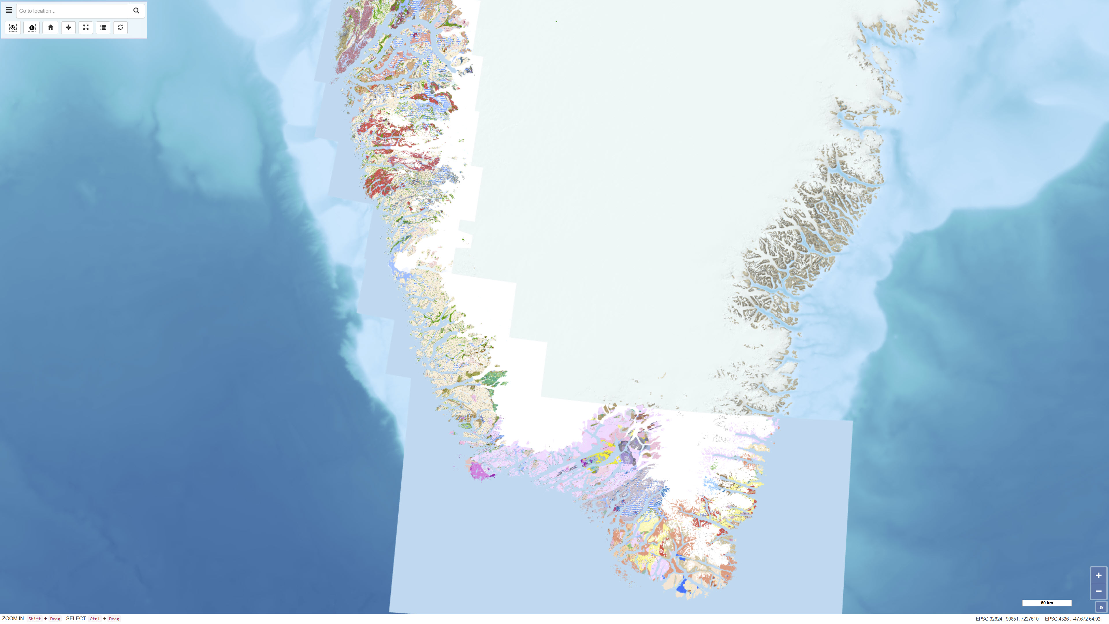
The seamless digital geological map is based on the digitisation and harmonisation of 21 geological map sheets at 1:100 000 scale, originally published by GGU/GEUS between 1966 and 2011. This edition updates and expands the 2019 version, which included 16 sheets, by integrating five additional 1:100 000 sheets and selected information from 1:500 000 scale maps in areas lacking detailed coverage. The map also incorporates a simplified geological interpretation of Bjørneøen and Storeø in Godthåbsfjorden based on detailed mapping by Claus Østergaard (2005). The dataset provides a consistent, seamless geological framework optimised for digital display at the 1:100 000 scale.
-
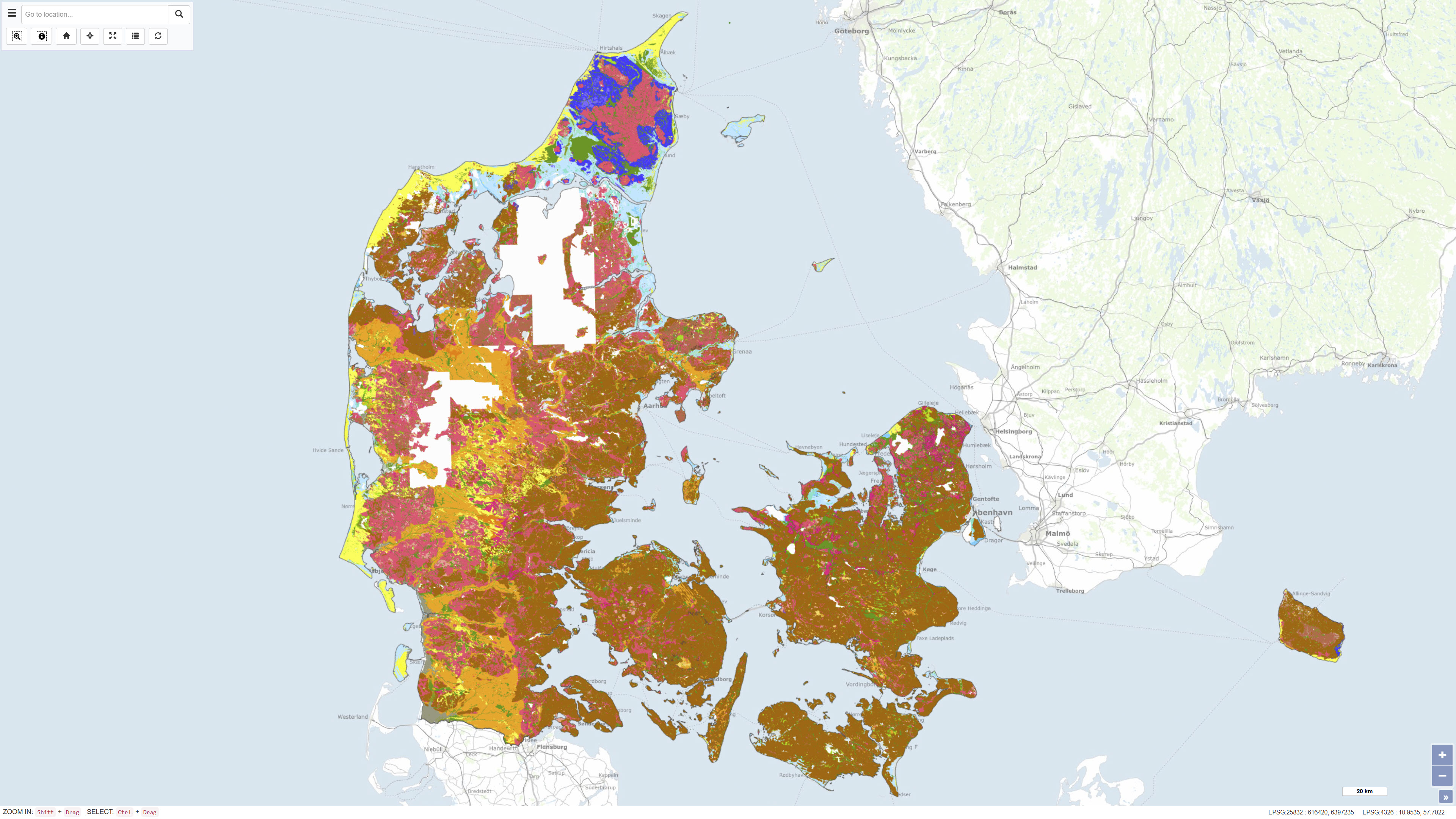
The Digital Geological Map of Denmark 1:25,000, version 7.0, is a nationwide geological dataset describing the distribution of near-surface soil and sediment types across Denmark. The dataset is produced and maintained by the Geological Survey of Denmark and Greenland (GEUS) and represents the latest version of the digital soil and sediment map at a scale of 1:25,000. The map is based on an integrated interpretation of geological field observations, borehole data, historical analogue maps, and more recent digital datasets. Soil and sediment units are classified according to their lithological and genetic characteristics and represent the dominant materials in the uppermost geological layers. The dataset is continuously updated, and version 7.0 includes both revisions of previously mapped areas and newly mapped regions. The dataset is widely used as a foundation for geological analysis, land-use planning, environmental assessment, groundwater protection, raw material management, research, and education. In version 7 from 2023, 93% of Denmark's land area is classified, and the map is continuously supplemented. The map and sediment type description are published in GEUS report 2023/29, where further information is available.
-

This collection is a legacy product that is no longer supported. It may not meet current government standards. Toporama is a digital topographic reference product using CanVec as source data. Developed by Natural Resources Canada (NRCan), Toporama covers the entire area of Canada's landmass and provides symbolic information in a geo-referenced raster format (GeoTIFF). The delimitation, content and representation of this product are similar to those of 1:50,000 scale topographical maps. Toporama is available in the following spatial reference systems: Universal Transverse Mercator (UTM) and geographic (latitude and longitude). Toporama is a product aimed at the general public that can be used by GPS system. The datasets in this collection present the version published in 2013.