Park
Type of resources
Available actions
Topics
Keywords
Contact for the resource
Provided by
Years
Formats
Representation types
Update frequencies
status
Service types
-
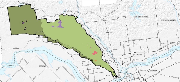
Described in the Gatineau Park Master plan (2021), the land use designations are the authorized activities or uses in a given area. They support the implementation of the park’s vision and goals. They also ensure that interventions and activities are spatially and functionally consistent. https://ncc-ccn.gc.ca/our-plans/gatineau-park-master-plan https://ncc-website-2.s3.amazonaws.com/documents/GPMP_ENG_2021_02_26_Single_Page.pdf#page=65
-
Polygonal layer of parks and green spaces maintained by the municipality. ! [Shawinigan logo] (https://jmap.shawinigan.ca/doc/photos/LogoShawinigan.jpg) **Collection method** Vectorization of cadastral boundaries Fleet name given by the Communications Department **Attributes** * `name` (`char`): Name * `address` (`char`): Civic address * `sector` (`char`): Sector * `pdf` (`char`): * `no_parc` (`char`): Unique identifier * `area` (`integer`): Area * `park_type` (`char`): Park type * `st_area (shape) `(`double`): Surface * `st_length (shape) `(`double`): Perimeter * `objectid` (`integer`): * `old_name` (`char`): For more information, consult the metadata on the Isogeo catalog (OpenCatalog link).**This third party metadata element was translated using an automated translation tool (Amazon Translate).**
-
Mapping of parks offering recreational structures to Quebec City.**This third party metadata element was translated using an automated translation tool (Amazon Translate).**
-

A delimited, open-air space, generally wooded, dedicated to the conservation of an ecosystem or designed for leisure purposes.**This third party metadata element was translated using an automated translation tool (Amazon Translate).**
-
Location of parks and green spaces in the City of Rimouski**This third party metadata element was translated using an automated translation tool (Amazon Translate).**
-

This dataset contains spatial and attribute information for local and regional greenspaces in British Columbia. Local and regional greenspaces are municipal or regional district lands designated by local government agencies and managed for public enjoyment, ecosystem or wildlife values. Spatial boundaries were sourced from municipal and regional district web sites, which in some cases provide datasets under Open Government Licence, and in other cases, publicize parks and greenspaces on web maps or pdf maps. Boundaries were edge-matched to the ParcelMap BC cadastre. This spatial layer contains multipart polygons.
-

The boroughs of the City of Montreal benefit from more than 1,495 parks that extend over an area of more than 6,412 ha. This data set represents all the parks and public spaces identified and illustrates their surface polygons in the context of the urban fabric of the territory. The data is not representative of the parks of the linked cities which are only partially represented. The boundaries of parks and public spaces generally follow the cadastre, but cannot be used as a legal reference to accurately locate the location of a park. The data provided in this data set is for representation purposes only. __Interact with visualization data [View of Montreal's parks and sports facilities] (https://vuesurlesdonnees.montreal.ca/pub/single/?appid=8636bd4b-d2b1-48a0-a790-05331b84af2b&sheet=6bcbf9ba-d7b0-4dfb-a11d-3e075504b5e9).__**This third party metadata element was translated using an automated translation tool (Amazon Translate).**
-

The urban furniture data set in large parks includes a complete inventory of these, most of which was updated in 2013. Among other things, in the form of georeferenced points, they include benches, barbecues, bollards, sports equipment, drinking fountains, trash cans, bike racks, bike racks, picnic tables and some other elements of large parks. The [boundaries of large parks] (/city-of-montreal/grand-parcs-parks-parks-of-boroughs-and-public-spaces) are also available on the portal.**This third party metadata element was translated using an automated translation tool (Amazon Translate).**
-

This dataset includes various offers related to nature and outdoor sports. Among other things, there are national and regional parks, wildlife reserves, equestrian centers, equestrian centers, marinas, skating rinks, beaches, downhill ski centers, cross-country ski centers, golf courses, ice fishing centers. Please note that this dataset is an overview of the tourist offer in Quebec and is not intended to identify the entire offer. This data comes from the Quebec Tourism Information System (SIT Quebec). In addition, if your interest lies in obtaining official indicators and statistics on the Quebec tourism industry, we invite you to explore the Tourism Studies and Statistics section of the Québec.ca site at the following link: https://www.quebec.ca/tourisme-et-loisirs/services-industrie-touristique/etudes-statistiques.**This third party metadata element was translated using an automated translation tool (Amazon Translate).**
-
The distributed PARK feature layer, part of the ISC SaskGIS Cadastral dataset, contains a copy of the PARK feature layer taken from Information Services Corporation's (ISC) geospatial database.
 Arctic SDI catalogue