 Arctic SDI catalogue
Sea regions
Type of resources
Available actions
Topics
Keywords
Contact for the resource
Provided by
Years
Formats
Representation types
Update frequencies
status
Service types
Scale
Resolution
-
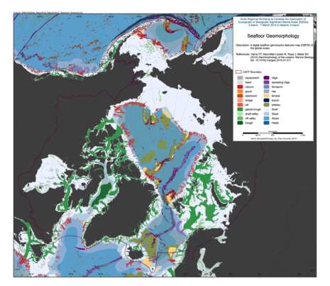
We present the first digital seafloor geomorphic features map (GSFM) of the global ocean. The GSFM includes 131,192 separate polygons in 29 geomorphic feature categories, used here to assess differences between passive and active continental margins as well as between 8 major ocean regions (the Arctic, Indian, North Atlantic, North Pacific, South Atlantic, South Pacific and the Southern Oceans and the Mediterranean and Black Seas). The GSFM provides quantitative assessments of differences between passive and active margins: continental shelf width of passive margins (88 km) is nearly three times that of active margins (31 km); the average width of active slopes (36 km) is less than the average width of passive margin slopes (46 km); active margin slopes contain an area of 3.4 million km2 where the gradient exceeds 5°, compared with 1.3 million km2 on passive margin slopes; the continental rise covers 27 million km2 adjacent to passive margins and less than 2.3 million km2 adjacent to active margins. Examples of specific applications of the GSFM are presented to show that: 1) larger rift valley segments are generally associated with slow-spreading rates and smaller rift valley segments are associated with fast spreading; 2) polar submarine canyons are twice the average size of non-polar canyons and abyssal polar regions exhibit lower seafloor roughness than non-polar regions, expressed as spatially extensive fan, rise and abyssal plain sediment deposits – all of which are attributed here to the effects of continental glaciations; and 3) recognition of seamounts as a separate category of feature from ridges results in a lower estimate of seamount number compared with estimates of previous workers. Reference: Harris PT, Macmillan-Lawler M, Rupp J, Baker EK Geomorphology of the oceans. Marine Geology.
-

Norwegian Download service for INSPIRE Sea Regions.
-
HERMES data in PANGAEA only include meiobenthos abundances at the Arctic Håkon Mosby Mud Volcano (1037 records) and meiobenthos abundances in the Black Sea during Poseidon cruise. HERMES is a multidisciplinary research programme investigating Europe's deep marine ecosystems and their environment. Study sites extend from the Arctic to the Black Sea and include biodiversity hotspots such as cold seeps, cold-water coral mounds and reefs, canyons and anoxic environments, and communities found on open slopes.
-
Happywhale.com is a resource to help you know whales as individuals, and to benefit conservation science with rich data about individual whales. Original provider: Happywhale Dataset credits: Happywhale and contributors Supplemental information: Sightings and images were submitted to Happywhale by contributors. A portion of the Happywhale data were transferred to OBIS-SEAMAP upon the agreement between Happywhale and OBIS-SEAMAP. There may be duplicate records among Happywhale datasets and other OBIS-SEAMAP datasets. The precision of date/time vary per record. Some records have date accuracy up to year only. This dataset includes sightings and photos from the following 14 contributors in alphabetic order: Adelie Xiaohang Li; Alex Sinclair Lack; Greta Henderson; Joel Moore; Karen Mulders; MACHI YOSHIDA; Marian Herz; Marilia Olio; Nacho Oria; Olivier Blaud; Raina Burke; Sabine+Ulf; Sara Jenner; Tobias Brehm
-
Happywhale.com is a resource to help you know whales as individuals, and to benefit conservation science with rich data about individual whales. Original provider: Happywhale Dataset credits: Happywhale and contributors Supplemental information: Sightings and images were submitted to Happywhale by contributors. A portion of the Happywhale data were transferred to OBIS-SEAMAP upon the agreement between Happywhale and OBIS-SEAMAP. There may be duplicate records among Happywhale datasets and other OBIS-SEAMAP datasets. The precision of date/time vary per record. Some records have date accuracy up to year only. This dataset includes sightings and photos from the following 9 contributors in alphabetic order: Anna Astafurova; Barnaby; D Cavagnac; Hans Verdaat; Hondius; Jamie Coleman; Joel Moore; Philip Stone; Pippa Low
-
Happywhale.com is a resource to help you know whales as individuals, and to benefit conservation science with rich data about individual whales. Original provider: Happywhale Dataset credits: Happywhale and contributorsSupplemental information: Sightings and images were submitted to Happywhale by contributors. A portion of the Happywhale data were transferred to OBIS-SEAMAP upon the agreement between Happywhale and OBIS-SEAMAP. There may be duplicate records among Happywhale datasets and other OBIS-SEAMAP datasets. The precision of date/time vary per record. Some records have date accuracy up to year only. This dataset includes sightings and photos from the following 1 contributors in alphabetic order: Marilia Olio
-
Samples of the macrobenthic fauna of soft sediments were collected from around Svalbard during the 1991 Arctic EPOS cruise of RVPolarstern Although faunal variability could be related to sediment granulometry and depth, all stations to the south and east of the Archipelago lay within the broadly defined central Barents Sea community. In this community, (alfa-diversity was variable and sampled between 77 and 337 m showed no clear relationship to depth. Diversity in the area close to the polar front was notably high, rarefaction predicting that 43 ± 5.5 species might occur in a sample of 201 individuals. k-Dominance plots suggested that muddy sand communities around Sval- bard were no less diverse than similar assemblages in the North Sea.
-
This dataset was compiled to describe the intertidal meiobenthic community of Kongsfjorden and to better understand the relationship between the horizontal and vertical distribution of meiofauna with a special focus on nematodes and environmental features
-
Original provider: Happywhale Dataset credits: Happywhale and contributors Abstract: Happywhale.com is a resource to help you know whales as individuals, and to benefit conservation science with rich data about individual whales. Supplemental information: Sightings and images were submitted to Happywhale by contributors. A portion of the Happywhale data were transferred to OBIS-SEAMAP upon the agreement between Happywhale and OBIS-SEAMAP. There may be duplicate records among Happywhale datasets and other OBIS-SEAMAP datasets. The precision of date/time vary per record. Some records have date accuracy up to year only. This dataset includes sightings and photos from the following 0 contributors in alphabetic order:
-
Happywhale.com is a resource to help you know whales as individuals, and to benefit conservation science with rich data about individual whales. Original provider: Happywhale Dataset credits: Happywhale and contributors Supplemental information: Sightings and images were submitted to Happywhale by contributors. A portion of the Happywhale data were transferred to OBIS-SEAMAP upon the agreement between Happywhale and OBIS-SEAMAP. There may be duplicate records among Happywhale datasets and other OBIS-SEAMAP datasets. The precision of date/time vary per record. Some records have date accuracy up to year only. This dataset includes sightings and photos from the following 9 contributors in alphabetic order: Anna Astafurova; Conor Ryan; Johnny Giese; Kerstin Langenberger; Léa Zinsli; Marian Herz; Mick Peerdeman; Rémi Bigonneau; Victoria Stokes