 Arctic SDI catalogue
Lake
Type of resources
Available actions
Topics
Keywords
Contact for the resource
Provided by
Years
Formats
Representation types
Update frequencies
status
Service types
-
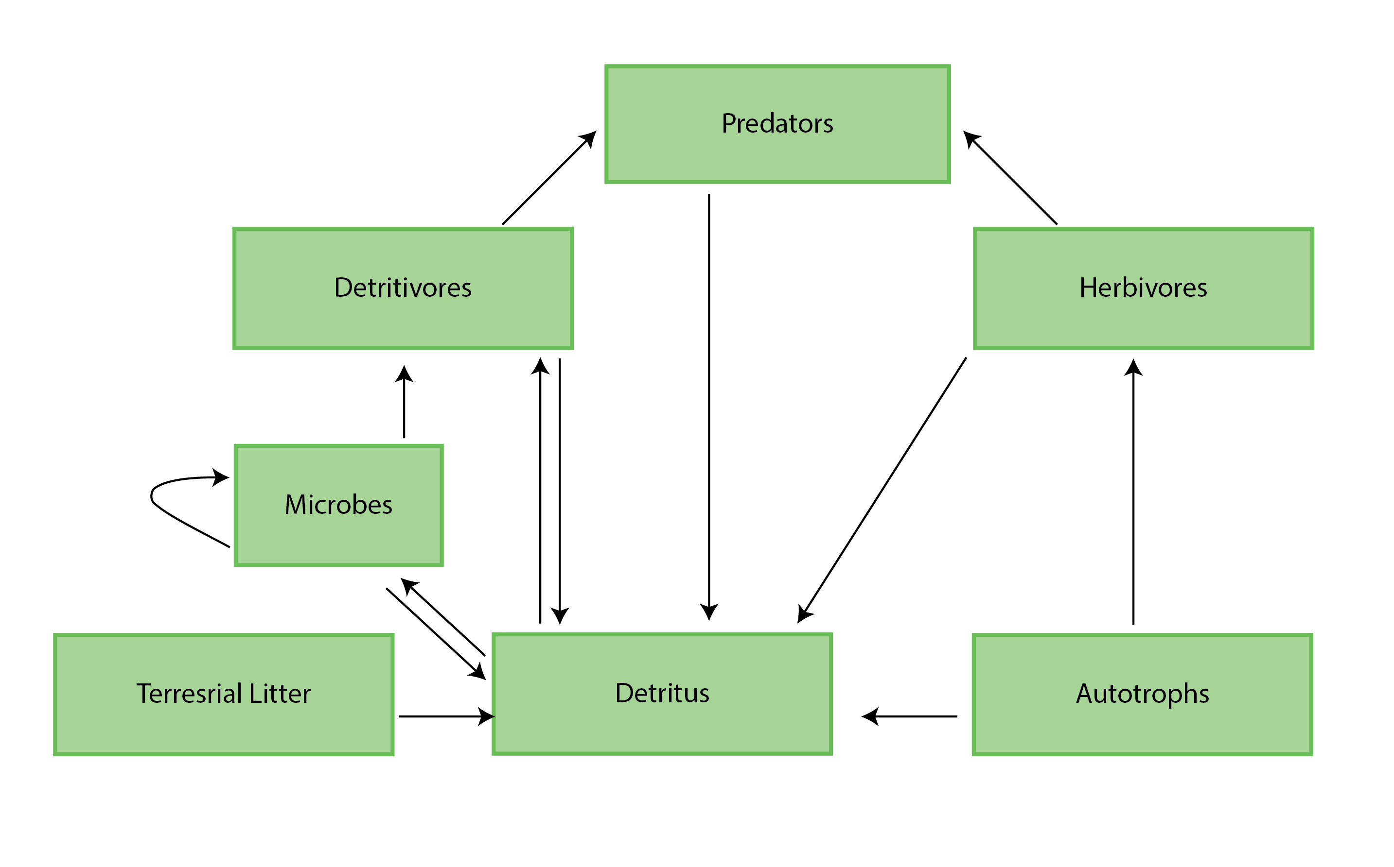
Figure 4-1 A generic food web diagram for a lake or river, indicating the basic trophic levels (boxes) and energy flow (arrows) between those levels. Reproduced from Culp et al. (2012a). State of the Arctic Freshwater Biodiversity Report - Chapter 4 - Page 25 - Figure 4-1
-
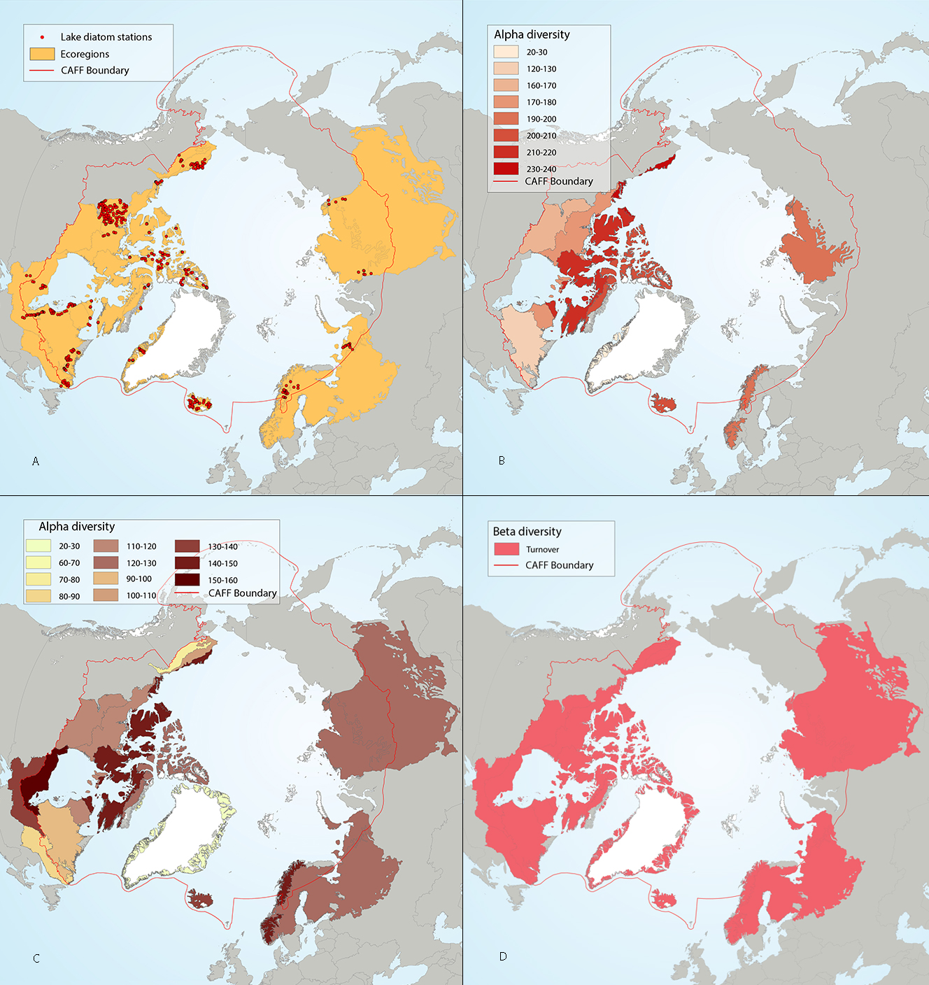
Figure 4-7 Circumpolar assessment of lake diatoms, indicating (a) the location of lake diatom stations, underlain by circumpolar ecoregions; (b) ecoregions with many lake diatom stations, colored on the basis of alpha diversity rarefied to 40 stations; (c) all ecoregions with lake diatom stations, colored on the basis of alpha diversity rarefied to 10 stations; (d) ecoregions with at least two stations in a hydrobasin, colored on the basis of the dominant component of beta diversity (i.e. species turnover, nestedness, approximately equal contribution, or no diversity) when averaged across hydrobasins in each ecoregio. State of the Arctic Freshwater Biodiversity Report - Chapter 4 - Page 35 - Figure 4-7
-
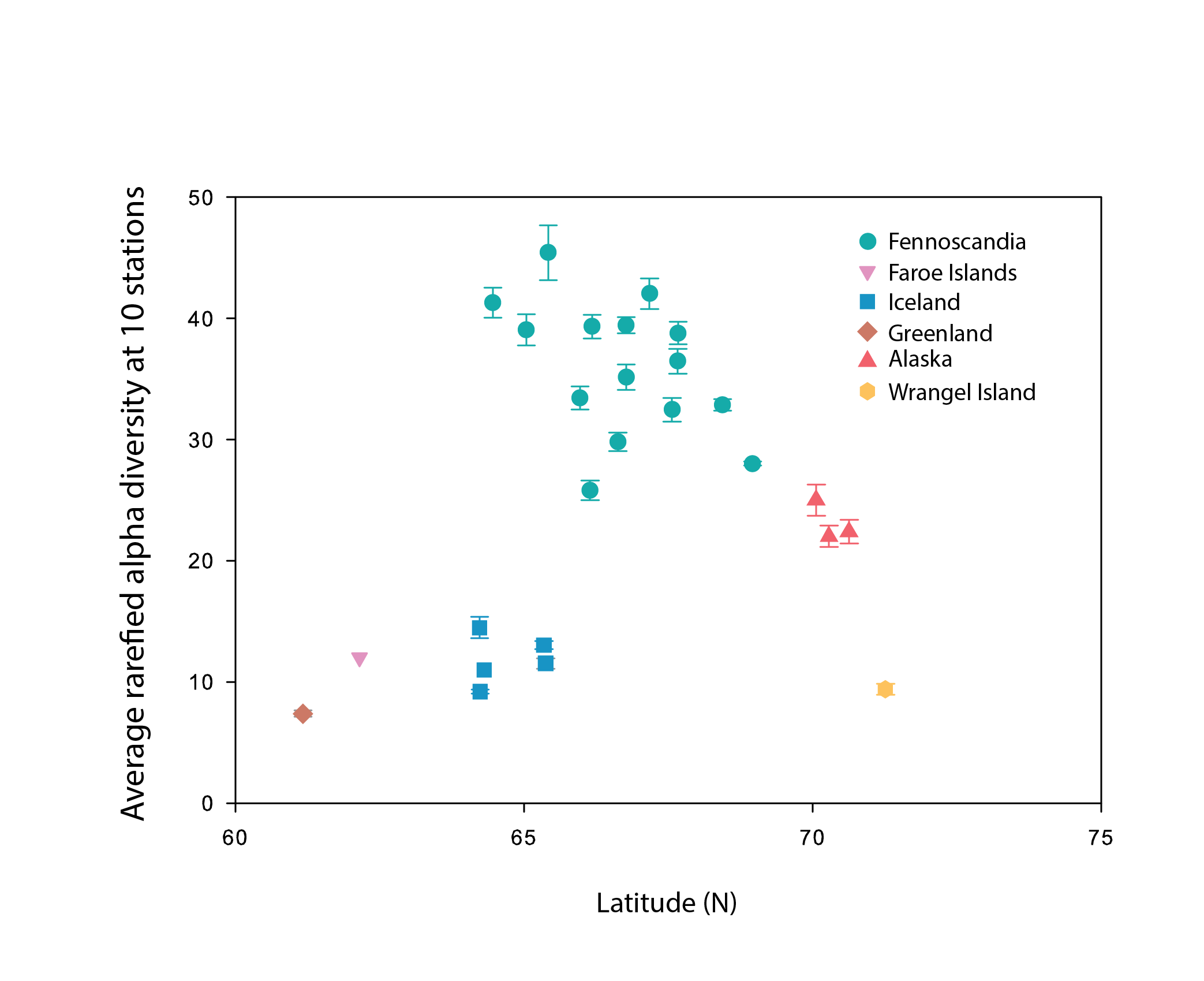
Alpha diversity (rarefied to 10 stations, with error bars indicating standard error) of littoral lake benthic macroinvertebrates plotted as a function of the average latitude of stations in each hydrobasin. Hydrobasins are coloured by country/region. State of the Arctic Freshwater Biodiversity Report - Chapter 4- Page 68 - Figure 4-31
-

The flows and effluent quality data is for the parameters of: * Biological Oxygen Demand BOD5/CBOD5 * Total Suspended Solids (TSS), also described as Residual Particulate Solids * Total Phosphorus (TP) * total monthly flow Keywords: Sewage, Effluent, Discharge, Watershed, Waterworks, Water management, Muncipality
-
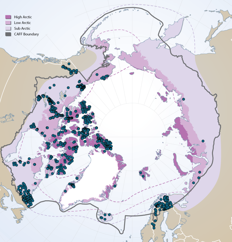
Sites of existing lake biotic and abiotic data as compiled by the Freshwater Expert Monitoring Group (FEMG) of the Circumpolar Biodiversity Monitoring Group (CBMP) Published in the CBMP Freshwater Brochure 2013 https://oaarchive.arctic-council.org/items/e76cce2c-4c87-4eb4-89d3-c88c3ae955d6
-

This dataset contains information on fish stockings since 1917 in Manitoba waterbodies with details on date of stocking, amount of fish, size of fish and species of fish. Stocking Data is a point layer representing individual stocking events dating back to 1917. Each record contains information such as waterbody name, fish species, fish size and quantities, as well as the fishing division of the waterbody. Stocking data is updated multiple times per year as the Province of Manitoba Hatchery conducts stocking. The stocking data layer, along with related information, can be found at the Manitoba Lake Information For Anglers app. The project was initiated by Manitoba Wildlife and Fisheries Branch with funding from the Fish and Wildlife Enhancement Fund. Data is provided by Manitoba Wildlife and Fisheries Branch, Swan Valley Sport Fishing and Manitoba Watershed Districts. For additional information visit Manitoba Fisheries. The dataset includes the following fields (Alias (Name): Description) Waterbody ID (WATERBODY_ID): Unique identifier for an individual waterbody. Waterbody Name (WATERBODY_NAME): Name of the waterbody that was stocked. Fishing Division (FISHING_DIVISION): Indicates which fishing division the waterbody is located in and where stocking event took place. Year (YEAR): Year of the stocking event. Date (DATE): Date of the stocking event. Species (SPECIES): Species that was stocked. Size (SIZE): Size of the fish that were stocked. Quantity (QUANTITY): Approximate number of fish stocked. Lat (DD) (LAT_DD): Latitudinal coordinates of the stocking event (if recorded, otherwise the representative centroid of the waterbody) in decimal degrees. Long (DD) (LONG_DD): Longitudinal coordinates of the stocking event (if recorded, otherwise the representative centroid of the waterbody) in decimal degrees. Waterbody Lat (WATERBODY_LAT): Latitudinal coordinates of the representative centroid of the waterbody in decimal degrees. Waterbody Long (WATERBODY_LONG): Longitudinal coordinates of the representative centroid of the waterbody in decimal degrees.
-
This point layer dataset contains information on Manitoba waterbody access points including boat launches, overland routes and tunnels. Waterbody Entry Points contains point data primarily of boat launches in Manitoba, but it also includes overland routes and tunnel access to some waterbodies. Each data point has a description of the type of access as well as photos that detail signage and condition of the entry point. The waterbody entry points layer, along with related information, can be found at the Manitoba Lake Information For Anglers app. The project was initiated by Manitoba Wildlife and Fisheries Branch with funding from the Fish and Wildlife Enhancement Fund. Data is provided by Manitoba Wildlife and Fisheries Branch, Swan Valley Sport Fishing and Manitoba Watershed Districts. For additional information visit Manitoba Fisheries. The dataset includes the following fields (Alias (Name): Description) Waterbody ID (WATERBODY_ID): Unique identifier for an individual waterbody. Waterbody Name (WATERBODY_NAME): Name of the waterbody that the entry point belongs to. Entry Type (ENTRY_TYPE): Indicates the type of entry point (e.g. boat launch, tunnel). Photo 1 (PHOTO_1): Link to a photo of the launch/entry point. Photo 2 (PHOTO_2): Link to a photo of the launch/entry point. Photo 3 (PHOTO_3): Link to a photo of the launch/entry point. Long (DD) (LONG_DD): Longitudinal coordinates of the feature in decimal degrees. Lat (DD) (LAT_DD): Latitudinal coordinates of the feature in decimal degrees.
-
This point feature layer contains both general and detailed information on waterbodies in Manitoba which are associated with the Lake Information for Anglers program. The point data contained within this layer represent the centroids of waterbodies in Manitoba. The layer describes a number of different attributes about a waterbody including, where available: average depth, aquatic invasive species information, regulatory links, presence of contours, waterbody specific PDF, fish assessment information, species information and coordinates. The waterbody data layer, along with related information, can be found at the Manitoba Lake Information For Anglers app. The project was initiated by Manitoba Wildlife and Fisheries Branch with funding from the Fish and Wildlife Enhancement Fund. Data is provided by Manitoba Wildlife and Fisheries Branch, Swan Valley Sport Fishing and Manitoba Watershed Districts. For additional information visit Manitoba Fisheries. The dataset includes the following fields (Alias (Name): Description) Waterbody ID (WATERBODY_ID): Unique identifier for an individual waterbody. Waterbody Name (WATERBODY_NAME): Name of the waterbody. Surface Area (km2) (SURFACE_AREA): Surface area of the waterbody in square kilometres. Average Depth (m) (AVERAGE_DEPTH_M): Average depth of a waterbody, if bathymetric data is available. Secchi (SECCHI): Indicates whether data exists for secchi depth in the waterbody (YES/NO). Secchi Depth (m) (SECCHI_DEPTH): Depth in meters of the visibility of a secchi disk. Fishing Division (FISHING_DIVISION): Indicates which fishing division the waterbody centroid is within. Fishing Division Special Area (SPECIAL_AREA): Indicates if the waterbody is within the special walleye areas (A or B). Please refer to the Angling Guide for details. UTM Zone (ZONE): Indicates which UTM zone the waterbody is in. Aquatic Invasive Species (AIS): Indicates the known or unknown presence of aquatic invasive species. Aquatic Invasive Species Control Zone (AIS_CONTROL_ZONE): Indicates which aquatic invasive species control zone a waterbody is within. High Quality Management (HIGH_QUALITY_MANAGEMENT): Indicates whether the waterbody falls under the high quality management angling regulations in Manitoba (TRUE/FALSE). HQM Description (HQM_DESCRIPTION): Indicates the high quality management provisions based on the fishing division the waterbody is in (only applies if the waterbody is a High Quality Management waterbody). Angling Regulations (SPECIAL_REGS): A note to see Manitoba Anglers’ Guide. Anglers' Guide (ANGLING_GUIDE): Contains a link (URL) to the Manitoba Anglers’ Guide. Waterbody Link (PRINTABLE_MAP): Contains a link to a PDF of waterbody contours and lake specific information for waterbodies that have bathymetric data. Boat Launch (BOAT_LAUNCH): Indicates whether the waterbody has a known boat launch (YES/NO). Launch Photo (LAUNCH_PHOTO): Indicates whether there is a launch photo for the waterbody (YES/NO). Boat Launch Photo (BOAT_LAUNCH_PHOTO): Contains a link (URL) that directs users to a photo of the launch. Stocked (STOCKED): Indicates whether the lake has been stocked with fish in the past (TRUE/FALSE). Species (SPECIES): A list of gamefish species that are known to have existed in the waterbody historically. Currently contains no info. Assessment (ASSESSMENT): Indicates whether an assessment PDF is available for the waterbody (YES/NO). Fisheries Assessment Link (FISHERIES_ASSESSMENT_LINK): Contains a link that directs users to a PDF document that contains information about species, fish age demographics, and master angler records. Contours (CONTOURS): Indicates whether contour data exists for the waterbody (YES/NO). Lat (DD) (LAT_DD): Latitudinal coordinates of the representative centroid of the waterbody in decimal degrees. Long (DD) (LONG_DD): Longitudinal coordinates of the representative centroid of the waterbody in decimal degrees.
-
The stocking dashboard provides interactive access to Manitoba waterbody information. Filters can be combined to narrow down the waterbodies by: fishing division, waterbody name, fish species, and year stocked. The stocking dashboard is an interface that allows for interactively accessing fish stocking information. It allows filtering and searching for information about stocked lakes. Filters are based on the year of stocking, the fish species stocked, and the fishing division in which the stocking took place. All of these filtering abilities can be compounded to allow users to more effectively find and display information that they are interested in. The dashboard uses the stocking map as its primary tool for users which provides a visual of the filtering options applied. Widgets allow for resetting data to home state view, legend for onscreen features, layers to toggle on and off and ability to change base map options. Additionally there are statistics displayed for total fish stocked, fish stocked in past five years, and fish stocked in the years selected. The latter two statistics are dynamic and update depending on the filters used. This dashboard, along with related information, can be found in the Manitoba Lake Information for Anglers application, an interactive tool for anglers to access waterbody information. The project was initiated by Manitoba Wildlife and Fisheries Branch with funding from the Fish and Wildlife Enhancement Fund. Data is provided by Manitoba Wildlife and Fisheries Branch, Swan Valley Sport Fishing and Manitoba Watershed Districts. For additional information visit Manitoba Fisheries.
-
The nowCOAST 'guidance' Web Map Service (WMS) provides layers containing Forecast Model Guidance visualizations from various oceanographic forecast systems developed by the National Ocean Service and the U.S. Navy. The 'guidance' WMS is one of several map services provided by NOAA's nowCOAST project (http://nowcoast.noaa.gov). For further layer information such as layer icons, legend graphics, layer descriptions, and valid timestamps, see the nowCOAST 'LayerInfo Web Service' description page at: http://nowcoast.noaa.gov/help/layerinfo.shtml. For more information about nowCOAST's available Web Map Services, see the nowCOAST Map Services information page at: http://nowcoast.noaa.gov/help/mapservices.shtml. nowCOAST is a product of the NOAA/NOS/OCS Coast Survey Development Laboratory.