 Arctic SDI catalogue
Statistical units
Type of resources
Available actions
Topics
Keywords
Contact for the resource
Provided by
Years
Formats
Update frequencies
status
Service types
Scale
-

Niðurhalsþjónustur Hagstofunnar
-
Web Map Service providing access to Statistical Units from Agency for Data supply and Efficiency. The content are data from the data sets "DAGI", transformed to the INSPIRE SU vector GML application schema v4.0.
-

Skoðunarþjónustur Hagstofunnar
-
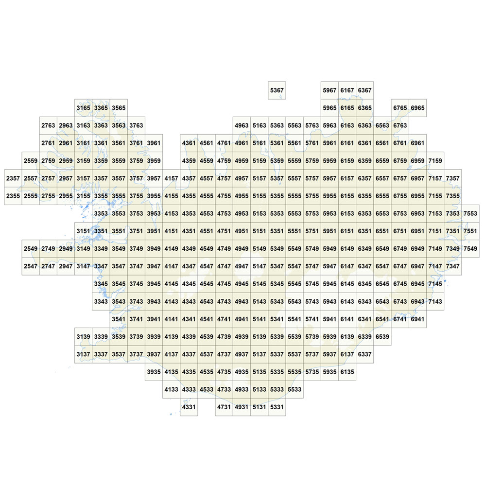
Gagnasafn (GDB) reit_v_20km_VGK50: 20 km reitakerfi fyrir 'Vistgerðakort af Íslandi 1:50.000'. [20 km tiles for 'Habitat Type Map of Iceland 1:50.000']. Reitakerfi og blaðskipting í 20 km (162 hálendis-reita, 176 láglendis-reita). Flákalag og punktalag (hornpunktar). Einkennandi reitanúmer og örnefni á hverjum reit. [Tiles and map sheet index in 20 x 20 km (162 highland-, 176 lowland-tiles). Polygons and corner-points. Specific tile-number and name for each tile.]
-
Gagnasafn (GDB) NI_reitakerfi_v: Reitakerfi fyrir útbreiðslukort lífvera á Íslandi í 10 km og 2 km reitum [10-km- and 2-km-grid to compile distribution maps of organisms in Iceland]. Flákalag og punktalag (miðpunktar). Hver reitur er auðkenndur með 4 tölustöfum þannig að tvær fyrstu tölurnar tilgreina lóðrétta dálkinn en tvær síðustu þann lárétta. [Polygons and center points. The tiles are numberd with a 4 digit code, the first 2 digits name the column, the last 2 digits name the row within this grid.]
-
Gagnasafn (GDB) NI_reit_v_Surtsey_100m: Reitakerfi fyrir útbreiðslukort lífvera á Surtsey í 100 m reitum [100-m-grid to compile distribution maps of organisms on Surtsey]. Sjálfstætt reitakerfi sérstaklega útbúið fyrir rannsóknir í Surtsey. Flákalag og punktalag (hornpunktar). Hver reitur er auðkenndur með tákni þar sem bókstafur vísar til lárétta dálksins og tölustafir til lóðrétta dálksins. [Special grid for research on Surtsey. Polygons and points (corner points). The tiles are numberd with a code, starting with a letter, wich denominates the rows, and ending with a number, which denominates the columns within this grid.]
-

EuroBoundaryMap is a seamless geo-database at the scale 1:100 000 covering 55 countries. It contains geometry, names and codes of administrative and statistical units continuously updated by the members of EuroGeographics, the national mapping and cadastral authorities (NMCAs) of Europe. Updated annually. Datasets in EBM: The EBM dataset was derived from the Icelandic National Database IS 50V, which is at the scale 1:50.000. The generalization has been applied in form of smooth polygon and simplify polygon that ensured the required resolution of the data for the EBM 1: 100 000 scale. The topological relations of the line and area features were ensured. Administrative Units includes: AdministrativeBoundary a line layer containing the demarcations outlining administrative units. AdministrativeUnit_1 a polygon layer containing the national administrative hierarchy, Level 1 (republic). AdministrativeUnit_2 a polygon layer containing the national administrative hierarchy, Level 2 (municipalities). Residence of Authority a point layer containing the administrative centres of all administrative levels. BasicGeometry includes: EBM_A a polygon layer containing administrative areas. Here are the basic components on which administrative units of all hierarchical levels, as well as all statistical layers, are composed. EBM_P a point layer meant for labelling purposes. Label points are located within the main area of the administrative units on lowest level. StatisticalUnits includes: LAU a polygon layer = Local Administrative Unit. NUTS_1 a polygon layer = Nomenclature of Territorial Units for Statistics (whole country) NUTS_2 a polygon layer NUTS_3 a polygon layer = Nomenclature of Territorial Units for Statistics (capital area, rural areas) Tables in EBM: CountryCodes = all countries have unique country codes (icc). EBM_CHR = country codes of those countries where the language is used in alphabetical order delimited by #. EBM_coAdministered = Relationship between administrative unit and its co-administering administrative units on the same hierarchical level. A few countries have special areas with shared administrative units. EBM_ISN = designations of administrative hierarchical levels EBM_NAM = names of administrative units EBM_NUTS = Relationship between the SHN codes of administrative units on lowest national administrative level and corresponding statistical codes.
-

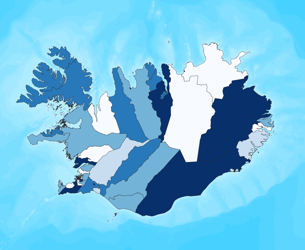
Smásvæði Ísland er dreifbýlt land, en þéttbýlt á höfuðborgarsvæðinu. Hefðbundin skipting landsins í landsvæði og sveitarfélög býður ekki upp á samanburðarhæf svæði hvað varðar hagskýrslugerð. Hagstofan hefur því aukið við flokkunarkerfi fyrir hagskýrslusvæði með því að bæta við smásvæðum sem hafa að meðaltali 1.700 til 1.800 íbúa. Smásvæðin mynda fimmta stigið í flokkunarkerfi, með því að hluta talningarsvæðin frekar niður. Alls eru smásvæðin 206 með rúmlega 1.700 manns meðalíbúafjölda, og íbúafjöldanum haldið á bilinu 900 til 3.500 manns, en sem næst meðaltalinu. Þrepin í flokkunarkerfinu eru þessi. 1 - Ísland allt 2 - Tvö hagskýrslusvæði (NUTS3) – höfuðborgarsvæði og landsbyggð 3 - Fjórir landshlutar – tveir á höfuðborgarsvæðinu og tveir á landsbyggðinni 4 - Alls 42 talningarsvæði – 13 í Reykjavík, 11 í Nágrenni Reykjavíkur, 9 á Suðursvæði og 9 á Norðursvæði. 5 - Alls 206 smásvæði – hverju talningarsvæði skipt upp í 2 til 11 smásvæði. Með smásvæðaskiptingunni verður mögulegt að birta ítarlegar hagskýrslur fyrir smærri svæði en áður án þess að þurfa að sleppa úr svæðum eða eyða tölum vegna fámennis. Smásvæðin eru skilgreind vegna þarfa manntalsins 2021, en einnig hefur verið gerð sérstök útgáfa fyrir manntalið 2011, með 183 svæðum sem fylgja að mestu sömu mörkum. Smásvæðaflokkunin var unnin í samstarfi við Byggðastofnun, með fjárhagslegum stuðningi frá Evrópusambandinu. Þá naut Hagstofan aðstoðar Landmælinga Íslands ásamt afnotum af gögnum frá Landmælingum og Mílu ehf. -------------------------------------------------------------------------------------------------------------------------------------- Minor Statistical Output Areas (MSOA) Due to the sparsely populated country and huge differences in the population sizes of the administrative units, Statistics Iceland has added a new small area level to the hierarchical regional classification in preparation for the 2021 Census. The new level is labeled as Minor Statistical Output Areas (MSOA). There are in total 206 MSOA defined, with an average population in the range 1,700 to 1,800 persons and no area having less population than 900 persons, and no area exceeding 3,500. There are 5 steps in the Regional classification: 1 - Iceland 2 - Two NUTS3 Statistical regions 3 - Four Statistical Regions – 2 in the capital region and 2 in the rural areas 4 - Forty-two (42) Statistical Output Areas (SOA) – 42 areas, 13 in Reykjavik, 11 in the Reykjavik surrounding areas, 9 in the South Region, and 9 in the North region 5 - Two hundred and six (206) Minor Statistical Output Areas (MSOA) –each SOA partitioned further into 2 to 11 MSOA. With the help of the Minor Statistical Output Areas Statistics Iceland is able to publish detailed statistics for smaller areas than previously possible without skipping areas or deleting data due to disclosure concerns. While the MSOA are defined in preparation for the 2021 Census of the Population and Housing, a special version has been developed for classifying data in the 2011 Census, with 183 MSOA, which are but for 23 areas identical to the 2021 version. The MSOA were developed with financial aid from the European Commission, in cooperation with the Icelandic Regional Development Institution and the assistance of the National Land Survey of Iceland and Míla ehf.
-
Ýmsar tölulegar upplýsingar úr manntali Hagstofunnar frá 2011, settar fram á smásvæðaskiptingu Hagstofunnar. Vinsamlega hafið samband við Hagstofuna vegna nánari upplýsinga.
-

WMS-tjeneste over grunnkretser. Grunnkretser er Statistisk sentralbyrå sin inndeling av kommunene i mindre, statistiske inndelinger.