 Arctic SDI catalogue
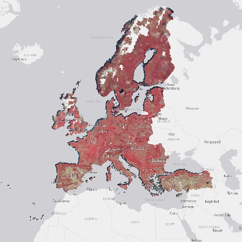
United Kingdom
Type of resources
Available actions
Topics
Keywords
Contact for the resource
Provided by
Years
Formats
Scale
Resolution
-
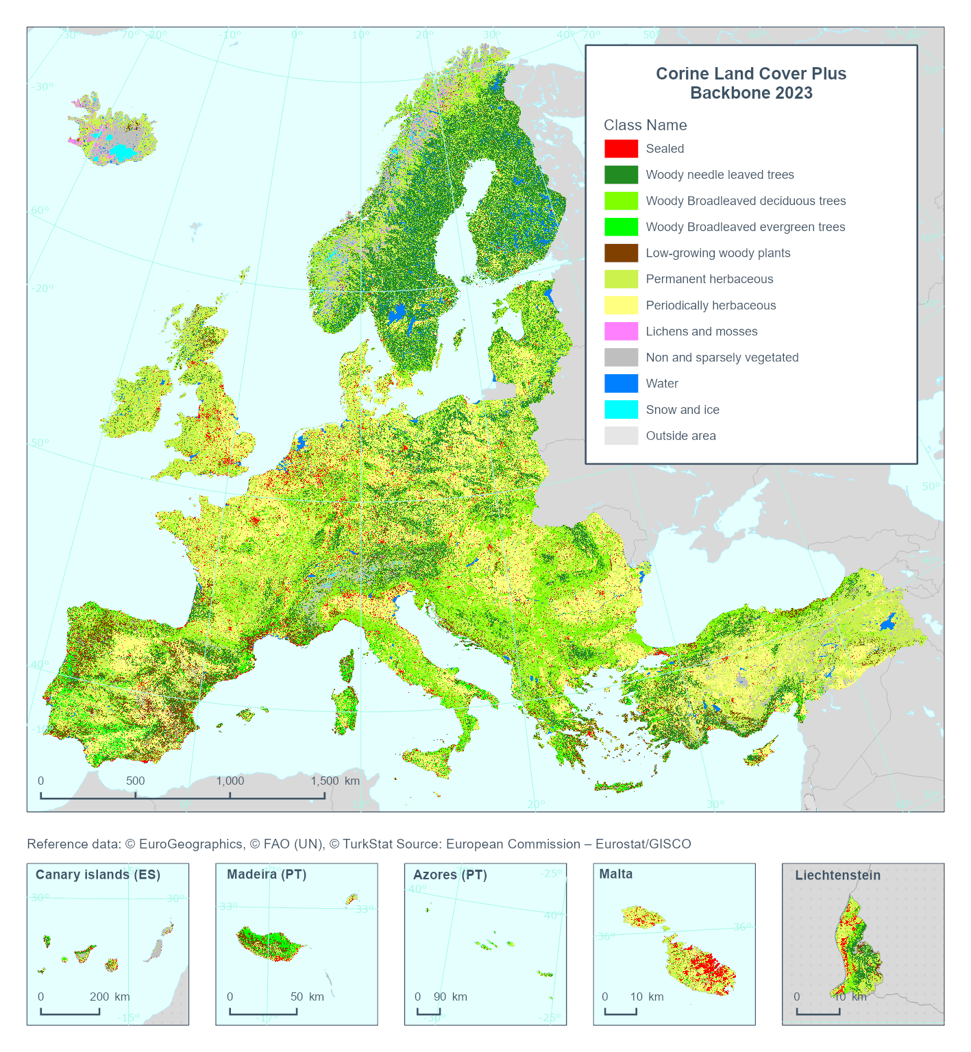
This metadata refers to the Corine Land Cover plus Backbone (CLCplus Backbone), a spatially detailed, large-scale, Earth Observation-based land cover inventory which is produced by the Copernicus Land Monitoring Service (CLMS). The CLCplus Backbone is a high-resolution raster land cover map based on Sentinel-2 satellite time series. Each 10m-pixel contains the dominant land cover among the 11 basic land cover classes. See pixel class codes in the 'Additional Information' section below. The product is available from the 2018 reference year, with a first update produced for the 2021 reference year and moved to an update cycle of 2 years from 2021 onwards.
-
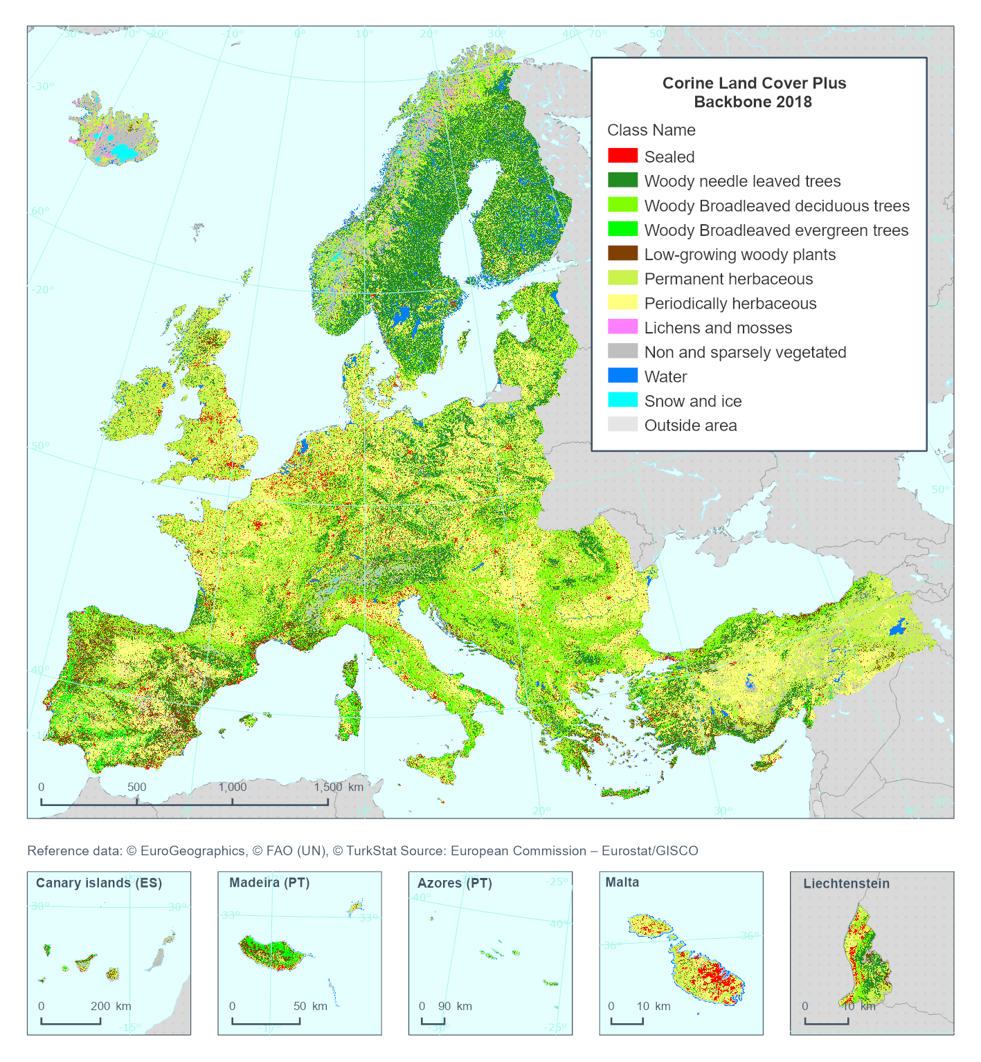
This metadata refer to the 'Corine Land Cover plus Backbone' (CLCplus Backbone) which is a spatially detailed, large scale, Earth Observation-based land cover inventory. The CLCplus Backbone Raster Product is a 10m pixel-based land cover map based on Sentinel satellite time series from July 2017 to June 2019. For each pixel it shows the dominant land cover among the 11 basic land cover classes. The product has a three years update cycle and is available for the 2018 reference year.
-
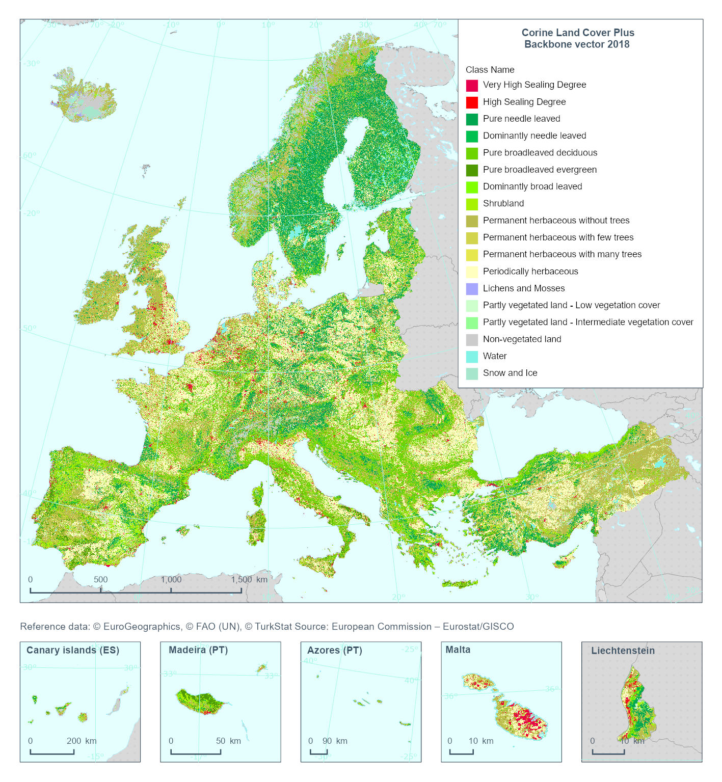
This metadata refers to the 'Corine Land Cover Plus Backbone' (CLCplus Backbone), a spatially detailed, large-scale, Earth Observation-based land cover inventory which is produced by the Copernicus Land Monitoring Service (CLMS). The CLCplus Backbone vector is a land cover map that contains vector polygon geometries (minimum mapping unit: 0.5 ha; minimum mapping width: 20 m) and is based on Sentinel satellite time series and a combination of existing reference datasets for geometries containing transportation and hydrological networks. Each polygon represents aggregated landscape objects and contains their dominant land cover among the 18 basic land cover classes. See polygon class codes in the additional information section. In addition, polygons are enriched with land cover fractions from the CLCplus Backbone raster as well as aggregated attributes based on other CLMS and Copernicus products (e.g. topography). CLCplus Backbone vector is an independent product and its thematic and geometric contents differ from CLCplus Backbone raster and Corine Land Cover. The CLCplus Backbone vector is available for the 2018 reference year. You can read more about the product here: https://land.copernicus.eu/en/products/clc-backbone
-

The Copernicus High Resolution Forest Layer Tree Cover Change Mask (TCCM) 2015-2018 raster product provides information on the change between the reference years 2015 and 2018 and consists of 4 thematic classes (unchanged areas with no tree cover / new tree cover / loss of tree cover / unchanged areas with tree cover) at 20m spatial resolution and covers EEA38 area and the United Kingdom. The production of the High Resolution Forest layers was coordinated by the European Environment Agency (EEA) in the frame of the EU Copernicus programme. The High Resolution Forest product consists of three types of (status) products and additional change products. The status products are available for the 2012, 2015 and 2018 reference years: 1. Tree cover density providing level of tree cover density in a range from 0-100%; 2. Dominant leaf type providing information on the dominant leaf type: broadleaved or coniferous; 3. A Forest type product. The forest type product allows to get as close as possible to the FAO forest definition. In its original (20m) resolution it consists of two products: 1) a dominant leaf type product that has a MMU of 0.5 ha, as well as a 10% tree cover density threshold applied, and 2) a support layer that maps, based on the dominant leaf type product, trees under agricultural use and in urban context (derived from CLC and high resolution imperviousness 2009 data). For the final 100m product trees under agricultural use and urban context from the support layer are removed.
-
The Copernicus High Resolution Water and Wetness (WAW) 2015 layer is a thematic product showing the occurrence of water and wet surfaces over the period from 2009 to 2015 for the EEA38 area and the United Kingdom. This metadata corresponds to the 20m classified Water and Wetness product. The production of the High Resolution Water and Wetness layers was coordinated by the European Environment Agency (EEA) in the frame of the EU Copernicus programme. Two WAW products are available: - The main Water and Wetness (WAW) product, with defined classes of (1) permanent water, (2) temporary water, (3) permanent wetness and (4) temporary wetness. - The additional expert product: Water and Wetness Probability Index (WWPI). The products show the occurrence of water and indicate the degree of wetness in a physical sense, assessed independently of the actual vegetation cover and are thus not limited to a specific land cover class and their relative frequencies. Data is provided as a mosaic of the full area, and as tiles with a side length of 1000 km x 1000 km. In 2020, and due to methodological improvements, the temporary wet class has been reprocessed during the update for the 2018 reference year. You can read more about the product here: https://land.copernicus.eu/en/products/high-resolution-layer-water-and-wetness/water-and-wetness-status-2015.
-

The Sentinel-2 Snow Phenology (SP S2) product is generated once a year at European scale, based on Fractional Snow Cover (FSC) products calculated from Sentinel-2 optical data. This product describes the snow season in terms of temporality as it provides, within an hydrological year and for each pixel, the number of days with snow cover, as well as the first and the last day of the longest observed snow period. It has a spatial resolution of 20 m x 20 m, as does the input FSC product. The SP S2 product is distributed in raster files covering an area of 110 km by 110 km with a pixel size of 20 m by 20 m in UTM/WGS84 projection, which corresponds to the Sentinel-2 input L1C product tile. Each product is composed of separate files corresponding to the different layers of the product, and another metadata file." The product is also available in another projection as tiles aligned with the Pan-European High-Resolution Layers in the European grid (ETRS89 LAEA - EPSG: 3035) at 20 m x 20 m and 100 m x 100 m. SP S2 is one of the products of the pan-European High-Resolution Water Snow & Ice portfolio (HR-WSI), which are provided at high spatial resolution from the Sentinel-2 and Sentinel-1 constellations data from September 1, 2016 onwards.
-

The Sentinel-1 and Sentinel-2 Snow Phenology (SP S1+S2) product is generated once a year over high-mountain areas at European scale, based on daily cumulative Gap-Filled Fractional Snow Cover (GFSC) products calculated from Sentinel-2 optical and Sentinel-1 radar data. This product describes the snow season in terms of temporality as it provides, for each pixel, the number of days with snow cover, as well as the first and the last day of the longest observed snow period. It has a spatial resolution of 100 m x 100 m. Each product is composed of separate files corresponding to the different layers of the product, and another metadata file. The product is also available in another projection as tiles aligned with Sentinel-2 (UTM/WGS84) at 60 m x 60 m. SP S1+S2 is one of the products of the pan-European High-Resolution Water Snow & Ice portfolio (HR-WSI), which are provided at high spatial resolution from the Sentinel-2 and Sentinel-1 constellations data from September 1, 2016 onwards. t.
-

This is the metadata covering the Sentinel-1 and Sentinel-2 Snow Phenology (SPS1S2) product. It is generated once a year over high-mountain areas at European scale, based on daily cumulative Gap-Filled Fractional Snow Cover (GFSC) products calculated from Sentinel-2 optical and Sentinel-1 radar data. This product describes the snow season in terms of temporality as it provides, for each pixel, the number of days with snow cover, as well as the first and the last day of the longest observed snow period. It has a spatial resolution of 60 m x 60 m, as does the input GFSC product. Each product is composed of separate files corresponding to the different layers of the product, and another metadata file." The product is also available in another projection as tiles aligned with the Pan-European High-Resolution Layers in the European grid (ETRS89 LAEA - EPSG: 3035) at 60 m x 60 m and 100 m x 100 m. SP S2+S2 is one of the products of the pan-European High-Resolution Water Snow & Ice portfolio (HR-WSI), which are provided at high spatial resolution from the Sentinel-2 and Sentinel-1 constellations data from September 1, 2016 onwards.
-

The High Resolution Layer (HRL) Grassland Change 2015-2018 raster product at 20m resolution provides information on changes in grassland vegetation cover between the reference years 2015 and 2018. The thematic classes indicate all non-grassland areas, grassland gain and grassland loss, unchanged grassland in both years and unverified grassland gain and loss areas for the pan-European area of EEA38 and the United Kingdom. The production of the High Resolution grassland layers was coordinated by the European Environment Agency (EEA) in the frame of the EU Copernicus programme. This dataset is provided as 20 meter rasters in 100 x 100 km tiles grouped according to the EEA38 countries and the United Kingdom (fully conformant with the EEA reference grid). The HRL Grassland layer is the main High Resolution grassland product. This grassy and non-woody vegetation baseline product includes all kinds of grasslands: managed grassland, semi-natural grassland and natural grassy vegetation. It is a binary status layer for the 2015 reference year mapping grassland and all non-grassland areas in 20m and (aggregated) 100m pixel size and, for the 2018 reference year, in 10m and (aggregated) 100m pixel size. You can read more about the product here: https://land.copernicus.eu/en/products/high-resolution-layer-grassland/grassland-change-2015-2018.
-
The pan-European High Resolution (HR) Image Mosaic 2006 provides HR2 (High Resolution: 20 meter) coverage over Europe. The surface covered by the image dataset is 5.8 million square kilometres and has a spatial resolution of 20 meters. The imagery is composed during specific acquisition windows between 2005 and 2007. Images are derived from the following satellite sensors: Resourcesat-1 SPOT-4/-5 The mosaic primarily is used as input data in the production of various Copernicus Land Monitoring Service (CLMS) datasets and services, such as land cover maps and high resolution layers on land cover characteristic and can be also useful for CLMS users for visualizations and classifications on land. The input imagery for the creation of the mosaic is provided by ESA. Due to license restrictions, HR Image Mosaic 2006 is only available as a web service (WMS), and not for data download.