 Arctic SDI catalogue
Oceanographic geographical features
Type of resources
Available actions
Topics
Keywords
Contact for the resource
Provided by
Years
Formats
Representation types
Update frequencies
status
Service types
Scale
Resolution
-
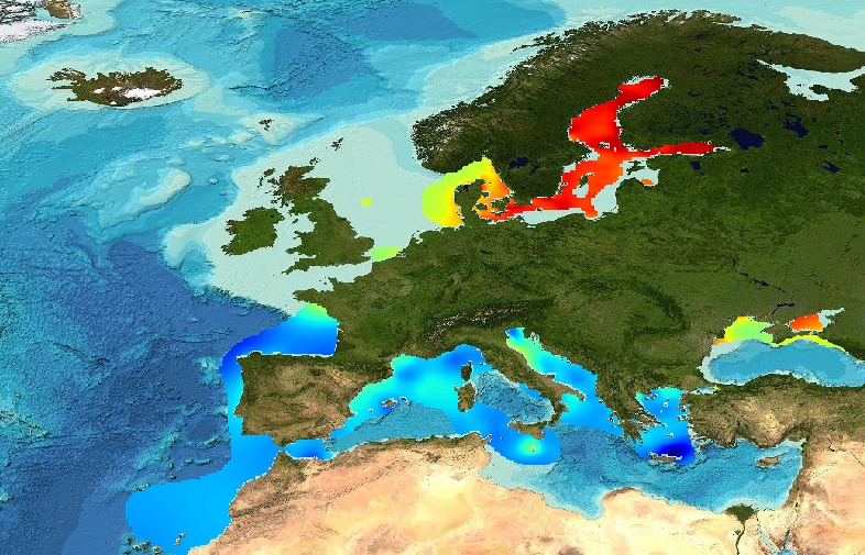
EMODnet Physics - TEMP_004 - Temperature monthly climatology for North Atlantic Ocean, Baltic Sea, Arctic Sea, Mediterranean Sea and Black Sea, covering the period from 1900 to 2014. This product is based on the SeaDataNet aggregated dataset v1.1.
-
Shapefile showing areas where ice concentration in the Barents Sea in 2018 was on average more than 20%. The 20% threshold was derived from WMO ice classification and corresponds to "Very open drift ice". Data averaged by Ifremer and NIVA derived from CMEMS (Copernicus) ice concentration product (resolution 1km, temporal resolution 1 year- 2018). Used in EUSeaMap 2019 as a proxy for the polar front affecting distribution of seabed habitats. Created by the EMODnet Seabed Habitats project consortium.
-
EMODnet Physics - Arctic Sea Ice Extend [2009 - ongoing] - Annual Max and Min contours. This product uses the Copernicus Marine Service product id. SEAICE_GLO_SEAICE_L4_NRT_OBSERVATIONS_011_001
-
The analysis was performed per season using DIVA software tool (Data-Interpolating Variational Analysis). The analyses products are stored as NetCDF CF files and made available as WMS layers for easy browsing and adding. Every step of the time dimension corresponds to a 6-year moving average from 1983 to 2016. The depth dimension spans from surface to 1000 m, with 21 vertical levels. The boundaries and overlapping zones between these regions were filtered to avoid any unrealistic spatial discontinuities. This combined water body dissolved oxygen concentration product is masked using the relative error threshold 0.5. Units: µmol/l Created by 'University of Liège, GeoHydrodynamics and Environment Research (ULiège-GHER)'. The data used as input for DIVA have been extracted from the EMODnet Chemistry Download Service: https://emodnet-chemistry.maris.nl/search Intermediate regional data products: Mediterranean Sea - DIVA 4D 6-year analysis of Water body dissolved oxygen concentration 1971/2017 v2018, Arctic Ocean - DIVA 4D 6-year analysis of Water body dissolved oxygen concentration 1980/2017 v2018, North Sea - DIVA 4D 6-year analysis of Water body dissolved oxygen concentration 1980/2017 v2018, Black Sea - DIVA 4D 6-year analysis of Water body dissolved oxygen concentration 1990/2016 v2018, North East Atlantic Ocean - DIVA 4D 6-year analysis of Water body dissolved oxygen concentration 1960/2017 v2018, Baltic Sea - DIVA 4D 6-year analysis of Water body dissolved_oxygen_concentration 1980/2016 v2018
-
This layer was created for the EUSeaMap 2019. It was computed from the CMEMS product "ARCTIC OCEAN - SEA ICE CONCENTRATION CHARTS - SVALBARD" (product identifier: SEAICE_ARC_SEAICE_L4_NRT_OBSERVATIONS_011_002). Daily values were averaged over the year 2018
-

Moving 6-year analysis of phosphate in the Arctic Ocean, for each season in the period 1965-2024. Every year of the time dimension corresponds to the 6-year centered average for each season. Winter: December-February, Spring: March-May, Summer: June-August, Autumn: September-November. Depth range (IODE standard depths): 0, 5, 10, 20, 30, 40, 50, 75, 100, 125, 150, 200, 250, 300, 400, ..., 1500, 1750, 2000, 2500m. Units: umol/l. Description of DIVA analysis: The computation was done with DIVAnd (Data-Interpolating Variational Analysis in n dimensions), version 2.7.13, using GEBCO 30sec topography for the spatial connectivity of water masses. The horizontal resolution of the produced DIVAnd maps grids is 0.125 degrees. Signal-to-noise ratio was fixed to 3.0, horizontal correlation length varying from 45 km near the coast to 150 km, and vertical correlation length varying between 25 and 1000 m. Logarithmic transformation is applied to the data prior to the analysis. Background field: analysis with signal-to-noise ratio = 20, horizontal correlation length 50-200 km, and vertical correlation length 25-1000 m.
-
In the Northwest Atlantic, Pandalus borealis (northern shrimp) serve as key mid-trophic consumers and prey for higher-trophic predators, including commercially important fish species. However, the impact of changing environmental conditions on trophic interactions and lipid storage in sub-Arctic ecosystems is not well understood. We employed biochemical tracers (fatty acids and stable isotopes) to investigate the trophic ecology and stage-specific nutritional condition of P. borealis across spatial and seasonal scales. A total of 68 different fatty acids (FAs) were identified in P. borealis tissues (i.e., muscle and eggs). The relative abundances of these FAs varied among sex, tissues, seasons, and fishing areas. Results revealed that P. borealis primarily fed on diatoms and zooplankton, with opportunistic feeding on sinking phytodetritus. Lipid composition showed strong seasonality, with storage triacylglycerols being the predominant lipid class. Ovigerous females exhibited the highest lipid concentrations and essential fatty acids, emphasizing the ecological importance of eggs as high-quality lipid sources. Additionally, total lipid content in eggs increased from spring to summer, highlighting vulnerability to shifts in seasonal primary production. This study underscores the significant seasonal variability in the nutritional status of P. borealis and the need to understand lipid dynamics to assess population resilience to environmental changes. Important Note: This submission has been initially submitted to SEA scieNtific Open data Edition (SEANOE) publication service and received the recorded DOI. The metadata elements have been further processed (refined) in EMODnet Ingestion Service in order to conform with the Data Submission Service specifications.
-
This dataset is associated with the publication by Nicole Couto, Jennifer MacKinnon, Harper Simmons, and Matthew Alford, "Near-bottom baroclinic and submesoscale instability at the Chukchi shelfbreak." Four FastCTD sections and one Modular Microstructure Profiler (MMP) were collected crossing the Chukchi shelf break in September 2018 from the R/V Sikuliaq. Current velocities were measured simultaneously from two hull-mounted ADCPS: an RDI Workhorse 300 kHz and an RDI Ocean Surveyor 75 kHz. Important Note: This submission has been initially submitted to SEA scieNtific Open data Edition (SEANOE) publication service and received the recorded DOI. The metadata elements have been further processed (refined) in EMODnet Ingestion Service in order to conform with the Data Submission Service specifications.
-

Running 6-year analysis of Water body phosphate in the Baltic Sea. Four seasons (March-May, June-August, September-November, December-February). Every year of the time dimension corresponds to a 6-year centred average. Periods span between 1955-2023. Analyses for depths (m) (HELCOM standard depths): 0, 5, 10, 15, 20, 30, 40, 50, 60, 70, 80, 90, 100, 125, 150, 175, 200, 225, 250, 275, 300. Data Sources: observational data from SeaDataNet/EMODnet Chemistry Data Network. Description of DIVA analysis: Geostatistical data analysis by DIVAnd (Data-Interpolating Variational Analysis in n dimensions) tool. GEBCO_08 Grid (30 arc-seconds) topography is used for the contouring preparation. Files contain analysed fields, error fields and combined field with the deepest value for each grid point selected. Also pre-masked fields using relative error threshold 0.3 and 0.5 are included. In the analyses the horizontal correlation length is fixed to 80 km and decreasing towards the coastline, the vertical correlation length is varying with depth. Signal to noise ratio is fixed to 1.0. Background fields were created using data for the given time period and season. Log transformation was used in the analyses. No detrending, advection constraints or weighting are applied. Unit is umol/l.
-

Running 6-year analysis of Water body dissolved inorganic nitrogen in the Baltic Sea. Four seasons (March-May, June-August, September-November, December-February). Every year of the time dimension corresponds to a 6-year centred average. Periods span between 1975-2023. Analyses for depths (m) (HELCOM standard depths): 0, 5, 10, 15, 20, 30, 40, 50, 60, 70, 80, 90, 100, 125, 150, 175, 200, 225, 250, 275, 300. Data Sources: observational data from SeaDataNet/EMODnet Chemistry Data Network. Description of DIVA analysis: Geostatistical data analysis by DIVAnd (Data-Interpolating Variational Analysis in n dimensions) tool. GEBCO_08 Grid (30 arc-seconds) topography is used for the contouring preparation. Files contain analysed fields, error fields and combined field with the deepest value for each grid point selected. Also pre-masked fields using relative error threshold 0.3 and 0.5 are included. In the analyses the horizontal correlation length is fixed to 80 km and decreasing towards the coastline, the vertical correlation length is varying with depth. Signal to noise ratio is fixed to 1.0. Background fields were created using data for the given time period and season. Log transformation was used in the analyses. No detrending, advection constraints or weighting are applied. Unit is umol/l.