 Arctic SDI catalogue
river
Type of resources
Available actions
Topics
Keywords
Contact for the resource
Provided by
Years
Formats
Representation types
Update frequencies
status
Service types
Scale
Resolution
-
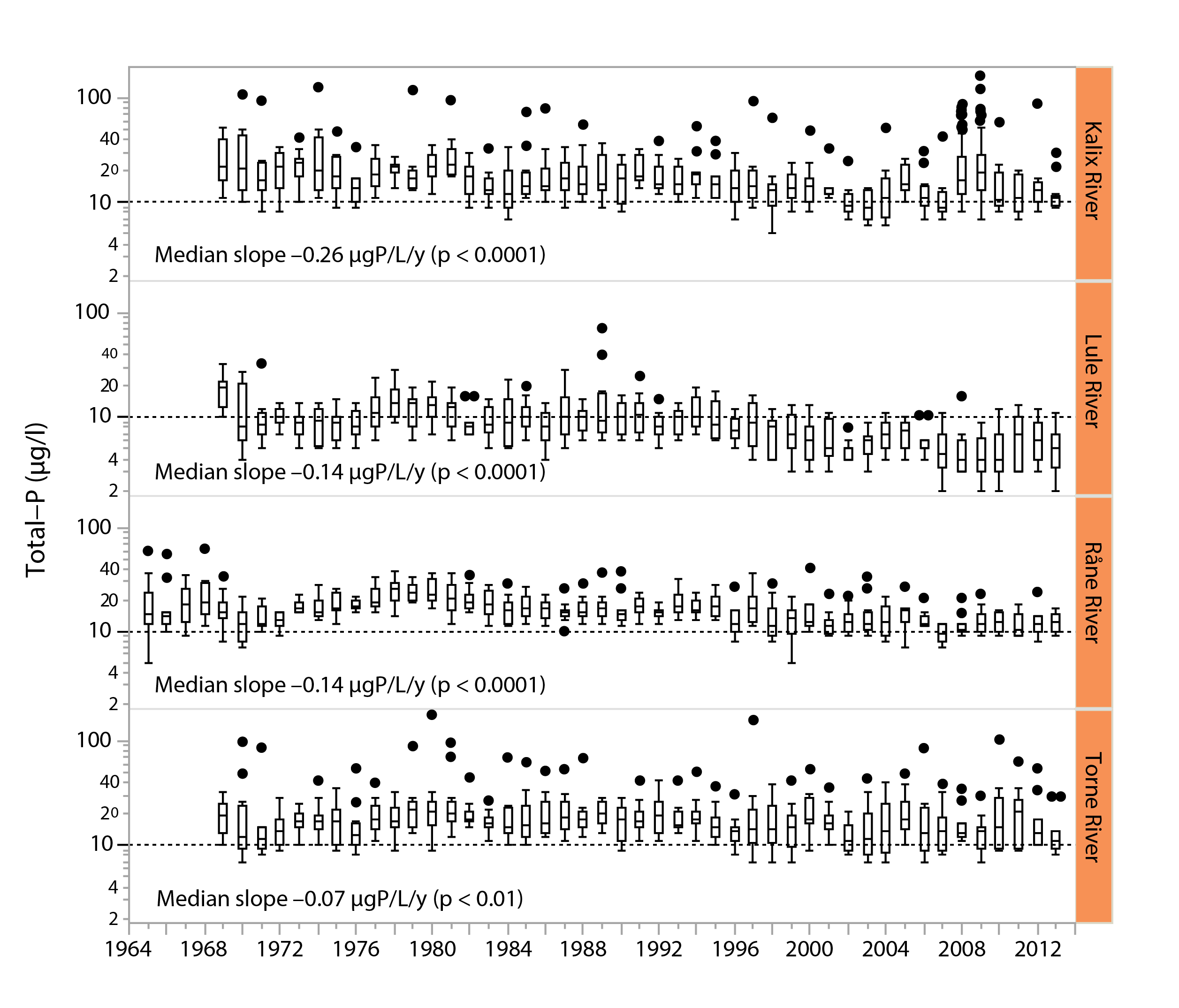
Figure 3-3 Long-term trends in total phosphorus water concentrations (μg/L) in four major, unregulated rivers that drain the subarctic Arctic/alpine ecoregion of the Scandinavian peninsula, the Kalix river, The Lule river, the Råne river, and the Torne river. Slopes and p-values are given in the different panels. Boxes indicate medians and 25th and 75th percentiles, while whiskers give the 10th and 90th percentiles. State of the Arctic Freshwater Biodiversity Report - Chapter 3 - Page 21 - Figure 3-3
-
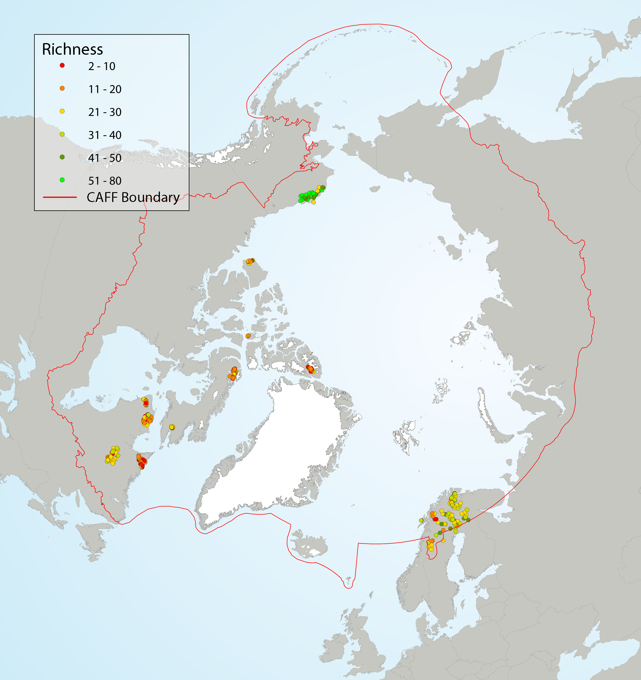
Local diatom species richness of Arctic diatom assemblages from stream scrapes, showing (left) richness as a function of latitude, and (right) site-specific richness. A LOESS smoother (blue line) with a span of 0.75 and a 95% confidence interval (grey shading) was applied to the data (left) to better highlight the general trend. Coloured circles on the map indicate species richness at the sampling sites. State of the Arctic Freshwater Biodiversity Report - Chapter 4 - Page 37 - Figure 4-10
-

Rivers of the city of Trois-Rivières**This third party metadata element was translated using an automated translation tool (Amazon Translate).**
-

List of freshwater fish species recorded from survey data throughout Nova Scotia.
-
Wetlands in the City of Trois-Rivières**This third party metadata element was translated using an automated translation tool (Amazon Translate).**
-
Natural areas of interest in the City of Trois-Rivières**This third party metadata element was translated using an automated translation tool (Amazon Translate).**
-

Surface drainage features including rivers, streams, lakes, islands, and watershed boundaries including names for many rivers and streams. Individual components of this dataset can be found on DNRED’s Open Data Catalogue. Those individual components may be more up-to-date than those used in this packaged dataset.
-

The Canadian Heritage Rivers System (CHRS) is Canada's national river conservation program. Established in 1984, the CHRS gives national recognition to Canada's outstanding rivers and encourages their long term management to conserve their natural, cultural and recreational values for the benefit and enjoyment of Canadians, now and in the future. There are currently 42 Canadian Heritage Rivers, 4 are in the Yukon. For more information about CHRS refer to [https://chrs.ca/en](https://chrs.ca/en) Distributed from [GeoYukon](https://yukon.ca/geoyukon) by the [Government of Yukon](https://yukon.ca/maps) . Discover more digital map data and interactive maps from Yukon's digital map data collection. For more information: [geomatics.help@yukon.ca](mailto:geomatics.help@yukon.ca)
-
Atlas of Canada National Frameworks data are standardized national coverages of commonly used geospatial datasets at the 1:1 000 000 scale. The Drainage Network Skeleton dataset is comprised of linear features: single line rivers, flow lines within waterbodies and ocean coastlines. Flow lines within waterbodies are virtual linear features representing the hydrological flow through area features (e.g. lakes, rivers and intermittent waterbodies). These flow lines complete the linear network where rivers would run through lakes, permitting hydrologic network analysis and cartographic generalization. This dataset is required for analytical applications. The coastline component of the Drainage Network Skeleton also delineates oceanic islands. The National Scale Frameworks Hydrology data consists of area, linear and point geospatial and attribute data for Canada's hydrology at a national scale. It provides a representation of Canada's surface water features, and data completeness reflects the content of the source, the original Vector Map level 0 (VMAP0) revision 4 hydrographic layers, except where revision editing has been performed. Key value-added characteristics include river flow direction, connectivity and the tagging of geographical name keys to selected rivers, lakes and islands included in the Concise Gazetteer of Canada. The Atlas Frameworks are a set of integrated base map layers which form part of a larger National Scale Frameworks data collection. These data have been compiled at a scale of 1:1 000 000 with the primary goal being to indicate correct relative positioning with other framework layers rather than absolute positional accuracy. Distributed from [GeoYukon](https://yukon.ca/geoyukon) by the [Government of Yukon](https://yukon.ca/maps) . Discover more digital map data and interactive maps from Yukon's digital map data collection. For more information: [geomatics.help@yukon.ca](mailto:geomatics.help@yukon.ca)
-

The aquatic ecosystem classification (AEC) is a science-based tool that groups and classifies Ontario’s rivers and streams based on their: * physical attributes, such as water temperature * watershed characteristics, such as upstream drainage area The Ministry of Natural Resources and Forestry (MNRF) is responsible for sustainably managing and deriving economic benefit from the fisheries and water resources in the 490,000 km of Ontario’s rivers and streams. The AEC reduces the complexity of these vast aquatic networks using consistent and quantitative methods to build a standardized data foundation that helps MNRF staff with landscape level planning and policy development.