 Arctic SDI catalogue
Land management
Type of resources
Available actions
Topics
Keywords
Contact for the resource
Provided by
Years
Formats
Representation types
Update frequencies
status
Service types
-
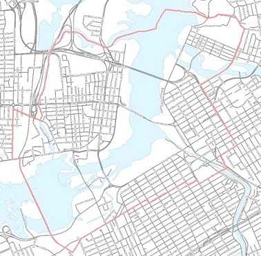
Delimited area of the Core Area Sector Plan as of 2005. https://ncc-ccn.gc.ca/our-plans/canadas-capital-core-area-sector-plan https://ncc-website-2.s3.amazonaws.com/documents/01.pdf
-

The Social Vulnerability component of the National Human Settlement Layer (NHSL) includes information about broad spatial patterns of social vulnerability at the neighbourhood scale, and indicators about the capacities for a community to withstand and recover from disaster events based on intrinsic characteristics of housing, family structure, individual autonomy and financial agency. Information in the model provides a means of comparing relative levels of social vulnerability from one region to another across Canada and helps to identify specific dimensions within a community that contributes to their relative levels of social vulnerability. This information is not intended for site-specific study, but instead to understand broad patterns of social characteristics and vulnerability across multiple census dissemination areas.
-

The Physical Exposure component of the National Human Settlement Layer (NHSL), defined here as the ‘Physical Exposure Model’, includes a delineation of settled areas and related land use across Canada, as well as information about buildings, persons, and building replacement values (structure and contents) within those areas. Buildings within the inventory are classified using a combination of occupancy types, engineering-based construction types adopted for Canada, and design levels representing the approximate building code requirements at the time of construction. The inventory is derived from detailed housing statistics provided at the dissemination area level as part of the 2016 national census and from georeferenced business listings. Building populations at different times of day are estimated for standard daytime hours (9am-5pm); for morning and evening commute hours (7am-9am; 5pm-7pm), and; for nighttime hours when the majority of people are home (7pm-7am). Replacement values are provided for structural, nonstructural, and contents components of buildings, based on industry replacement costs for representative regions across Canada. The physical exposure model is provided in two formats: (1) According to settled areas (i.e., polygons), which are areas that approximately delineate clusters of buildings across Canada. Summary statistics about buildings and populations within each settled area boundary are provided. (2) According to building archetypes (i.e., points) within settled areas. These are represented as point locations at the centroid of the corresponding settled area, and each settled area can have multiple point features corresponding to different building archetypes present within that area. In total, the model characterizes 35.2 million people in 9.7 million buildings across 390,000 locations with a total approximate replacement value of $8.2 trillion (2019 CAD) including contents.
-

The “Agricultural Major Land Practices Groups of the Canadian Prairies” dataset lays out the areas of the 5 Major Land Practices Groups of the agricultural portions of the Canadian Prairies. They are represented by vector polygons amalgamated (dissolved) from the Version 1.9 SLC polygons sharing common water resources, land use and farming practices as developed in the “Agricultural Land Practices Groups of the Canadian Prairies by SLC Polygon” of this series. The dataset is based upon selected attributes from the Soil Landscapes of Canada (SLC) and the 1996 Census of Agriculture. Typical attributes including: land in pasture, land in summerfallow, crop mixture, farm size and the level of chemical and fertilizer inputs.
-

This land cover data set was derived from the Advanced Very High Resolution Radiometer (AVHRR) sensor operating on board the United States National Oceanic and Atmospheric Administration (NOAA) satellites. Information on the NOAA series of satellites can be found at www.noaa.gov/satellites.html The vegetation and land cover information set has been classified into twelve categories. Information on the classification of the vegetation and land cover, raster to vector conversion, generalization for cartographic presentations is included in the paper "The Canada Vegetation and Land Cover: A Raster and Vector Data Set for GIS Applications - Uses in Agriculture" (https://geogratis.cgdi.gc.ca/download/landcover/scale/gis95ppr.pdf). A soil quality evaluation was obtained by cross-referencing the AVHRR information with Census of Agriculture records and biophysical (Soil Landscapes of Canada) data and is also included in the above paper. AVHRR Land Cover Data approximates a 1:2M scale and was done originally for Agriculture Canada. The projection used is Lambert Conformal Conic (LCC) 49/77 with origin at 49N 95W.
-
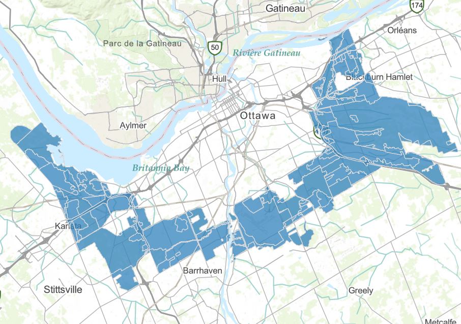
In the Greenbelt Master Plan (2013), the proposed land designations are a “classification” which assigns desired landscape character and uses to defined land areas across the Greenbelt. Areas are classified according to their desired role, whether to protect biodiversity, maintain agricultural resources, or accommodate permanent facilities. https://ncc-ccn.gc.ca/our-plans/greenbelt-master-plan https://ncc-website-2.s3.amazonaws.com/documents/final-2013-greenbelt-master-plan-en.pdf#page=69
-
This dataset is aligned to a grid that with a dataset of soil attributes following GlobalSoilMap standards and specifications at specified depth increments extending over the agricultural portion of Canada. The SLC map polygons were rasterized and combined with the Shuttle Radar Topography Mission (SRTM) 90 metre grid to create the gridded raster dataset. Weighted averages of soil attribute properties are generated from existing soil horizon information to conform to recognized fixed depth increments. Soil attribute weighted means are calculated by using all the soil components based on their areal extent in each SLC polygon. The polygonal attribute weighted mean averages are spatially represented by the grid. For more information, visit: http://open.canada.ca/data/en/dataset/cb29b370-3639-4645-9ef9-b1ef131837b7
-
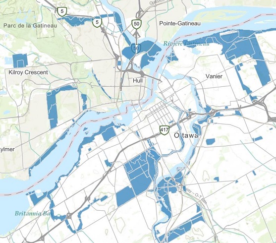
In the Capital Urban Lands Plan (2015), Land designations identify the desired uses for federal urban lands in relation to the role they play for the Capital in a given location. Each land designation provides policy direction for an ensemble of sites that serve similar functions. https://ncc-ccn.gc.ca/our-plans/capital-urban-lands-plan https://ncc-website-2.s3.amazonaws.com/documents/Capital-Urban-Lands-plan.pdf#page=45
-
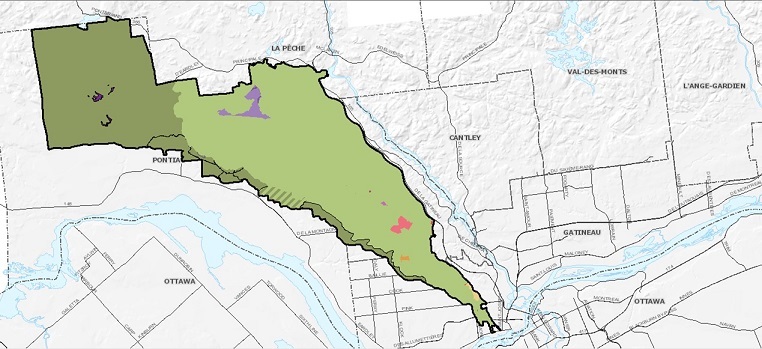
Described in the Gatineau Park Master plan (2021), the land use designations are the authorized activities or uses in a given area. They support the implementation of the park’s vision and goals. They also ensure that interventions and activities are spatially and functionally consistent. https://ncc-ccn.gc.ca/our-plans/gatineau-park-master-plan https://ncc-website-2.s3.amazonaws.com/documents/GPMP_ENG_2021_02_26_Single_Page.pdf#page=65
-
The National Human Settlement Layer (NHSL) is a collection of thematic datasets that describe the physical, social and economic characteristics of urban centres and rural/remote communities across Canada, and their vulnerability to natural hazards of concern. Detailed information on land use, buildings, people and capital assets are provided at the Census Dissemination Area administrative level for more than 454,000 settled areas across Canada. The Physical Exposure Layer includes a delineation of human settlement areas and related functional land use classes across Canada, and provides detailed information on construction type, occupancy and design level of more than 9.1 million buildings; population dynamics at different times of day for 35.1 million people, and; capital asset valuation of buildings and contents totaling more than 8.3 trillion CAD$. The Social Fabric Layer utilizes Census demographic data to evaluate broad spatial patterns of vulnerability, and neighbourhood-level capacities to withstand and recover from disaster events based on intrinsic characteristics of housing, family structure, individual autonomy and financial agency. Although developed to support quantitative risk assessments and implementation of the Sendai Framework for Disaster Risk Reduction at local and regional scales in Canada, the NHSL is also suitable for use in other integrated landscape modeling applications, including climate change adaptation and sustainable land use planning.