 Arctic SDI catalogue
Sedimentary rocks and processes
Type of resources
Available actions
Topics
Keywords
Contact for the resource
Provided by
Formats
Representation types
Update frequencies
status
Scale
-
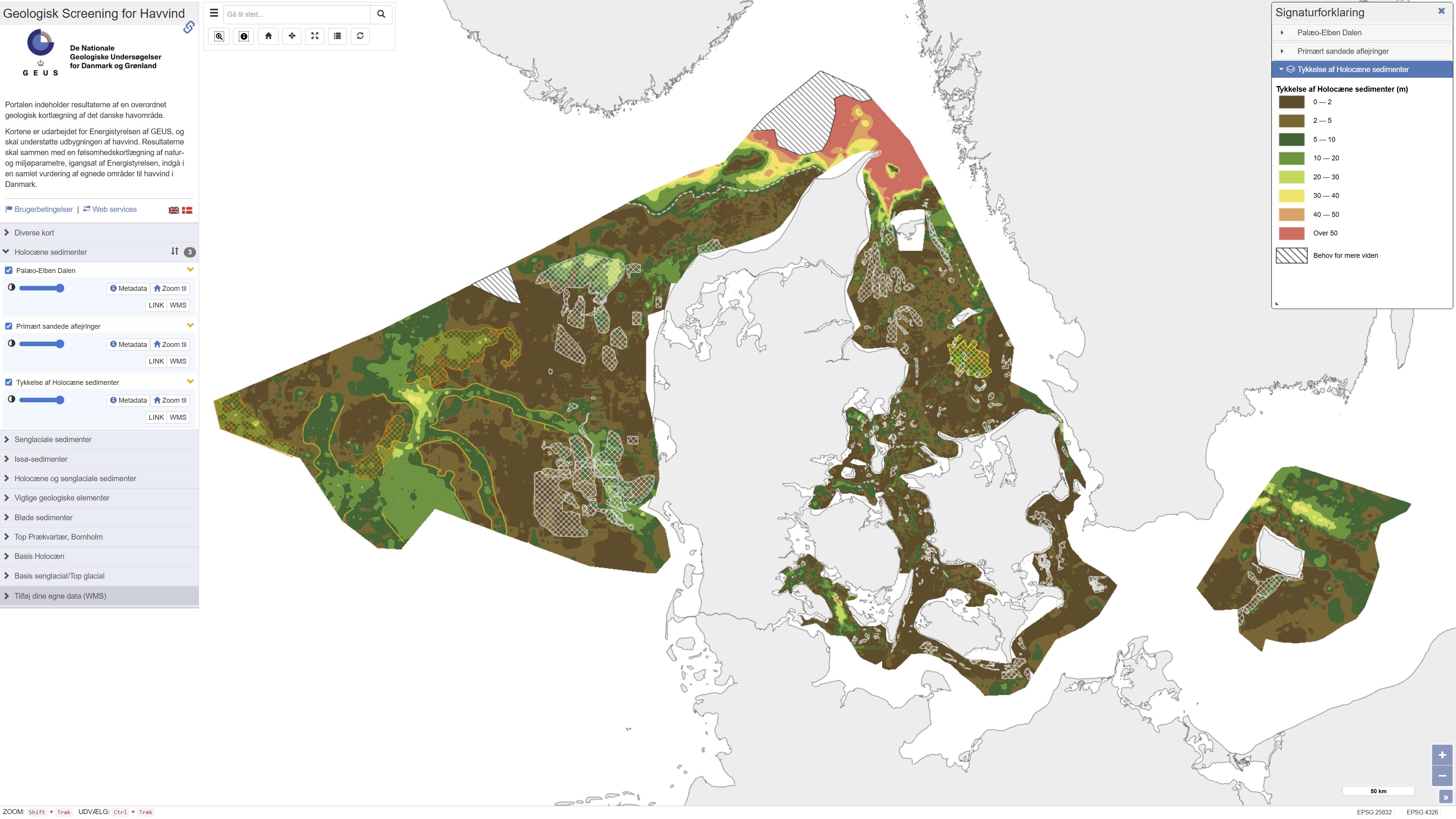
This repository contains maps of the thickness of late glacial and Holocene deposits in the Danish sea area, prepared as a basis for planning offshore wind. These are unconsolidated sediments that have not been overrun by the ice sheets of the ice ages, and therefore may have low geotechnical strength parameters. This is a large-scale and very general mapping, and no detailed interpretation of the distribution of sand and clay/mud/silt, respectively, has been made. In relation to the foundations of offshore wind turbines, sandy deposits will typically not pose a challenge, while soft deposits of clay, mud and silt in large thicknesses are assumed to pose foundation challenges. In addition to separate maps of the thickness of late glacial and Holocene deposits, a map of the total thickness of these two units has also been prepared, which thus constitutes a map of the total thickness of potentially soft sediments. Finally, the thickness of potentially soft sediments is used to divide the Danish sea area into categories in relation to the probability of larger thicknesses of soft sediments that could give rise to foundation challenges. Other maps are the thickness of potentially soft glacial lake sediments in the North Sea, the depth to the Pre-Quaternary surface in the waters around Bornholm, as well as the depth to the base of the Holocene deposits and the depth to the base of the late glacial deposits/top of the glacial deposits in the Danish sea area. As a supplement to the maps, a number of themes show where the late glacial and Holocene deposits are primarily expected to consist of sandy sediments. In addition, a number of themes show the Danish exclusive economic zone (EEZ), the location of conceptual geological models that can be seen in the overall report, all interpreted seismic lines, areas with near-surface gas in the sediments, interpreted distribution of the Palaeo-Elbe Valley in the North Sea, distribution of the Weichsel ice and ice-affected sediments in the North Sea, buried valleys (Prins & Andresen 2019; van der Vegt et al. 2012; Ottesen et al. 2020; Kirkham et al. 2024; Sandersen & Jørgensen 2016), structural elements (Al Hseinat & Hübscher 2017; Jensen et al. 2002), ice margin lines (Lange 1984; Kjær et al. 2003; Pedersen 2005; Phillips et al. 2018, 2022; Kirkham et al. 2024; Szuman et al. 2024; Pedersen & Boldreel 2017). The data basis for the work has primarily been new and existing near-surface seismic data and vibrocore drilling. The mapping was carried out for the Danish Energy Agency by GEUS, and is intended to support the development of offshore wind. The results, together with a sensitivity mapping of natural and environmental parameters, initiated by the Danish Energy Agency, are to be included in an overall assessment of suitable areas for offshore wind in Denmark.
-
The dataset comprises geochemical analyses of 1,269 soil samples collected in Greenland from 1974 onwards as part of systematic geochemical mapping and mineral exploration programmes. Soil samples were primarily collected in areas lacking developed stream channels where stream sediment sampling was not feasible. The samples represent surface material and have been analysed for major and trace elements using various laboratory methods including X-ray Fluorescence Spectrometry (XRF), Instrumental Neutron Activation Analysis (INA), Inductively Coupled Plasma Emission Spectrometry (ICP), and Atomic Absorption Spectrometry (AAS). The dataset contains the original analytical results as received from the laboratories together with administrative information on sample location and analysed grain-size fraction. The data form part of the analytical basis for the Geochemical Atlas of West and South Greenland.
-
The dataset comprises digital element distribution maps based on geochemical analyses of stream sediments collected in West and South Greenland. The maps were produced as part of the geochemical mapping programme underlying the Geochemical Atlas of West and South Greenland. The data represent analyses of various elements in defined grain-size fractions and provide a regional overview of geochemical variations.
-
The dataset contains geochemical analyses of 49 scree (talus) samples collected in Greenland as part of regional geochemical mapping programmes conducted by the Geological Survey of Greenland (GGU), later GEUS, between 1977 and 1997. Scree samples were collected in areas where neither stream sediment nor soil sampling was feasible. The samples represent near-surface material derived from local bedrock and were analysed for major and trace elements using laboratory methods available at the time of collection. The dataset supplements regional geochemical data from stream sediment and soil samples and forms part of the overall basis for geochemical mapping in Greenland.
-
This dataset comprises regional geochemical stream sediment data from West and South Greenland and forms the basis of the Geochemical Atlas of West and South Greenland (Steenfelt, 2001). The Geochemical Atlas of West and South Greenland presents the results of a regional stream sediment geochemical mapping programme conducted between 1979 and 1998. A total of 7,122 stream sediment samples were collected from low-order streams with near-uniform spatial coverage across West and South Greenland. The <0.1 mm grain-size fraction of 500 g samples was analysed for major and trace elements using X-ray fluorescence spectrometry (XRF), instrumental neutron activation analysis (INAA), delayed neutron counting (DNC) and loss on ignition (LOI). After systematic calibration and quality control to eliminate analytical bias between different methods and time periods, a harmonised and internally consistent dataset was established containing up to 43 elements per sample. The atlas provides a regional overview of the geochemical composition of the minerogenic fraction of stream sediments and constitutes a geochemical baseline dataset for geological mapping and mineral exploration in Greenland.
-
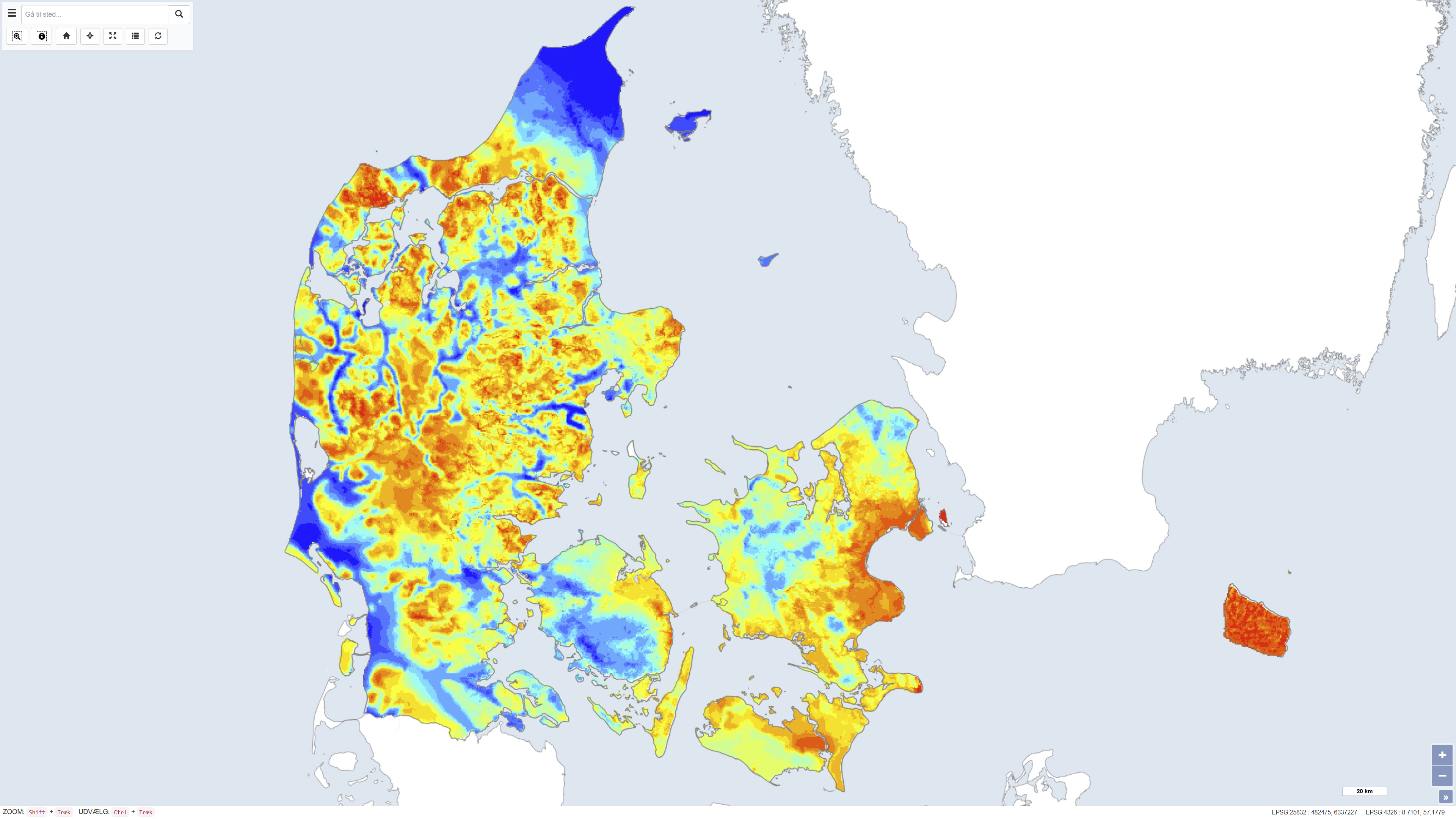
The dataset shows the thickness of Quaternary deposits in Denmark. The thickness has been calculated as the difference between surface elevation and the depth to the top of the pre-Quaternary deposits. The map provides a nationwide overview of variations in Quaternary thickness and is used in geological, hydrogeological and planning-related contexts.
-
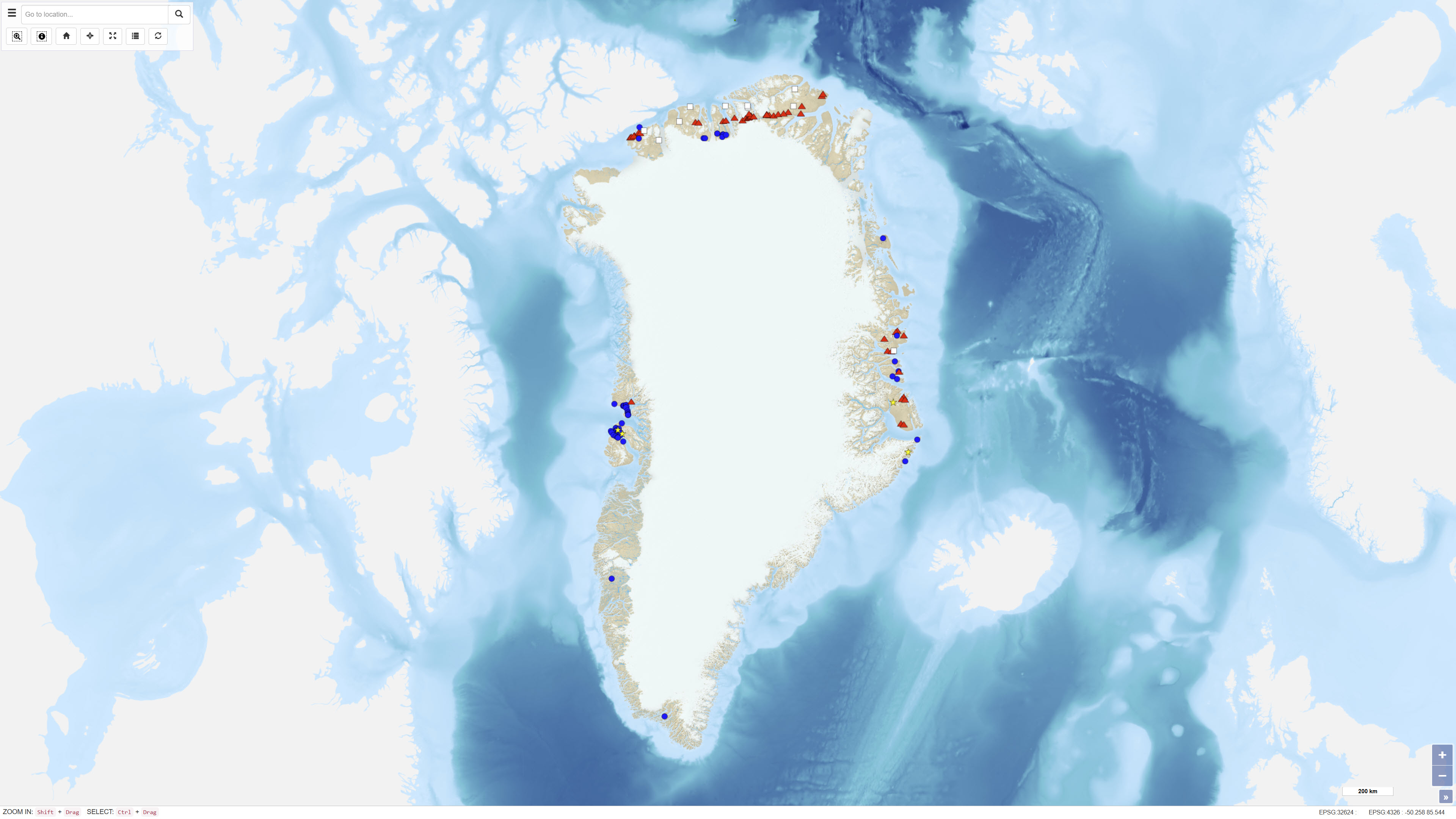
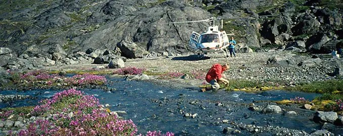
The dataset comprises a systematic inventory of onshore petroleum seeps and stains in Greenland. The inventory includes information on approximately 130 localities distributed across Palaeozoic, Mesozoic and Cenozoic sedimentary basins in Greenland. For each locality, coordinates, site descriptions, classification of seep type, geological context, sample numbers and references to reports and publications are recorded. The classification includes oil seeps, gas seeps, mud diapirs and gas-rich springs, oil stains in volcanics, carbonates and sandstones, solid macroscopic bitumen, and fluid inclusions and other evidence of micro-seepage. The dataset synthesises existing knowledge of petroleum systems in Greenland and provides a comprehensive overview of documented natural hydrocarbon occurrences onshore.
-
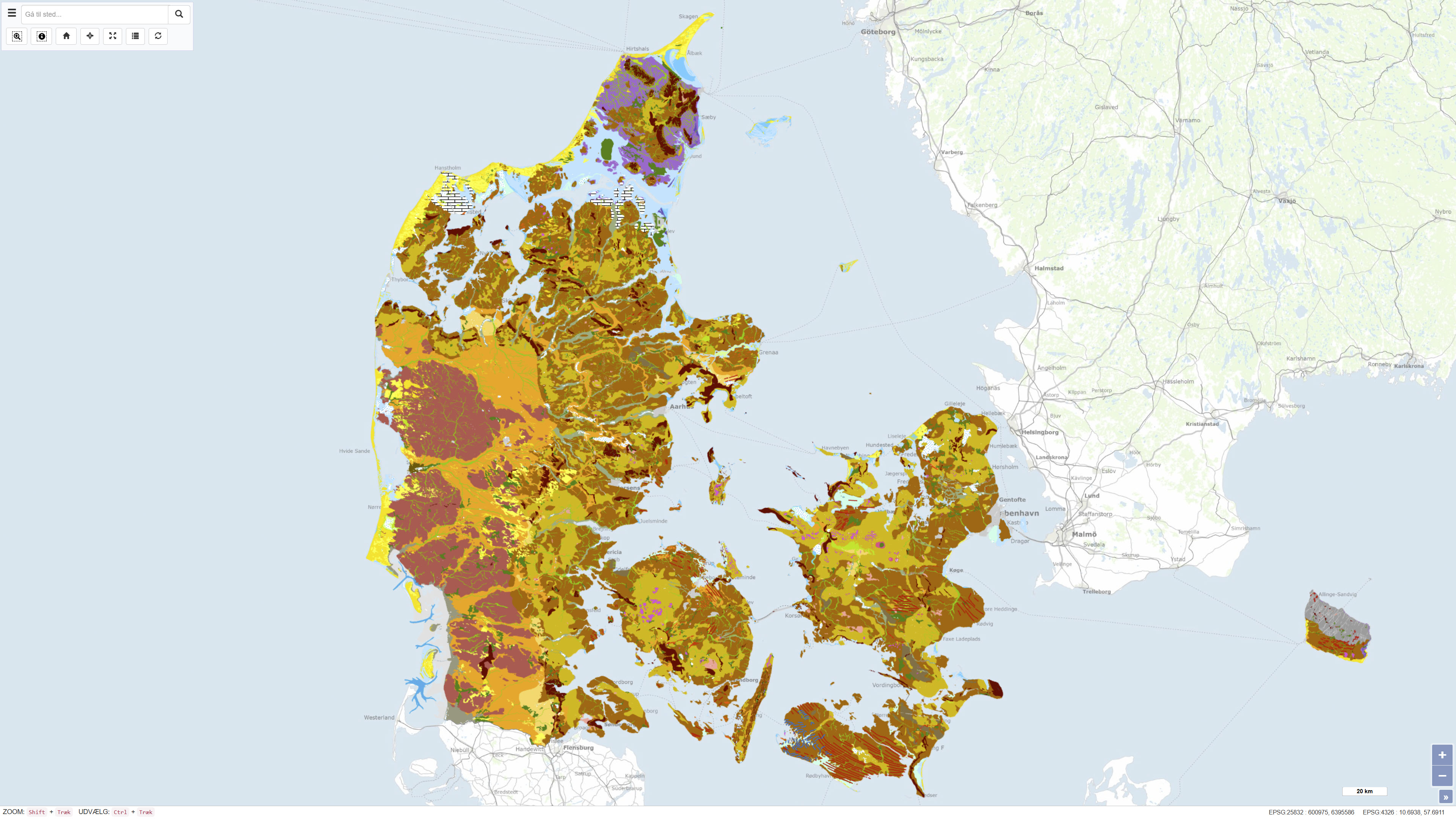
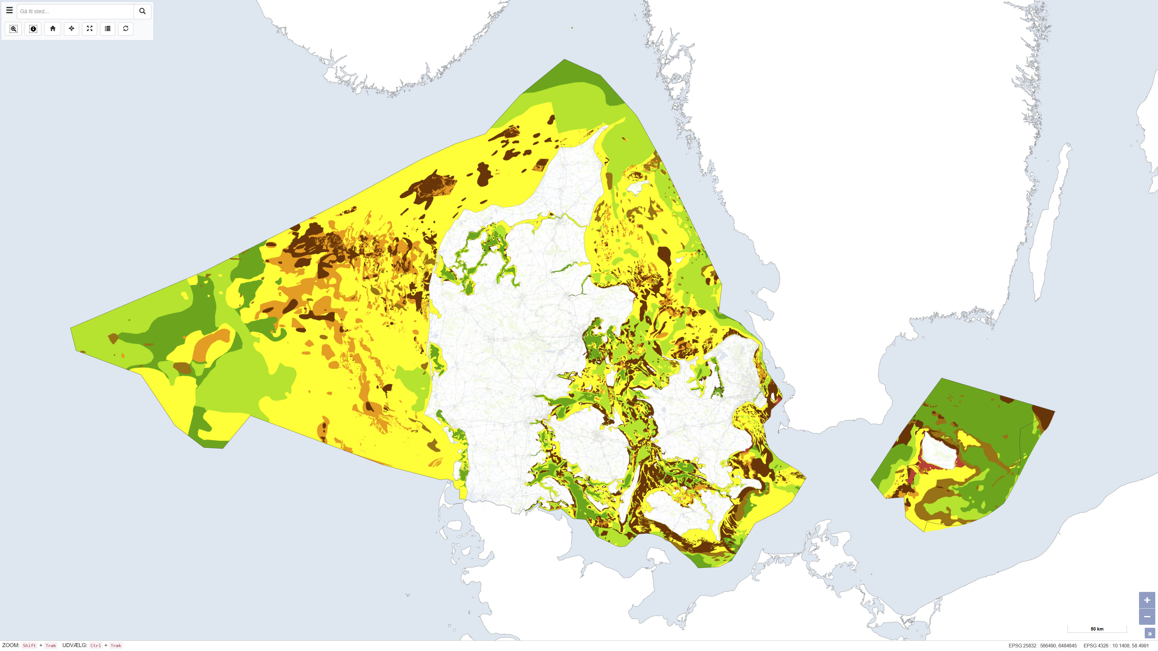
The Geomorphological Map of Denmark, version 3 (2022), depicts landscape types across Denmark at a scale of 1:200.000. The landscape types are defined based on shared geomorphological characteristics that can be related to the processes responsible for their formation. Most landscape types were formed during Quaternary glaciations and by meltwater from the glaciers, while the map also includes post-glacial landscapes such as marine and coastal environments, river valleys, lakes and wetlands, as well as aeolian landforms. The map further reflects landscape features influenced by pre-Quaternary bedrock, including exposed crystalline basement on Bornholm and chalk formations in northern Jutland, as well as surface features related to subsurface structural movements. Anthropogenic landscapes resulting from land reclamation, drainage, excavation, and infilling are also represented. The map is based on systematic geomorphological mapping and interpretation of landforms derived from geological data, terrain analysis and existing cartographic material.
-
The seabed sediment map shows the distribution of seabed sediments in Danish waters and represents an integrated interpretation of sediment types within the upper approximately 0.5 metres of the seabed. Sediment classes are defined based on grain-size composition and reflect an average of the surface sediments. Glacial till is classified as a mixed sediment, while sedimentary bedrock indicates areas where deposits several million years old are exposed on the seabed. The map was updated in 2020 and builds upon the previous version from 2014, with newly mapped areas added at full level of detail. The dataset provides a nationwide overview of seabed sedimentary conditions and is used, among other purposes, for raw material mapping, marine spatial planning, and environmental assessments.
-
%20-%20datas%C3%A6t.jpg)
The dataset contains aeromagnetic measurements acquired during 1993–1996 in East and North-East Greenland as part of the AWI-AEROMAG project conducted by the Alfred Wegener Institute (AWI). The measurements represent regional airborne magnetometry and include total magnetic field intensity corrected for diurnal variations and the main geomagnetic field. The survey was carried out to support geological mapping and tectonic analysis of eastern Greenland. The dataset constitutes an important geophysical reference for studies of crystalline basement rocks, sedimentary basins and structural features in the region.