 Arctic SDI catalogue
Habitats and biotopes
Type of resources
Available actions
Topics
Keywords
Contact for the resource
Provided by
Years
Formats
Representation types
Update frequencies
Service types
Scale
Resolution
-
Mapping and classifying the seabed of the West Greenland continental shelf. Marine benthic habitats support a diversity of marine organisms that are both economically and intrinsically valuable. Our knowledge of the distribution of these habitats is largely incomplete, particularly in deeper water and at higher latitudes. The western continental shelf of Greenland is one example of a deep (more than 500 m) Arctic region with limited information available. This study uses an adaptation of the EUNIS seabed classification scheme to document benthic habitats in the region of the West Greenland shrimp trawl fishery from 60┬░N to 72┬░N in depths of 61ÔÇô725 m. More than 2000 images collected at 224 stations between 2011 and 2015 were grouped into 7 habitat classes. A classification model was developed using environmental proxies to make habitat predictions for the entire western shelf (200ÔÇô700 m below 72┬░N). The spatial distribution of habitats correlates with temperature and latitude. Muddy sediments appear in northern and colder areas whereas sandy and rocky areas dominate in the south. Southern regions are also warmer and have stronger currents. The Mud habitat is the most widespread, covering around a third of the study area. There is a general pattern that deep channels and basins are dominated by muddy sediments, many of which are fed by glacial sedimentation and outlets from fjords, while shallow banks and shelf have a mix of more complex habitats. This first habitat classification map of the West Greenland shelf will be a useful tool for researchers, management and conservationists.
-
Mapping and classifying the seabed of the West Greenland continental shelfMarine benthic habitats support a diversity of marine organisms that are both economically and intrinsically valuable. Our knowledge of the distribution of these habitats is largely incomplete, particularly in deeper water and at higher latitudes. The western continental shelf of Greenland is one example of a deep (more than 500 m) Arctic region with limited information available. This study uses an adaptation of the EUNIS seabed classification scheme to document benthic habitats in the region of the West Greenland shrimp trawl fishery from 60┬░N to 72┬░N in depths of 61ÔÇô725 m. More than 2000 images collected at 224 stations between 2011 and 2015 were grouped into 7 habitat classes. A classification model was developed using environmental proxies to make habitat predictions for the entire western shelf (200ÔÇô700 m below 72┬░N). The spatial distribution of habitats correlates with temperature and latitude. Muddy sediments appear in northern and colder areas whereas sandy and rocky areas dominate in the south. Southern regions are also warmer and have stronger currents. The Mud habitat is the most widespread, covering around a third of the study area. There is a general pattern that deep channels and basins are dominated by muddy sediments, many of which are fed by glacial sedimentation and outlets from fjords, while shallow banks and shelf have a mix of more complex habitats. This first habitat classification map of the West Greenland shelf will be a useful tool for researchers, management and conservationists.
-
Mapping and classifying the seabed of the West Greenland continental shelf. Marine benthic habitats support a diversity of marine organisms that are both economically and intrinsically valuable. Our knowledge of the distribution of these habitats is largely incomplete, particularly in deeper water and at higher latitudes. The western continental shelf of Greenland is one example of a deep (more than 500 m) Arctic region with limited information available. This study uses an adaptation of the EUNIS seabed classification scheme to document benthic habitats in the region of the West Greenland shrimp trawl fishery from 60┬░N to 72┬░N in depths of 61ÔÇô725 m. More than 2000 images collected at 224 stations between 2011 and 2015 were grouped into 7 habitat classes. A classification model was developed using environmental proxies to make habitat predictions for the entire western shelf (200ÔÇô700 m below 72┬░N). The spatial distribution of habitats correlates with temperature and latitude. Muddy sediments appear in northern and colder areas whereas sandy and rocky areas dominate in the south. Southern regions are also warmer and have stronger currents. The Mud habitat is the most widespread, covering around a third of the study area. There is a general pattern that deep channels and basins are dominated by muddy sediments, many of which are fed by glacial sedimentation and outlets from fjords, while shallow banks and shelf have a mix of more complex habitats. This first habitat classification map of the West Greenland shelf will be a useful tool for researchers, management and conservationists.
-
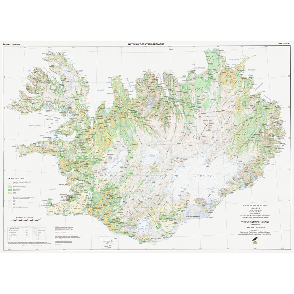
Gagnasafn (GDB) NI_G500v: Gróðurkort af Íslandi (yfirlitskort) sýnir einfaldaða samantekt á ríkjandi gróðursamfélögum. [The vegetation map of Iceland shows the predominant vegetation groups in simplified terms.] Þar sem land hefur nokkuð samfellda gróðurhulu er sýnt hvers eðlis ríkjandi gróðursamfélög eru. Hálfgróið eða minna gróið land flokkast eftir landgerð. Gróðurþekja bersvæðisgróðrar (fitjuflokkur 501) miðast við 50% eða minna. Flákalag, flokkuð eftir ÍST120:2012 staðlinum. [In areas with more-or-less unbroken vegetation cover, the predominant form of vegetation is shown. In regions where vegetation covers half of less of the area, the type of land is indicated.]
-
<p>Happywhale.com is a resource to help you know whales as individuals, and to benefit conservation science with rich data about individual whales.-nbsp;</p>
-
This dataset was compiled to describe the intertidal meiobenthic community of Kongsfjorden and to better understand the relationship between the horizontal and vertical distribution of meiofauna with a special focus on nematodes and environmental features