 Arctic SDI catalogue
Health
Type of resources
Available actions
Topics
Keywords
Contact for the resource
Provided by
Years
Formats
Representation types
Update frequencies
status
Scale
-
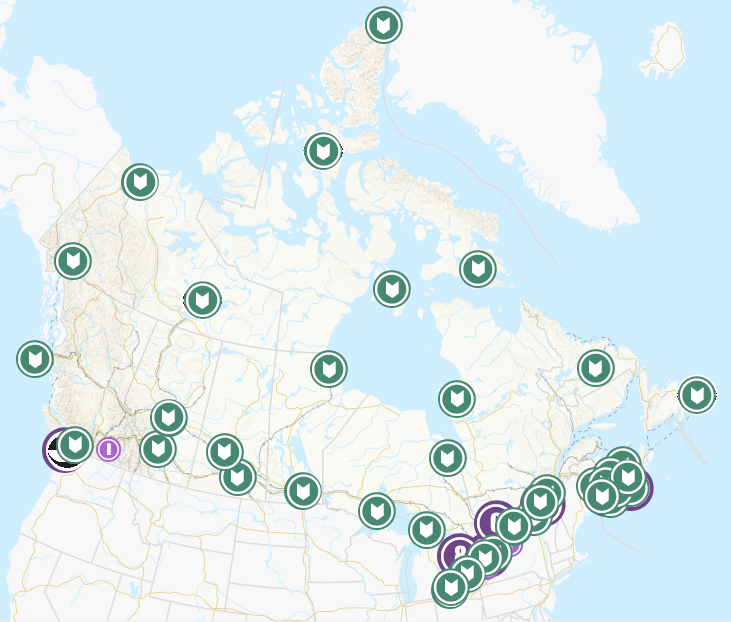
Health Canada routinely collects environmental samples for radioactivity analysis. The backbone of its monitoring comes from three separate networks: The Canadian Radiological Monitoring Network (CRMN), the Fixed Point Surveillance Network (FPS), and a Canadian contribution to the Comprehensive Nuclear-Test-Ban Treaty Organization (CTBTo). This dataset provides the approximate sampling location of the monitoring stations for each network. CRMN is a national network that routinely collects air particulate, precipitation, external gamma dose, drinking water, atmospheric water vapour, and milk samples for radioactivity analysis. The CRMN has been operating since 1959, and is used to establish long-term trends in naturally occurring environmental radioactivity, nuclear weapons fallout, as well as radioactivity generated by other human activities including nuclear power generation and medical isotope production. Full datasets for the Canadian Radiological Monitoring Network are available on the Open Government Portal. The Fixed Point Surveillance System (FPS) is an integrated network of radiation detectors providing terrestrial gamma radiation measurements in real time. The detectors are located in every province and territory of Canada with larger numbers in the vicinity of major Canadian nuclear facilities and ports where nuclear powered vessels sometimes harbour. Almost real time measurements are available on the EURDEP (EUropean Radiological Data Exchange Platform) website and monthly summaries are provided on the Health Canada website. The Comprehensive Nuclear-Test-Ban Treaty (CTBT) is a universal arms control treaty that bans all States from conducting nuclear explosions in any environment (atmosphere, underground, underwater). Canada is a signatory to the United Nations CTBT. The Radiation Protection Bureau of Health Canada is responsible for four certified radionuclide monitoring stations and a certified radionuclide laboratory. Additional information on the CTBT is available on the CTBTo website. The map shows the approximate sampling location for each monitoring station. Stations are found within the associated location range.
-

The geographic coverage of the 4 Nova Scotia Health Authority Management Zones.
-
Nova Scotia Community Community Health Networks are used for health service planning and research. Includes the following data fields: GIS_UID, GIS_SELECTED, GIS_HIDDEN, GIS_LENGTH, GIS_AREA, Network, NetworkID
-

Table of animal samples requested for rabies testing in Manitoba since the province took over the rabies program on April 1, 2014. This table contains information on animal samples requested for rabies testing in Manitoba since the province took over the rabies program on April 1, 2014. As of that date, the Canadian Food Inspection Agency (CFIA) is no longer involved with managing rabies cases in Manitoba. The provincial Rabies Management Program is now coordinated by Manitoba Rabies Central, which is a collaborative effort involving the Manitoba departments of Health, and Environment, Climate and Parks. Samples for rabies testing are requested by Manitoba Health in cases of human exposure to a suspected rabid animal, and by Agriculture in the case of animal exposure to another suspect rabid animal. Collection of a sample from the suspect rabid animal is coordinated by Agriculture. This information will be updated on a quarterly basis. This data is used in the Manitoba Rabies Surveillance Dashboard. Fields included (Alias (Field Name): Field Description.) Region (Region): Regional health authority where the affected person or animal was exposed Fiscal Year (Fiscal_Year): Government of Manitoba fiscal year (April 1-March 31) when the rabies testing was requested Date (Date): Date when the sample for rabies testing was requested Year (Year): Calendar year (January 1-December 31) when the sample for rabies testing was requested Species (Species): Animal species of the sample requested for rabies testing Result (Result): Laboratory result of the sample tested for rabies.
-

This geospatial dataset contains the geographic boundaries of the 34 Public Health Units (PHUs) in Ontario, based on Statistics Canada’s Health Region Boundary File (2018). A PHU is the area of jurisdiction of a board of health. PHUs in Ontario are defined in Regulation 553 (Revised Regulations of Ontario), pursuant to Health Protection and Promotion Act R.S.O. 1990, Amended to O. Reg. 64/05.
-

Health regions are administrative areas defined by provincial ministries of health. These administrative areas represent geographic areas of responsibility for hospital boards or regional health authorities. Health regions, being provincial administrative areas, are subject to change. For complete Canadian coverage, each of the northern territories as well as the province of Prince Edward Island represents a single health region.
-

A List of all hospitals in New Brunswick operated by Horizon Health Network
-
The name, location, hours of operation and contact information for flu shot clinics in the province. The dataset does not contain Public Health Units or your local health care provider's office, which also offer the flu shot. Data is updated each morning and is provided in JSON format. [Learn more about the flu](https://www.ontario.ca/page/flu-facts) *[JSON]: JavaScript Object Notation
-
A List of all hospitals in New Brunswick operated by Vitalité Health Network
-
[ARCHIVED] The “Nova Scotia Counties with Senior Safety Programs” dataset is no longer being updated. Please refer to https://ns.211.ca/ to learn more about seniors’ safety programs. List of counties across Nova Scotia with Senior Safety Programs