 Arctic SDI catalogue
land use
Type of resources
Available actions
Topics
Keywords
Contact for the resource
Provided by
Years
Formats
Representation types
Update frequencies
status
Service types
Scale
Resolution
-
Service for making available INSPIRE themes
-
Corine Land Cover (CLC) 2012 and CLC change 2006-2012 are two of the datasets produced within the frame of the Initial Operations of the Copernicus programme (the European Earth monitoring programme previously known as GMES) on land monitoring. Corine Land Cover (CLC) provides consistent information on land cover and land cover changes across Europe. This inventory was initiated in 1985 (reference year 1990) and established a time series of land cover information with updates in 2000 and 2006 being the last one the 2012 reference year. CLC products are based on photointerpretation of satellite images by national teams of participating countries - the EEA member and cooperating countries - following a standard methodology and nomenclature with the following base parameters: 44 classes in the hierarchical three level Corine nomenclature; minimum mapping unit (MMU) for status layers is 25 hectares; minimum width of linear elements is 100 metres; minimum mapping unit (MMU) for Land Cover Changes (LCC) for the change layers is 5 hectares. The resulting national land cover inventories are further integrated into a seamless land cover map of Europe. Land cover and land use (LCLU) information is important not only for land change research, but also more broadly for the monitoring of environmental change, policy support, the creation of environmental indicators and reporting. CLC datasets provide important datasets supporting the implementation of key priority areas of the Environment Action Programmes of the European Union as protecting ecosystems, halting the loss of biological diversity, tracking the impacts of climate change, assessing developments in agriculture and implementing the EU Water Framework Directive, among others. More about the Corine Land Cover (CLC) and Copernicus land monitoring data in general can be found at http://land.copernicus.eu .
-

**NOTE: Not for operational use. This dataset is the result of an analysis (Aug 2018) of many input layers and as such the accuracy, currency, and completeness of the dataset cannot be relied upon for operational or management decision making.** Land designations that contribute to conservation are spatially-defined areas established through legislation or purchased for the protection of nature and cultural values, the conservation of biological diversity and ecosystem services and the management of natural resources. Over 40 land designations were divided into three broad categories: - **Protected Lands** includes all Parks & Protected Areas and Other Protected Lands with the primary purpose of the long-term conservation of nature and cultural values. - **Resource Exclusion Areas** includes all designations that fully exclude one or two resource activities for the purpose of conservation. - **Spatially Managed Areas** includes all spatial designations managing or limiting development or a resource activity for the purpose of conservation, or a spatial management regime in place to preserve specified elements of biodiversity but where activity is still allowed to occur. Land designations layers were combined into a single layer, with overlaps removed such that areas with overlapping designations were assigned to the highest conservation contribution category. **Data sources:** A list of the source datasets, including links to their sources, more information, and data processing steps is available [**here**](https://raw.githubusercontent.com/bcgov/designatedlands/v0.1.0/sources.csv). Details on methods are available [**here**](https://github.com/bcgov/designatedlands). Previous versions of the data are available [**here**](https://github.com/bcgov/designatedlands/releases).
-

For most recent Ecological Land Classification data, see: https://data.novascotia.ca/d/q6zd-39t3 The Ecological Land Classification (ELC) for Nova Scotia provides a hierarchical mapping of the province's forest ecosystems into ecosections, ecodistricts and ecoregions. It includes interpretation of the dominant natural disturbance regimes and potential climax forests at the ecosection level.
-
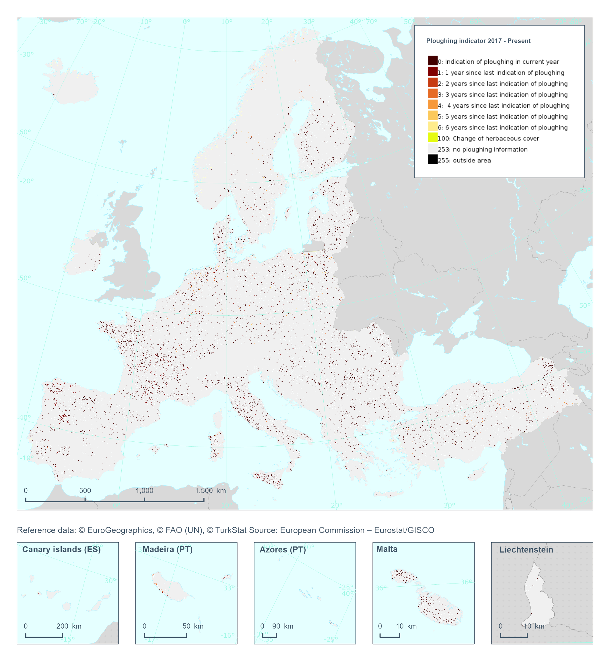
The High Resolution Layer Ploughing indicator (PLOUGH) raster product continues the 2015 and 2018 PLOUGH Layer following a rolling archive principle by adding current information and removing historic years. It indicates the number of years since the last indication of ploughing within the permanent grassland area. PLOUGH is derived by taking into account the series of binary HER layers, the BVL classifications and HR VPP PPI (Plant Phenology Index) quantiles. BVL classes 4 (crop) and 7 (overlaying layer between herbaceous and crop) indicate a ploughing event. Low HR VPP PPI quantiles indicate low vegetation at a certain time of the year. For years with missing information (2016 and earlier) the ploughing information from the historic PLOUGH product is considered which causes some issues. This dataset is provided annually starting in 2017 with 10 meter rasters (fully conformant with the EEA reference grid) in 100 x 100 km tiles covering the EEA38 countries. High Resolution Layer Grasslands product is part of the European Union’s Copernicus Land Monitoring Service. This dataset includes data from the French Overseas Territories (DOMs)
-
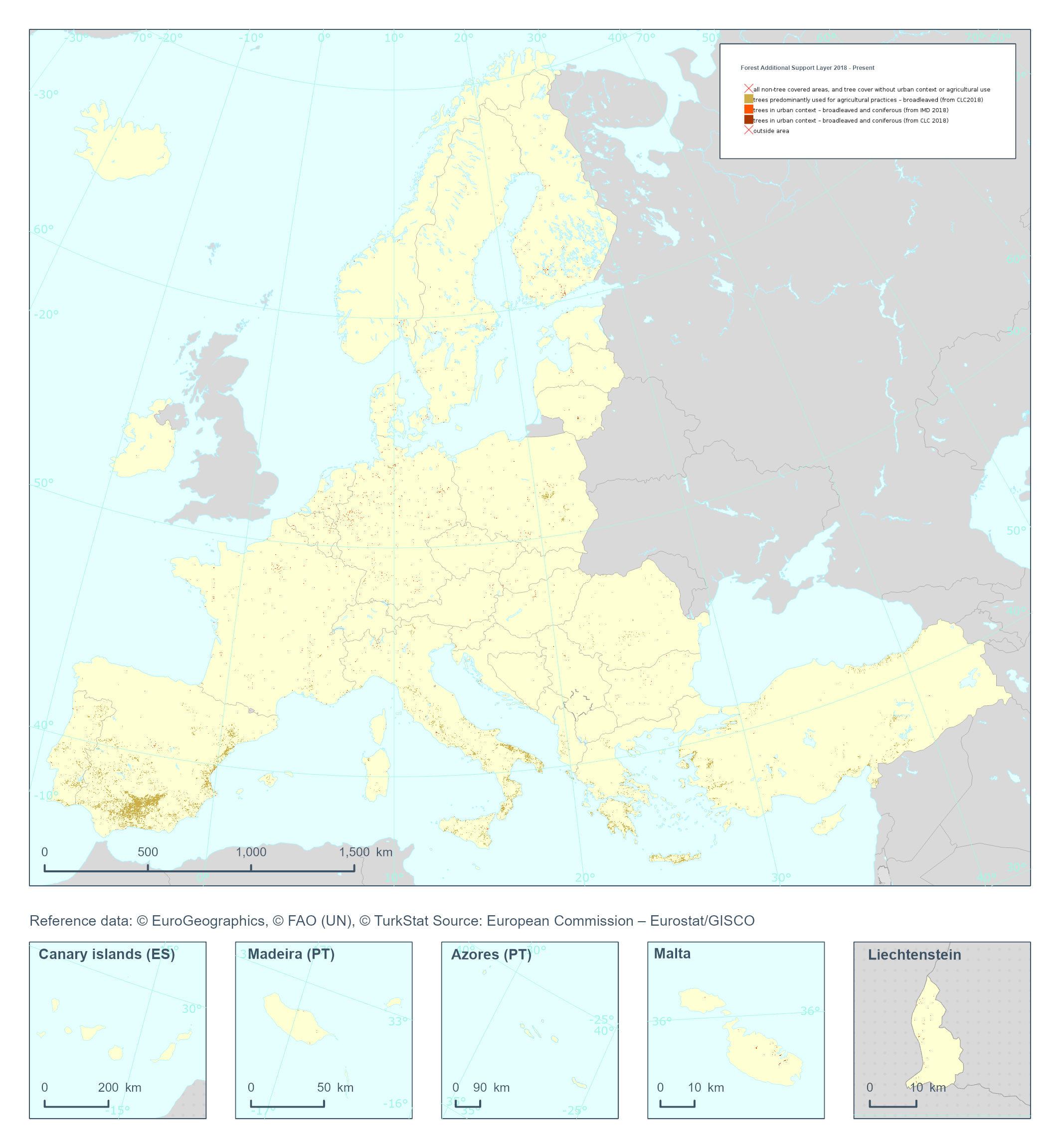
The High Resolution Layer Forest Additional Support Layer (FADSL) provides information on trees under agricultural use or in urban context to be excluded from the Forest Type (FTY) product and at 10m spatial resolution. The derivation of Forest Additional Support Layer (FADSL) is based on the spatial intersection of the 10m DLT and TCD layers with CORINE Land Cover (CLC) 2018 and HRL Imperviousness Degree 2018 with 10 m spatial resolution; TCD range of ≥ 10-100%; with a MMW of 10m and no MMU (pixel base). This dataset is provided on a 3-yearly frequency in 10 meter rasters (fully conformant with the EEA reference grid) in 100 x 100 km tiles covering the EEA38 countries. High Resolution Layer Tree Cover and Forest product is part of the European Union’s Copernicus Land Monitoring Service. This dataset includes data from the French Overseas Territories (DOMs)
-

Non-Forest cover polygons interpreted from aerial imagery on a 10 year cycle for the province of New Brunswick. The attributes contain information that describes the non-forest characteristics for that polygon area including agriculture, settlement, utility corridors, etc.
-
The Ecological Land Classification (ELC version 2015) for Nova Scotia provides a hierarchical mapping of the province's forest ecosystems into ecosections, ecodistricts and ecoregions. It includes interpretation of the dominant natural disturbance regimes and potential climax forests at the ecosection level.
-

This metadata refers to the CORINE Land Cover Plus Land Use, Land-Use Change and Forestry Instance (CLCplus LULUCF Instance), an annually updated, pan-European, spatially consistent and seamless geospatial proxy for land use reporting under the LULUCF regulation. The product is delivered as a single raster layer with a spatial resolution of 100 m, derived from multiple pan-European Copernicus Land Monitoring Service (CLMS) high resolution input datasets. The LULUCF Instance is available for the reference years 2018, 2021, 2022 and 2023, with production moving to an annual update cycle starting from the 2021 product. Each raster cell represents a dominant LULUCF land-use class, assigned according to thematic and spatial rulesets implemented during the extraction process. While each pixel corresponds primarily to one of the six main LULUCF land use categories - forest land, grassland, cropland, settlements, wetlands, and other lands - the dataset further differentiates these categories into sub classes, resulting in a total of 27 classes. This classification structure supports greenhouse gas reporting and other applications within the LULUCF sector by providing a harmonised and policy relevant representation of land use across Europe. It is crucial to understand that this product is fundamentally different from other CLMS products, as it is not based directly on satellite image classification or visual interpretation. Instead, it is produced through the combination and integration of existing CLMS data layers. Consequently, the dataset does not introduce fundamentally new information; rather, its novelty lies in the expert driven integration of multiple sources to produce a LULUCF oriented land use representation.
-

High Resolution land cover characteristics for the 2018 reference year. Small woody landscape features are important vectors of biodiversity and provide information on fragmentation of habitats with a direct potential for restoration while also providing a link to hazard protection and green infrastructure, amongst others. VHR_IMAGE_2018 made available in the ESA Copernicus DWH will be the main data source for the detection of small woody features identifiable within the given image resolution. The Small Woody Features (SWFs) layer contains woody linear and patchy elements but will not be further differentiated into trees, hedges, bushes and scrub. The spatial pattern shall be limited to linear structures and isolated patches on the basis of geometric characteristics.