 Arctic SDI catalogue
land cover
Type of resources
Available actions
Topics
Keywords
Contact for the resource
Provided by
Years
Formats
Representation types
Update frequencies
status
Service types
Scale
Resolution
-
Corine Land Cover (CLC) 2012 and CLC change 2006-2012 are two of the datasets produced within the frame of the Initial Operations of the Copernicus programme (the European Earth monitoring programme previously known as GMES) on land monitoring. Corine Land Cover (CLC) provides consistent information on land cover and land cover changes across Europe. This inventory was initiated in 1985 (reference year 1990) and established a time series of land cover information with updates in 2000 and 2006 being the last one the 2012 reference year. CLC products are based on photointerpretation of satellite images by national teams of participating countries - the EEA member and cooperating countries - following a standard methodology and nomenclature with the following base parameters: 44 classes in the hierarchical three level Corine nomenclature; minimum mapping unit (MMU) for status layers is 25 hectares; minimum width of linear elements is 100 metres; minimum mapping unit (MMU) for Land Cover Changes (LCC) for the change layers is 5 hectares. The resulting national land cover inventories are further integrated into a seamless land cover map of Europe. Land cover and land use (LCLU) information is important not only for land change research, but also more broadly for the monitoring of environmental change, policy support, the creation of environmental indicators and reporting. CLC datasets provide important datasets supporting the implementation of key priority areas of the Environment Action Programmes of the European Union as protecting ecosystems, halting the loss of biological diversity, tracking the impacts of climate change, assessing developments in agriculture and implementing the EU Water Framework Directive, among others. More about the Corine Land Cover (CLC) and Copernicus land monitoring data in general can be found at http://land.copernicus.eu .
-

This layer represents Land use polygons as determined by a combination of analytic techniques, mostly using Landsat 5 image mosaics . BTM 1 was done on a federal satellite image base that was only accurate to about 250m. The images were geo-corrected, not ortho-corrected, so there is distortion in areas of high relief. This is not a multipart feature
-

Norwegian Download service for INSPIRE LandCoverVector
-

Ontario Land Cover (OLC) is a primary data layer. It provides a comprehensive, standardized, landscape level inventory of Ontario’s natural, rural and anthropogenic (human made) features.
-
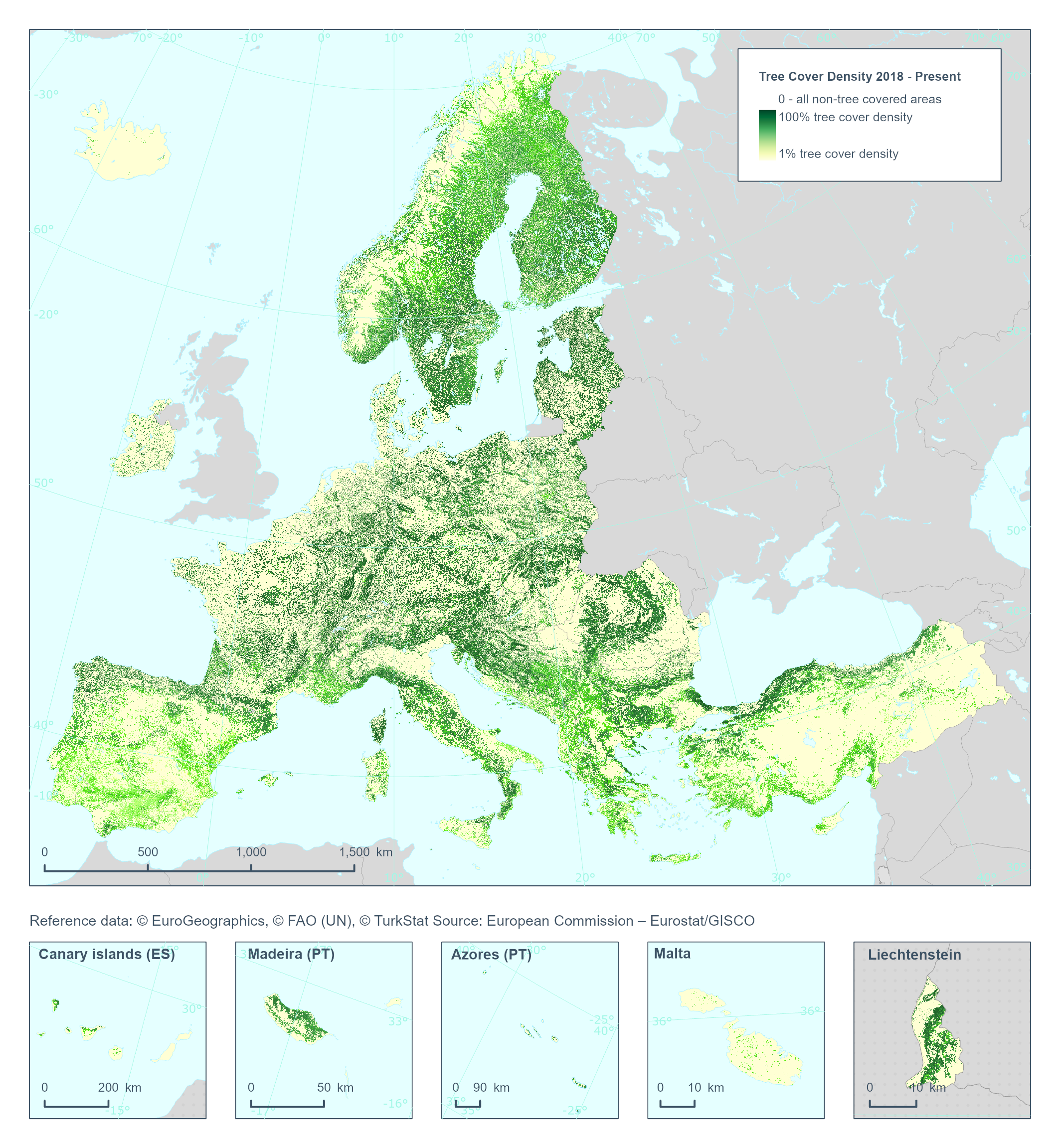
The High Resolution Layer Tree Cover Density (TCD) dataset provides information on the proportional crown coverage per pixel at 100 meter spatial resolution and ranges from 0% (all non-tree covered areas) to 100%, whereby Tree Cover Density is defined as the "vertical projection of tree crowns to a horizontal earth’s surface“. This product is an aggregation of its corresponding high resolution dataset. This dataset is provided annually starting with 2018 in 100 meter rasters (fully conformant with the EEA reference grid) in 100 x 100 km tiles covering the EEA38 countries. High Resolution Layer Tree Cover and Forest product is part of the European Union’s Copernicus Land Monitoring Service.
-

Part of the Nova Scotia Topographic Database (NSTDB), the land cover theme layer is updated and maintained from aerial photography. Land cover is limited to treed areas over 3600m2 in size and over two metres in height. Orchards, nurseries, tree lines, and single landmark trees are also included. Land Cover feature codes and their descriptions are provided with the download in a NSTDB feature code table. Data download also available via GeoNova: https://nsgi.novascotia.ca/WSF_DDS/DDS.svc/DownloadFile?tkey=fhrTtdnDvfytwLz6&id=13 Map service view also available via GeoNova: https://nsgiwa.novascotia.ca/arcgis/rest/services/BASE/BASE_NSTDB_10k_Land_Cover_UT83/MapServer?f=jsapi
-
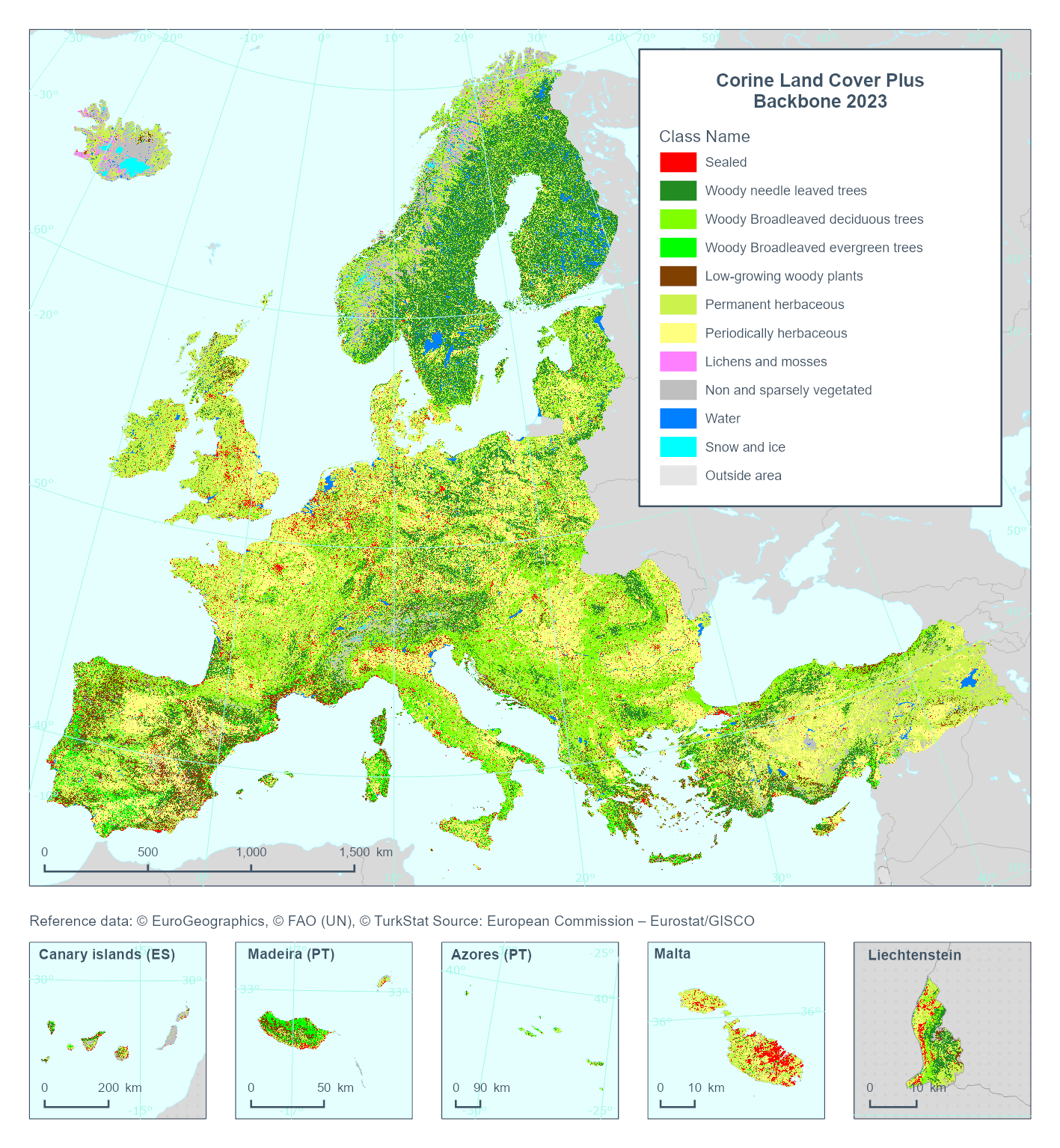
This metadata refers to the Corine Land Cover plus Backbone (CLCplus Backbone), a spatially detailed, large-scale, Earth Observation-based land cover inventory which is produced by the Copernicus Land Monitoring Service (CLMS). The CLCplus Backbone is a high-resolution raster land cover map based on Sentinel-2 satellite time series. Each 10m-pixel contains the dominant land cover among the 11 basic land cover classes. See pixel class codes in the 'Additional Information' section below. The product is available from the 2018 reference year, with a first update produced for the 2021 reference year and moved to an update cycle of 2 years from 2021 onwards.
-
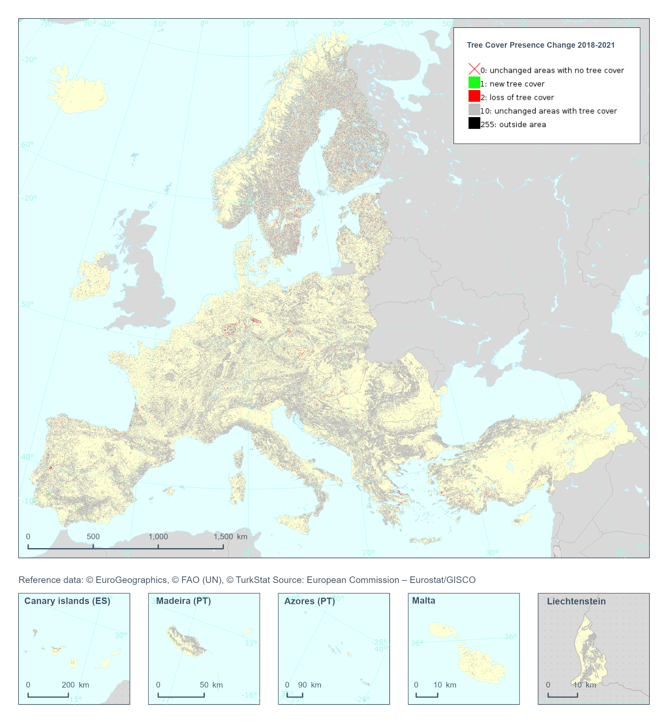
The Copernicus High Resolution Layer Tree Cover Precense Change (TCPC) 2018-2021 raster product provides information on the change between the reference years 2018 and 2021 and consists of 4 thematic classes (unchanged areas with no tree cover / new tree cover / loss of tree cover / unchanged areas with tree cover). The class 255 = outside area is predefined by the 100m boundary layer and remains unchanged. This layer for previous reference year compraissions is called Tree Cover Change Mask (TCCM). This dataset is provided in 20 meter rasters (fully conformant with the EEA reference grid) in 100 x 100 km tiles covering the EEA38 countries. The production of the high resolution forest layers was coordinated by the European Environment Agency (EEA) in the frame of the EU Copernicus programme. Confidence layer available for the dataset. This dataset includes data from the French Overseas Territories (DOMs)
-
Part of the Nova Scotia Topographic Database (NSTDB), the land cover theme layer is updated and maintained from aerial photography. Land cover is limited to treed areas over 3600m2 in size and over two metres in height. Orchards, nurseries, tree lines, and single landmark trees are also included. Land Cover feature codes and their descriptions are provided with the download in a NSTDB feature code table. Data download also available via GeoNova: https://nsgi.novascotia.ca/WSF_DDS/DDS.svc/DownloadFile?tkey=fhrTtdnDvfytwLz6&id=13 Map service view also available via GeoNova: https://nsgiwa.novascotia.ca/arcgis/rest/services/BASE/BASE_NSTDB_10k_Land_Cover_UT83/MapServer?f=jsapi