 Arctic SDI catalogue
boundaries
Type of resources
Available actions
Topics
Keywords
Contact for the resource
Provided by
Years
Formats
Representation types
Update frequencies
status
Service types
Scale
Resolution
-

Postala gränsdragningar i vektorform - Svenska postnummer på 1-, 2-, 3 samt 5-siffrig nivå - Svenska postorter
-
Skogsstyrelsen administrativa indelning i distrikt och regioner.
-

In 2021, the Canada Coast Guard (CCG) and Fisheries and Oceans Canada updated its administrative boundaries following the creation a new Arctic region. There are now 4 administrative regions in CCG (Western, Arctic, Central and Atlantic). DFO and Coast Guard Arctic Regions developed these regions in partnership with the people they serve; this important decision will lead to stronger programs and services to better meet the unique needs of our Arctic communities. DFO and CCG operations and research cover Canada's land and waters to the international boundaries (EEZ) and are in no way limited to the boundaries drawn in the map.
-

Canadian Hydrographic Service (CHS) has made available all the publishable limits of modern day surveys whose data has been collected since 1989.
-
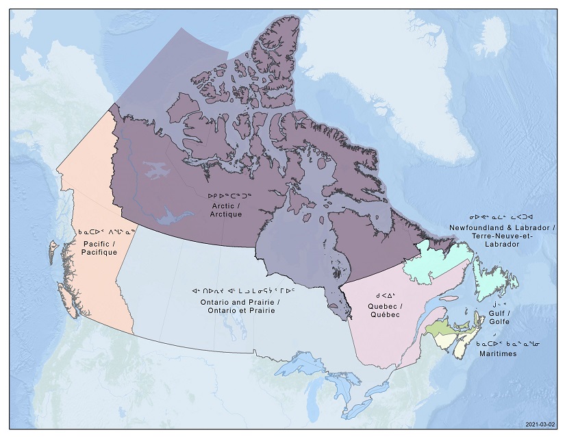
In 2021, the Canada Coast Guard (CCG) and Fisheries and Oceans Canada (DFO) updated its administrative boundaries following the creation a new Arctic region.There are now 7 administrative regions in DFO (Pacific, Arctic, Ontario and Prairie, Quebec, Gulf, Maritimes, Newfoundland and Labrador). DFO and Coast Guard Arctic Regions developed these regions in partnership with the people they serve; this important decision will lead to stronger programs and services to better meet the unique needs of our Arctic communities.DFO and CCG operations and research cover Canada's land and waters to the international boundaries (EEZ) and are in no way limited to the boundaries drawn in the map.
-

Location data for natural gas distributors’ service areas boundaries that can be used in geographic information systems (GIS) applications.
-

Polygons and line shapefiles for the final version of the proposed electoral boundaries.
-
Datamängd innehållande administrativa områden för kommuner, län och rike från grunddata anpassat för skalområde 1:10 000. Datamängden kan inte beställas separat utan ingår endast i befintliga tjänster: Administrativ indelning Nedladdning Inspire och Basemap Visning, Inspire. Dataset containing administrative units of municipalities, counties and the kingdom from basic data adjusted for scale range 1:10 000. The dataset can´t be ordered separately. It is only included in existing service: Administrative unit Download INSPIRE and Base map View Service INSPIRE.
-
Distriktsindelning Nedladdning, vektor visar Sveriges indelning i distrikt, som ytor med distriktskod och distriktsnamn som attribut. Denna geografiska indelning av vårt land utgörs av 2523 områden.
-
Socken och stad Nedladdning, vektor bygger på de jordregistersocknar som var aktuella i samband med övergången till nytt fastighetsregister 1976–1995 samt de stadsregisterområden som var stad med stadsprivilegier i samband med kommunreformen 1971.