 Arctic SDI catalogue
structure
Type of resources
Available actions
Topics
Keywords
Contact for the resource
Provided by
Years
Formats
Representation types
Update frequencies
status
Service types
Scale
Resolution
-

This dataset series highlights the locations of research centres where scientists, technicians and staff work to create better opportunities for farmers and all Canadians through agricultural research and innovation.
-
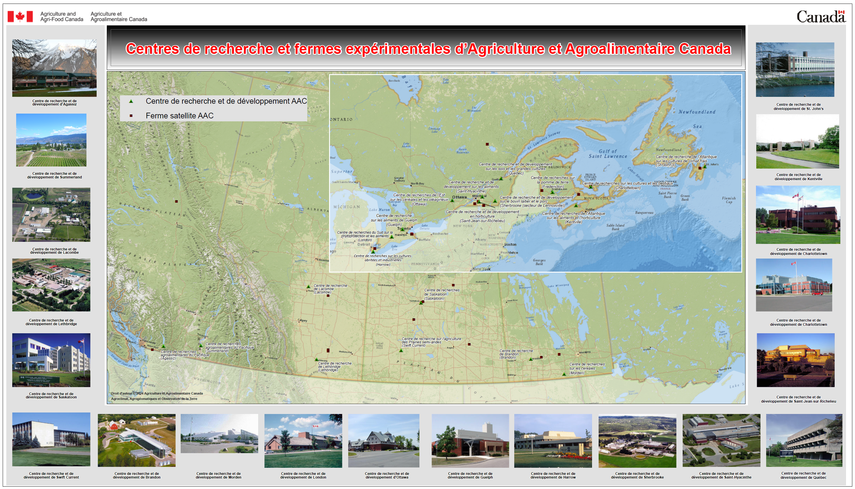
This dataset highlights the network of Research and Development farms associated with Agriculture and Agri-Food Canada that conduct research and collaborate with partners and stakeholders.
-
Datamängd för alla byggnader med undantag för avregistrerade byggnader. Datamängden kan inte beställas separat utan ingår endast i befintliga tjänster: Byggnad Nedladdning Inspire och Basemap Visning, Inspire. Dataset for all buildings except for unregistered buildings. The dataset can’t be ordered separately. It is only included in existing services: Building Download IINSPIRE and Base map View Service INSPIRE
-
Datasetet visar det geografiska läget för enskilda och statliga byggnadsminnen och kyrkor som är registrerade i Bebyggelseregistret. Datasetet ingår i INSPIRE-direktivets tema byggnader. Observera! Geodatatjänsterna är ännu inte utbytta enligt det nya Bebyggelseregistrets informationsmodell. Detta kommer att ske under våren 2025. När dessa är utbytta behöver ni som byggt egna tjänster på data ur Bebyggelseregistret bygga om dessa. Informationen här uppdateras så snart vi vet närmare tidpunkt för när bytet kommer att ske.
-

Gagnagrunnur Vegagerðarinnar inniheldur upplýsingar um fastmerki sem Vegagerðin er með sínum gagnagrunni. Þetta eru ýmist fastmerki sem Vegagerðin hefur sett út eða fastmerki annarra fyrirtækja og stofnanna.
-

Verndarsvæði í Reykjavík, samkvæmt aðalskipulagi. Hægt er að hlaða öllum gögnum niður hér eða sækja sem vefþjónustu https://data-reykjavik.opendata.arcgis.com/datasets/24abed11c2fc4981ac89d1fd1357e1ab/explore?layer=0
-

[IS] Fornleifar og yngri minjar Upplýsingar eru fengnar frá Borgarsögusafni Reykjavíkur og innihlada upplýsingar um minjastaði. Hægt er að fá fleiri upplýsingar um minjarnar í Sarpi - menningarsögulegu gagnasafni. Fornleifaskráningu fyrir Reykjavík er ekki lokið og þessi skráning telst ekki nægjanleg sem fornleifaskráning vegna deiliskipulags né vegna útgáfu leyfis til framkvæmda. [EN] Archaeological Sites and More Recent Cultural Remains The information is obtained from the Reykjavík City Museum and contains data about heritage sites. More information about the remains can be found in Sarpur — the cultural heritage database. The archaeological survey for Reykjavík is not complete, and this dataset is not considered sufficient as an official archaeological record for detailed planning purposes or for the issuance of construction permits.
-

Aðalskipulag Reykjavíkur 2040 er uppfærð og endurbætt útgáfa AR2030, sem samþykkt var árið 2014. Aðalskipulagið var samþykkt í borgarstjórn Reykjavíkur þann 19.október 2021, samanber einnig samþykkt hennar 21. desember 2021. Aðalskipulagið var undirritað þann 13. janúar 2022 og tók gildi með birtingu í Stjórnartíðindum þann 18. janúar 2022 Hægt er að skoða bæði skipulagið í heild og einnig einstaka kafla hér Í skipulagssjánni er birt stafræn útgáfa af þéttbýlis- og sveitarfélagsuppdrætti Aðalskipulags Reykjavíkur 2040, ásamt skilgreiningum landnotkunar fyrir helstu svæði. Í álitamálum og ef misræmi kemur í ljós, milli útgáfu aðalskipulagsins sem birtist í skipulagssjánni og undirritaðrar útgáfu þess (sjá hér), gildir það sem fram kemur í undirrituðum gögnum. Varðandi nánari stefnumörkun fyrir einstök landnotkunarsvæði og afmörkun þeirra, t.d. miðborgina, vísast til undirritaðrar útgáfu aðalskipulagsins.
-
“Automatically Extracted Buildings” is a raw digital product in vector format created by NRCan. The feature classes of this product delineate polygonal building footprints automatically extracted from airborne Lidar data, high-resolution optical imagery or other sources. The first feature class, Automatically Extracted Buildings by acquisition source, contains building footprints delivered according to the spatial extent of each source dataset used for extraction. When the spatial extents of acquisition sources overlap, footprints for the same building may therefore be duplicated in this class. The second feature class, Optimized Buildings Layer, is an assembled and harmonized layer derived from the buildings by acquisition source. Its objective is to provide a unique representation of each building footprint by removing duplicates and resolving overlaps between sources.
-

STR - Facilities and structures (structure)Man-made construction. For example, resources describing buildings, museums, churches, schools, hospitals, factories, housing, monuments, and towers.