 Arctic SDI catalogue
Land use
Type of resources
Available actions
Topics
Keywords
Contact for the resource
Provided by
Years
Formats
Representation types
Update frequencies
status
Service types
Scale
Resolution
-
Web Map Service providing access to Existing Land use from Danish Agency for Data supply and Efficiency. The contents are data from the data set "GeoDanmark", transformed to the INSPIRE ELU GML application schema v4.0.
-

Land og skógur, skoðunarþjónustur (áður Skógræktin).
-

Land og skógur, niðurhalsþjónustur (áður Skógræktin).
-

The “Land Cover for Agricultural Regions of Canada, circa 2000” is a thematic land cover classification representative of Circa 2000 conditions for agricultural regions of Canada. Land cover is derived from Landsat5-TM and/or 7-ETM+ multi-spectral imagery by inputting imagery and ground reference training data into a Decision-Tree or Supervised image classification process. Object segmentation, pixel filtering, and/or post editing is applied as part of the image classification. Mapping is corrected to the GeoBase Data Alignment Layer. National Road Network (1:50,000) features and other select existing land cover products are integrated into the product. UTM Zone mosaics are generated from individual 30 meter resolution classified scenes. A spatial index is available indicating the Landsat imagery scenes and dates input in the classification. This product is published and compiled by Agriculture and Agri-Food Canada (AAFC), but also integrates products mapped by other provincial and federal agencies; with appropriate legend adaptations. This release includes UTM Zones 9, 10, 11, 12, 13, 14, 15, 16, 17, 18, 19, 20, 21, and 22 for corresponding agricultural regions in Newfoundland, Prince Edward Island, Nova Scotia, New Brunswick, Québec, Ontario, Manitoba, Saskatchewan, Alberta and British Columbia covering approximately 370,000,000 hectares of mapped area. Mapped classes include: Water, Exposed, Built-up, Shrubland, Wetland, Grassland, Annual Crops, Perennial Crops and Pasture, Coniferous, Deciduous and Mixed forests. However, emphasis is placed on accurately delineating agricultural classes, including: annual crops (cropland and specialty crops like vineyards and orchards), perennial crops (including pastures and forages), and grasslands.
-
Gagnasett sem sýnir yfirlitsupplýsingar um helstu svæði þar sem landgræðsla er stunduð og Land og skógur kemur að á einn eða annan hátt. Undanskilin eru þó svæði í verkefninu Bændur græða landið.
-
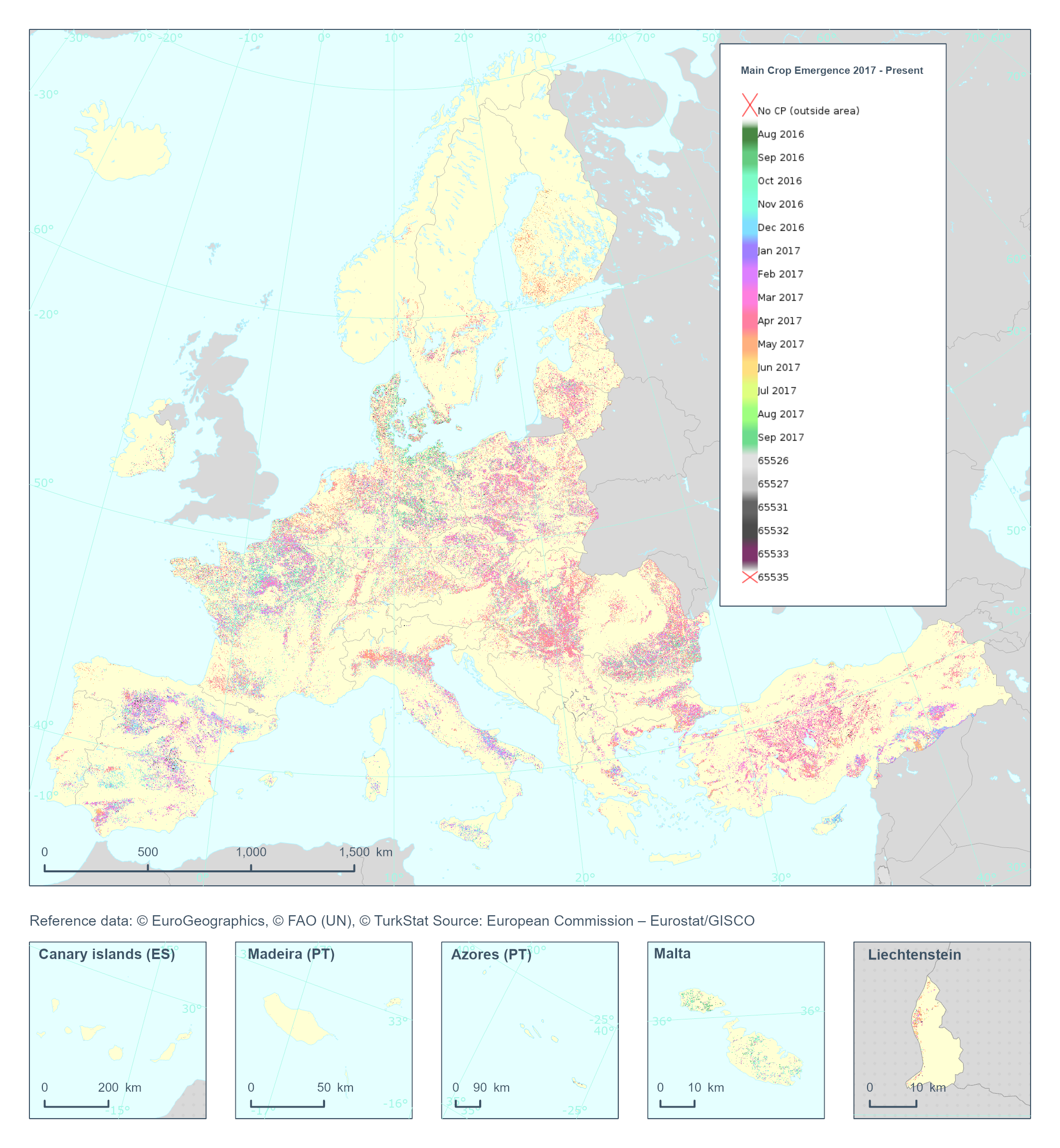
The High Resolution Layer Cropping Patterns - Main Crop Emergence (CPMCE) raster product provides the emergence date of the main (annual) crop expressed in DOY (day of year). YYDOY where YY = last 2 digits of the year (e.g. 19 for 2019) and DOY is the day of the year (1-365). This dataset is provided annually starting in 2017 with 10 meter rasters (fully conformant with the EEA reference grid) in 100 x 100 km tiles covering the EEA38 countries. High Resolution Layer Croplands product is part of the European Union’s Copernicus Land Monitoring Service. Confidence layer available for the dataset. This dataset includes data from the French Overseas Territories (DOMs)
-
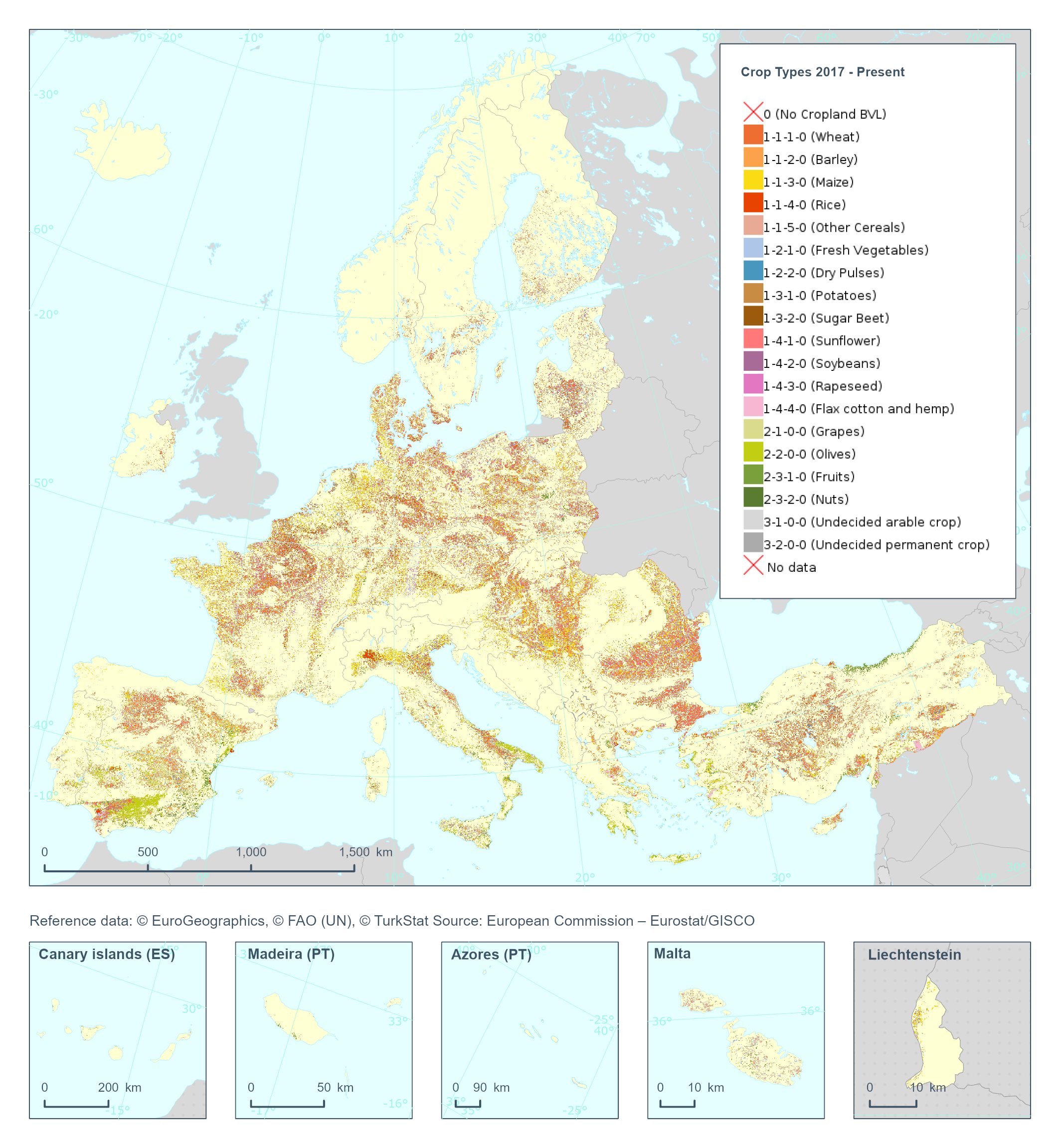
The High Resolution Layer Crop Types (CTY) raster product provides high resolution crop type classification for 17 classes of both arable and permanent crops accross the EEA38 extent. Using both Sentinel-1 and Sentiel-2, the model is finetuned to first map the crop field boundaries, and then determine the main crop for each field. This dataset is provided annually starting in 2017 with 10 meter rasters (fully conformant with the EEA reference grid) in 100 x 100 km tiles covering the EEA38 countries. High Resolution Layer Croplands product is part of the European Union’s Copernicus Land Monitoring Service. Confidence layer available for the dataset. This dataset includes data from the French Overseas Territories (DOMs)
-
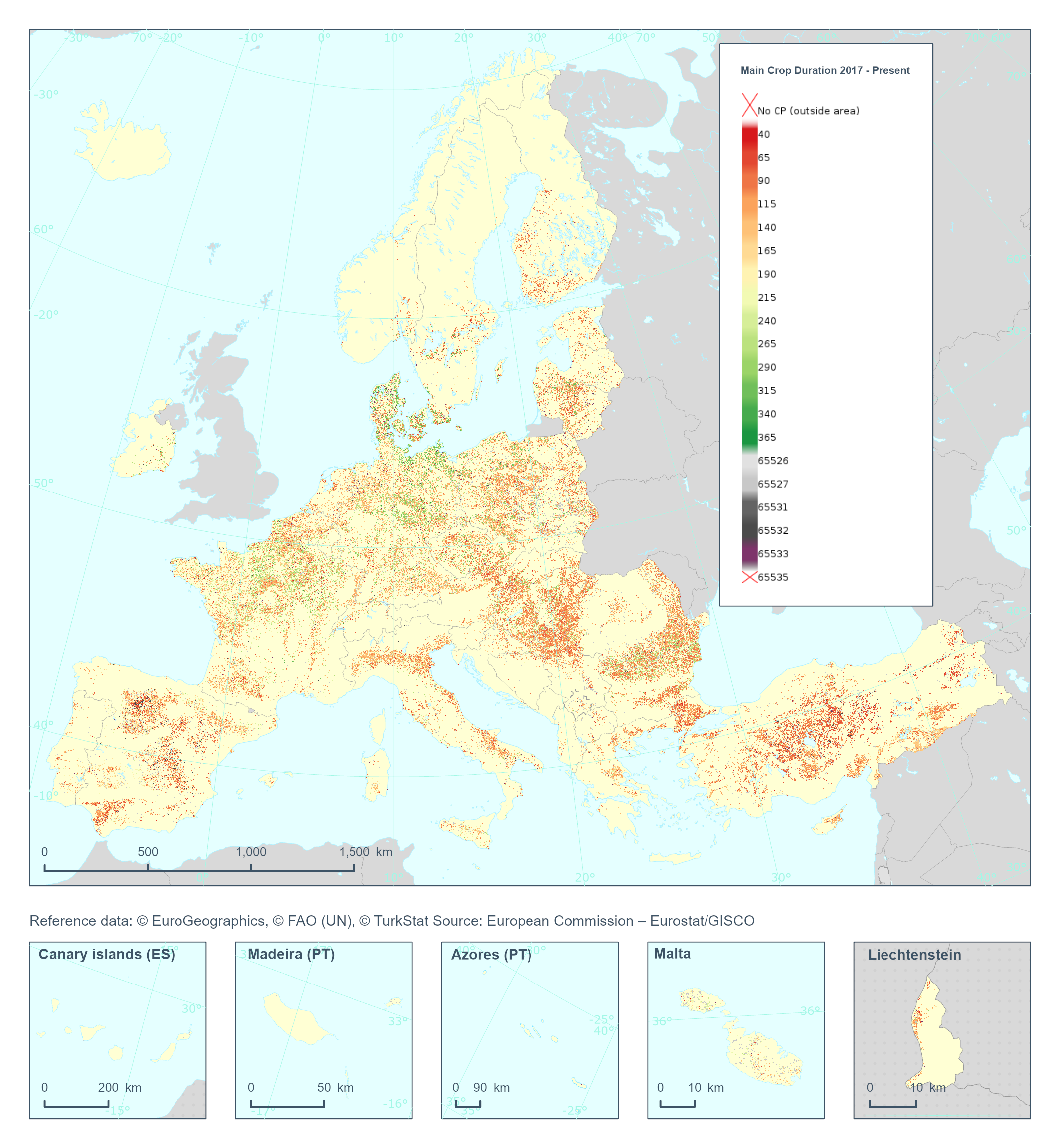
The High Resolution Layer Cropping Patterns - Main Crop Duration (CPMCD) raster product provides the duration (in days) of the growing season for the main (annual) crop. This dataset is provided annually starting in 2017 with 10 meter rasters (fully conformant with the EEA reference grid) in 100 x 100 km tiles covering the EEA38 countries. High Resolution Layer Croplands product is part of the European Union’s Copernicus Land Monitoring Service. Confidence layer available for the dataset. This dataset includes data from the French Overseas Territories (DOMs)
-
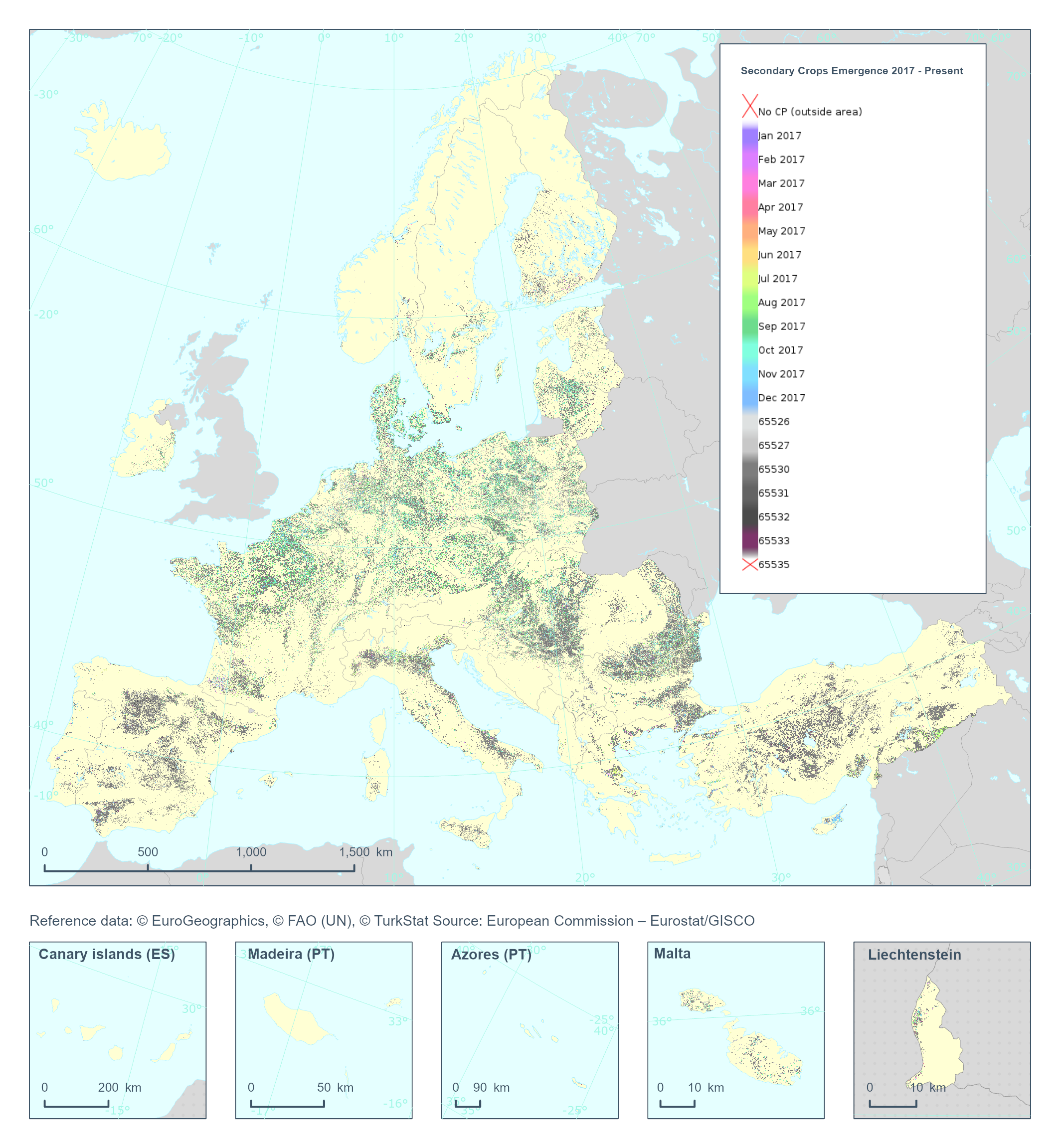
The High Resolution Layer Cropping Patterns - Secondary Crop Emergence (CPSCE) raster product provides the date of emergence of the cover crop in days of the year (DOY). YYDOY where YY = last 2 digits of the year (e.g. 19 for 2019) and DOY is the day of the year (1-365) This dataset is provided annually starting in 2017 with 10 meter rasters (fully conformant with the EEA reference grid) in 100 x 100 km tiles covering the EEA38 countries. High Resolution Layer Croplands product is part of the European Union’s Copernicus Land Monitoring Service. Confidence layer available for the dataset. This dataset includes data from the French Overseas Territories (DOMs)
-
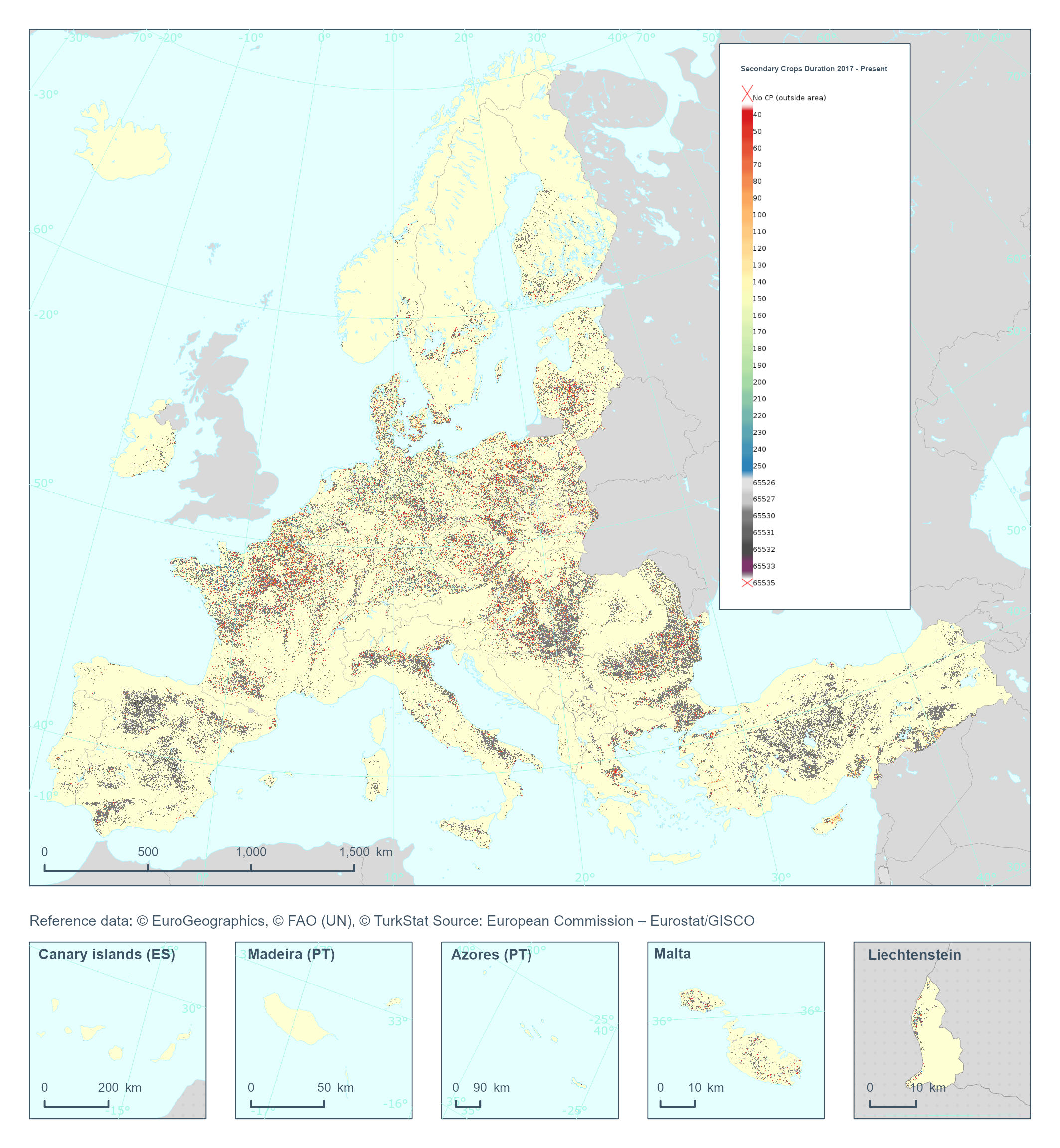
The High Resolution Layer Cropping Patterns - Secondary Crop Harvest (CPSCH) raster product provides the duration (in days) of the cover crop season (can exceed the calendar year). This dataset is provided annually starting in 2017 with 10 meter rasters (fully conformant with the EEA reference grid) in 100 x 100 km tiles covering the EEA38 countries. High Resolution Layer Croplands product is part of the European Union’s Copernicus Land Monitoring Service. Confidence layer available for the dataset. This dataset includes data from the French Overseas Territories (DOMs)