 Arctic SDI catalogue
geoscientificInformation
Type of resources
Available actions
Topics
Keywords
Contact for the resource
Provided by
Years
Formats
Representation types
Update frequencies
status
Scale
Resolution
-
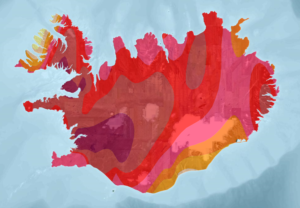
The dataset presents three layers of geothermal data from Iceland based on "Atlas of Geothermal Resources in Europe" (2002). Heat-flow density, Temperature at 1000 meters and Temperature at 2000 meters (1:10 000 000).
-
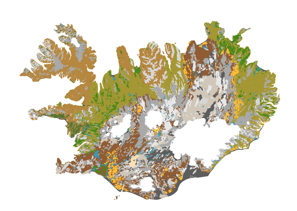
Íslenskur jarðvegur telst til eldfjallajarðar (Andosol) að langmestum hluta, en eldfjallajörð er jarðvegur sem myndast á eldvirkum svæðum heimsins. Eldfjallajörð hefur afar sérstæða eiginleika sem greina hana frá öðrum jarðvegsgerðum. Útbúin var einföld flokkun fyrir íslenskan jarðveg, sem m.a. byggist á alþjóðlegum flokkunarkerfum en einnig á vinnu Björns Jóhannessonar og Þorsteins Guðmundssonar. Flokkunin gerir greinarmun á i) jarðvegi auðna (glerjörð sem skiptist í melajörð, malarjörð, sandjörð og vikurjörð; ii) jarðvegi gróins lands með sortueiginleika (sortujörð, sem skiptist í brúnjörð, votjörð og svartjörð), iii) lífrænni mójörð og að síðustu iv) öðrum jarðvegi sem er margvíslegur að gerð. Í síðasta flokknum er bergjörð útbreiddust, en auk þess má nefna frerajörð sífrerasvæða og kalkjörð. Jarðvegskortið var unnið á grundvelli sniða og jarðvegssýna sem safnað hefur verið víða um landið. Kortið er á vektora formi og í mælikvarða 1:500 000. Það er m.a. hluti evrópska jarðvegskortsins. A soil map of Iceland: The Soil map classification separates between; 1) andic soils, which are Brown Andosols, Gleyic Andosols and Histic Andosols; 2) Vitrisols, soils of deserts, which are divided into Cambic Vitrisols, Gravelly Vitrisols, Arenic Vitrisols and Pumice Vitrisols iii) Histosols, and iv) other soil types such as Cryosols and Leptosols. The classification system is in part based on WRB system and Soil Taxonomy and earlier work by Björn Jóhannesson and Þorsteinn Guðmundsson (see English Summary and 1. table in http://www.moldin.net/uploads/3/9/3/3/39332633/jardvegskort_2.pdf). The map is in a coarse scale (1:500 000) and is not intended to use for particular points on the landscape. It is rather an overview. It has been incorporated into the EU soil database and the Circumpolar soil map.
-

Gagnasafn (GDB) NI_J600v_hoggun: Jarðfræðikorti af Íslandi – Höggun – 1:600.000 [Geological Map of Iceland – Tectonics – 1:600.000]. Höggunarkort af Íslandi sýnir jarðfræði landsins á nýstárlegan hátt. Jarðlög eru flokkuð eftir aldri en ekki eftir gerð og samsetningu. Sýnd eru eldstöðvakerfi, þ.e. megineldstöðvar, sprungu- og gangareinar, bæði virkar og útkulnaðar. Einnig eru sýnd helstu brotakerfi landsins og halli jarðlaga. Kortið gefur innsýn í jarðfræðilega byggingu landsins. [The Tectonic Map of Iceland gives a new view of the country's geology. The rocks are classified by age, but not by type or composition. Volcanic systems including central volcanoes, fissures and dyke swarms, both active and extinct, are shown, as are the island's principal fracture zones and the dip of rock layers. The map thus gives a useful insight into the geological structure of the country.]
-
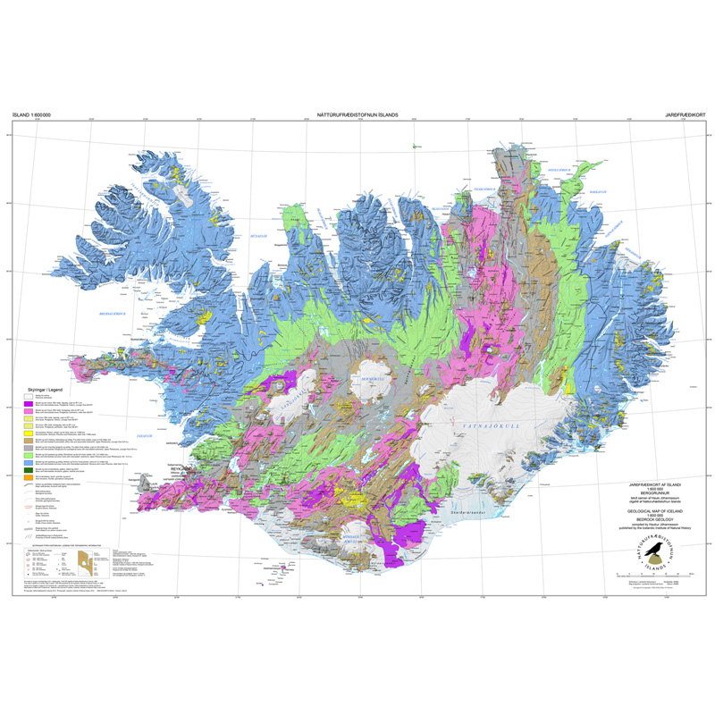
Gagnasafn (GDB) NI_J600v_berg_2.utg: Jarðfræðikorti af Íslandi – Berggrunnur – 1:600.000 [Geological Map of Iceland – Bedrock geology – 1:600.000]. Berggrunnskort af Íslandi sýnir stærstu drættina í jarðfræði landsins. Jarðlög eru flokkuð eftir aldri, gerð og samsetningu. Kortið sýnir vel gosbelti landsins og dreifingu gossstöðva frá nútíma. Nútímahraunum er skipt í forsöguleg og söguleg hraun (yngri en 871 e. Kr. ). [The Geological Map of Iceland shows the main features of the bedrock geology. Formation are classified by age, type, and composition. The map clearly shows the island's volcanic zones and the distribution of the recent eruption sites. Lava fields of the Holocene are shown as pre-historic or historic (younger than AD 871].]
-
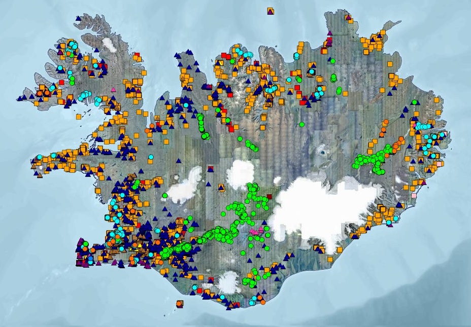
Gagnasett sem sýnir yfirlitsupplýsingar úr Borholugrunni Umhverfis- og orkustofnunar um borholur á Íslandi. Fram koma meðal annars: auðkennisnúmer borholu, borholunafn, staðarheiti, bortími, dýpi, sveitarfélag, eldra hreppsnafn, landnúmer, tilgangur og tegund borunar, bor og borfyrirtæki, staðsetningarhnit í ISN93 og WGS84, gæði hnita, fóðringardýpi og holuvídd. Í töflunni eru yfir 15.000 færslur. Upplýsingar úr gagnatöflunni eru bæði aðgengilegar á vefsíðu UOS og í Kortasjá UOS.
-

The Geological Atlas of the Western Canada Sedimentary Basin was designed primarily as a reference volume documenting the subsurface geology of the Western Canada Sedimentary Basin. This GIS dataset is one of a collection of shapefiles representing part of Chapter 17 of the Atlas, Paleographic Evolution of the Western Canada Foreland Basin, Figure 1, Basal Nikanassin/Morrissey/Swift/Success (S-1) Paleogeography. Shapefiles were produced from archived digital files created by the Alberta Geological Survey in the mid-1990s, and edited in 2005-06 to correct, attribute and consolidate the data into single files by feature type and by figure.
-
The Geological Atlas of the Western Canada Sedimentary Basin was designed primarily as a reference volume documenting the subsurface geology of the Western Canada Sedimentary Basin. This GIS dataset is one of a collection of shapefiles representing part of Chapter 17 of the Atlas, Paleographic Evolution of the Western Canada Foreland Basin, Figure 6, Middle Upper Mannville (and Equivalents) Paleogeography. Shapefiles were produced from archived digital files created by the Alberta Geological Survey in the mid-1990s, and edited in 2005-06 to correct, attribute and consolidate the data into single files by feature type and by figure.
-
This GIS dataset depicts the drift thickness of NTS map area 84M ( line features). The data are created in ArcGIS and output for public distribution in shapefile formats.
-
The Geological Atlas of the Western Canada Sedimentary Basin was designed primarily as a reference volume documenting the subsurface geology of the Western Canada Sedimentary Basin. This GIS dataset is one of a collection of shapefiles representing part of Chapter 24 of the Atlas, Uppermost Cretaceous and Tertiary Strata of the Western Canada Sedimentary Basin, Figure 22, Post-Paleocene Deposits. Shapefiles were produced from archived digital files created by the Alberta Geological Survey in the mid-1990s, and edited in 2005-06 to correct, attribute and consolidate the data into single files by feature type and by figure.
-
The Geological Atlas of the Western Canada Sedimentary Basin was designed primarily as a reference volume documenting the subsurface geology of the Western Canada Sedimentary Basin. This GIS dataset is one of a collection of shapefiles representing part of Chapter 31 of the Atlas, Petroleum Generation and Migration in the Western Canada Sedimentary Basin, Figure 24, Cretaceous Colorado Group Petroleum System. Shapefiles were produced from archived digital files created by the Alberta Geological Survey in the mid-1990s, and edited in 2005-06 to correct, attribute and consolidate the data into single files by feature type and by figure.